Caldbeck
![]()
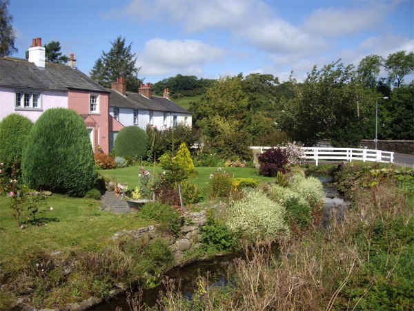
![]() The pretty Cumbrian village of Caldbeck has some nice walking trails to try along the Cald Beck. There's attractive riverside woodland, rushing waterfalls and good climbs to the nearby fells to enjoy.
The pretty Cumbrian village of Caldbeck has some nice walking trails to try along the Cald Beck. There's attractive riverside woodland, rushing waterfalls and good climbs to the nearby fells to enjoy.
This figure of eight walk uses a section of the long distance Cumbria Way and other public footpaths to explore the area to the east and west of the village. The western section is very pretty, taking you along the Cald Beck to the Howk where there are a series of pretty waterfalls. It's a delightful area with lots of little streamside cottages, rushing water, limestone gorge scenery and the remains of an old waterwheel at Bobbin Mill. Just before reaching Whelpo the route climbs away from the river to climb Brownrigg. At nearly 1000ft the hill gives great views over the surrounding countryside.
The eastern section of the trail follows the Cald Beck and the River Caldew towards Sebergham. You then climb to Parkhead for more nice views, before returning to the village.
To extend your walking in the area you can head south along the Cumbria Way to the Caldbeck Fells and climb High Pike for more great views over north Lakeland.
Heading south west along the Cumbria Way will take you to Bassenthwaite Lake.
Also nearby is Greystoke Forest where there are miles of good mountain bike trails and footpaths to try.
Caldbeck Ordnance Survey Map  - view and print off detailed OS map
Caldbeck Open Street Map  - view and print off detailed map
Caldbeck OS Map  - Mobile GPS OS Map with Location tracking
Caldbeck Open Street Map  - Mobile GPS Map with Location tracking
Walks near Caldbeck
- High Pike - This walk climbs to High Pike from the village of Caldbeck in the Lake District
- Greystoke Forest - This large area of woodland near Penrith has miles of cycling and walking trails to try
- Cumbria Way - Travel through the beautiful Lake District National Park on this stunning walk
- Bassenthwaite Lake - This walk takes you to the lovely Bassenthwaite Lake from Keswick in the Lake District
- Sale Fell - This circular walk climbs to Sale Fell near Cockermouth in the Lake District National Park.


