Chillington Hall Walks
![]()
![]() This Georgian country house includes some lovely Capability Brown landscaped parkland and gardens to explore.
This Georgian country house includes some lovely Capability Brown landscaped parkland and gardens to explore.
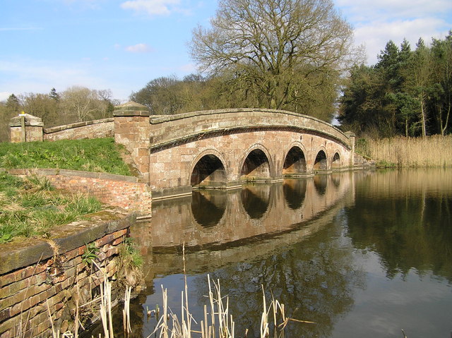
There's also a large lake, a canal and peaceful woodland trails which are covered in bluebells during the spring months. There are orgainsed autumn walks and house tours where you can learn about the history of the 18th century hall. The grounds are only open on a select number of days of the year. See the more information link below for detais.
Postcode
WV8 1RE - Please note: Postcode may be approximate for some rural locationsPlease click here for more information
Chillington Hall Ordnance Survey Map  - view and print off detailed OS map
Chillington Hall Open Street Map  - view and print off detailed map
Chillington Hall OS Map  - Mobile GPS OS Map with Location tracking
Chillington Hall Open Street Map  - Mobile GPS Map with Location tracking
Dog Walking
Dogs are allowed on leads within the parkland.
Further Information and Other Local Ideas
The Brewood Canal Walk which visits the hall and the Shropshire Union Canal, Wheaton Aston and Belvide Reservoir. The circular Codsall Walk also passes the hall.
At nearby Weston Park you'll find another historic 17th century hall with Capability Brown parkland. There's several waymarked walking trails taking you around the 1000 acre site.
In nearby Wombourne you could pay a visit to the 18th century Himley Hall. The historic hall is surrounded by ‘Capability’ Brown landscaped parkland with woodland walks, waterfalls and a large lake.
For more walking ideas in the area see the Staffordshire Walks page.
Cycle Routes and Walking Routes Nearby
Photos
The Sham Bridge. As the title suggest this is not a bridge but a causeway over the northern end of the lake known as Chillington Pool.


