Cnicht Walk
![]()
![]() Climb to the 'Matterhorn of Wales' on this challenging walk from the village of Croesor in Gwynedd. Although several thousand metres lower, Cnicht has a similar appearance to the famous mountain of the Alps.
Climb to the 'Matterhorn of Wales' on this challenging walk from the village of Croesor in Gwynedd. Although several thousand metres lower, Cnicht has a similar appearance to the famous mountain of the Alps.
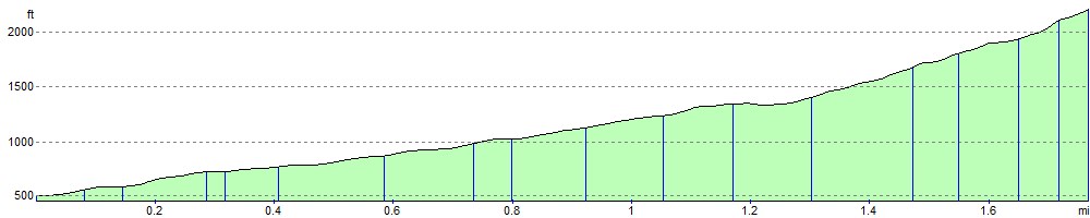
It's about a 2 mile walk from the village to the 689 m (2,260 ft) summit. It's generally a good stony path with some grassy sections as well. There is some scrambling required as you make your way to the top though. Cnicht is generally a very peaceful place with stunning views to the coast at Porthmadog from the summit.
The walk begins in Croesor where there is a small car park. Then head north out of the village on a country lane before a stony track climbs through woodland. When you come out of the woodland section there are splendid views of the surrounding hills and mountains. The path continues in a north easterly direction, climbing steadily towards the summit.
You can turn it into a longer circular walk by descending to Cwm Croseor and returning along the Afon Croesor.
The Moelwyn Mawr Walk starts from the same car park if you'd like to continue your climbing in the area.
You can virtually climb to Cnicht using the google street view link below!
Postcode
LL48 6SS - Please note: Postcode may be approximate for some rural locationsCnicht Ordnance Survey Map  - view and print off detailed OS map
Cnicht Open Street Map  - view and print off detailed map
*New* - Walks and Cycle Routes Near Me Map - Waymarked Routes and Mountain Bike Trails>>
Cnicht OS Map  - Mobile GPS OS Map with Location tracking
Cnicht Open Street Map  - Mobile GPS Map with Location tracking
Explore the Area with Google Street View 
Pubs/Cafes
Back in Croesor you can enjoy some well earned rest and refreshment at the Oriel Caffi. The cosy cafe serves a good range of paninis, platters and salads with some delicious cakes to enjoy after.
Further Information and Other Local Ideas
The delightful village of Maentwrog lies just a couple of miles south of the car park. In the riverside settlement you can visit the beautiful Plas Tan y Bwlch Gardens before heading to the picturesque Llyn Mair.
For more walking ideas in the area see the Snowdonia Walks page.
Cycle Routes and Walking Routes Nearby
Photos

The National Park car park at Croesor

The footpath between Croesor and Cnight

Grassy path view

Ladder stile

Southwest approaches. A pleasant stroll up grassy hillside, until the final steep ridge is met.

Looking back down the ridge

Cairn on plateau below Cnicht summit. Although it is not particularly evident on the contour maps, there is a significant sized level plateau to the southwest of the Cnicht summit. A great place to rest and possibly shelter from the wind before the final ascent. This cairn has been built in the middle of it, and the view shown is southeast off the open side of the shelf towards Moelwyn Mawr.
_-_geograph.org.uk_-_611112.jpg)
Summit of Cnicht (The Knight). Approaching the summit from the north east and overlooking the coast at Porthmadog.
Elevation Profile