Corrieshalloch Gorge Walk
![]()
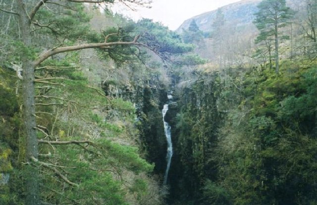
![]() This spectacular beauty spot is 1.5 km long and 60 metres deep cutting through a Highland wilderness rich in flora and fauna. The River Droma runs through the gorge, dropping dramitcally through a series of waterfalls, including the 46 metre Falls of Measach.
This spectacular beauty spot is 1.5 km long and 60 metres deep cutting through a Highland wilderness rich in flora and fauna. The River Droma runs through the gorge, dropping dramitcally through a series of waterfalls, including the 46 metre Falls of Measach.
The gorge was formed at the end of the last ice age and can be viewed from a viewing platform and a Victorian suspension footbridge. The walk below takes you past the gorge and through Braemor Wood to Lael Forest Garden with its 200 different tree species and longer plantation section with waterfalls.
Corrieshalloch Gorge is located about 12 miles south of Ullapool where you can climb to the viewpoint at Ullapool Hill and catch the ferry over to Stornoway in the Outer Hebrides.
Postcode
IV23 2PJ - Please note: Postcode may be approximate for some rural locationsCorrieshalloch Gorge Ordnance Survey Map  - view and print off detailed OS map
Corrieshalloch Gorge Open Street Map  - view and print off detailed map
*New* - Walks and Cycle Routes Near Me Map - Waymarked Routes and Mountain Bike Trails>>
Corrieshalloch Gorge OS Map  - Mobile GPS OS Map with Location tracking
Corrieshalloch Gorge Open Street Map  - Mobile GPS Map with Location tracking
Further Information and Other Local Ideas
To the west there's the expansive Loch Maree where you can visit the Victoria Falls and try the circular Beinn Eighe Mountain Trail. There's also the splendid Victoria Falls to visit next to the loch. The rushing falls are named after Queen Victoria who visited the site in 1877. Near here there's also Loch Gairloch where you can pick up the Gairloch Waterfall Walk in the lovely Flowerdale Glen.
At nearby Loch Broom there's another hidden gem at the delightful Ardessie Falls in the Ardessie Burn gorge.
Head west and you could visit the village of Poolewe and enjoy a stroll around the beautiful Inverewe Garden. The lochside gardens are a lovely place for a stroll with some nice footpaths taking you to subtropical plants, fine lawns and beautiful flowers. You can also enjoy fine views over Loch Ewe in this scenic area.
For more walking ideas in the area see the Scottish Highlands Walks page.
Cycle Routes and Walking Routes Nearby
Photos
Corrieshalloch Gorge. Off the A835, this gorge is a few minutes walk from the car park. Seen here from the end of the trail on the other side of the bridge.
The gorge is renowned for its lush vegetation, which thrives in the humid microclimate created by the steep-sided ravine. Ferns, mosses, and liverworts blanket the rocky walls, while wildflowers such as primroses, wood anemones, and bluebells bring seasonal bursts of colour to the area. Birch, rowan, and hazel trees line parts of the gorge, creating a beautiful canopy that contrasts with the exposed rock formations.
Corrieshalloch gorge viewing platform. Don't walk out onto it unless you have a good head for heights!
Birdlife in the gorge is vibrant, with species such as dippers and grey wagtails often spotted near the fast-flowing waters of the River Droma. Buzzards and kestrels are also seen soaring above the gorge, taking advantage of the thermals. Red deer are common in the surrounding woodlands and moorland, and if you're lucky, you might spot a pine marten or hear the call of a cuckoo during spring.
Bridge over the Gorge. The suspension bridge over the ravine.
The gorge, carved during the last Ice Age, is a geological wonder and one of the best examples of a box canyon in Scotland. The combination of cascading water, sheer cliffs, and verdant vegetation creates a breathtaking experience, making it a must-visit destination for nature enthusiasts and walkers alike.


