Cuckoo Way
![]()
![]() This walk follows the Chesterfield Canal through Nottinghamshire, South Yorkshire and Derbyshire from Chesterfield to West Stockwith. You will pass 36 locks and 11 bridges as you walk along one of England's most beautiful waterways.
This walk follows the Chesterfield Canal through Nottinghamshire, South Yorkshire and Derbyshire from Chesterfield to West Stockwith. You will pass 36 locks and 11 bridges as you walk along one of England's most beautiful waterways.
The walk passes Stavely, Retford and Worksop while there is also a pleasant section around the lovely Rother Valley Country Park at Killamarsh. Here you will find 5 lakes and a nature reserve which boasts the recording of over 260 different varieties of birds over the past two decades. Just south of Rother Valley Country Park you will pass the splendid Renishaw Hall at Eckington's. Here you will find a large country house surrounded by beautiful gardens, parkland, woodland and lakes.
Around Retford the splendid Idle Valley Nature Reserve is well worth a small detour.
The huge site has miles of walking trails with several lakes and hundreds of species of wetland bird to look out for.
Please click here for more information
Cuckoo Way Ordnance Survey Map  - view and print off detailed OS map
Cuckoo Way Open Street Map  - view and print off detailed map
Cuckoo Way OS Map  - Mobile GPS OS Map with Location tracking
Cuckoo Way Open Street Map  - Mobile GPS Map with Location tracking
Pubs/Cafes
On the route you could stop off for refreshments at The Boat Inn in Hayton. The pub is located right next to the canal and includes a nice outdoor area with views over the water. You can find the pub at 97 Main Street, Hayton with a postcode of DN22 9LF for your sat navs.
Near to Retford is The Hop Pole. It's in another fine spot next to the canal with a lovely beer garden. You can find it on Welham Road with a postcode of DN22 6UG. The pub is also dog friendly if you have your canine friend with you.
Further Information and Other Local Ideas
In Retford you can stop and see the Mayflower Pilgrims Visitor Centre in the town. Here you can learn about the Pilgrim Fathers, who originated from villages of Babworth and Scrooby on the outskirts of East Retford between 1586 and 1605. The Pilgrims were the English settlers who came to North America on the Mayflower and established the Plymouth Colony in what is today Plymouth, Massachusetts.
Cycle Routes and Walking Routes Nearby
Photos

The Cuckoo Way footpath follows the Chesterfield Canal through Wiseton and under Top Bridge

The footpath and Chesterfield canal by Gray's Bridge at Clayworth

Mere by the footpath. The mere is in an area of derelict land on the edge of the former iron works site which is being redeveloped for housing.

From the River Trent the Cuckoo Way takes it name from a type of boat that once worked on the Chesterfield Canal. Before it meets the Chesterfield Canal this path follows the line of a former canal branch.

Area of woodland just north of Renishaw on the Cuckoo Way. The path gets overgrown further on and appears to be very lightly trafficked.

Canal Bridge, Retford
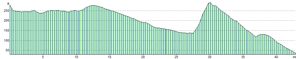
Elevation Profile