Derwent Valley Heritage Way Walks and Cycling
![]()
![]() Follow the River Derwent through the Derbyshire Peak District on this stunning walk. The path runs from Derwent Mouth, Shardlow and passes through Derby, Belper and Matlock on your way to the finish point at Ladybower Reservoir, Heatherdene.
Follow the River Derwent through the Derbyshire Peak District on this stunning walk. The path runs from Derwent Mouth, Shardlow and passes through Derby, Belper and Matlock on your way to the finish point at Ladybower Reservoir, Heatherdene.
Highlights on the route include a lovely section along the Cromford Canal from Cromford to Ambergate. You'll also pass the splendid Chatsworth Park with its 1000 acres of parkland with woodland trails and fallow deer. At Matclock you will pass High Tor hill where you can enjoy some wonderful views over the surrounding area.
The hill also includes the exciting narrow walkway of Giddy Edge.
Several sections along country lanes and the canals are also suitable for cycling. There's a nice surfaced path in Derby along the river which is also good for any type of cycle.
The walk is waymarked with a yellow arrow on a purple disc. Scroll down for the full GPX file for the route.
Derwent Valley Heritage Way Ordnance Survey Map  - view and print off detailed OS map
Derwent Valley Heritage Way Open Street Map  - view and print off detailed map
*New* - Walks and Cycle Routes Near Me Map - Waymarked Routes and Mountain Bike Trails>>
Derwent Valley Heritage Way OS Map  - Mobile GPS OS Map with Location tracking
Derwent Valley Heritage Way Open Street Map  - Mobile GPS Map with Location tracking
Pubs/Cafes
Head to Wheatcroft’s Wharf at Cromford Mills for some lovely canalside refreshments. There's several tables right next to the water making it the ideal spot to relax on a fine day. They have a good menu with fresh ‘made to order’ food from oven baked potatoes to homemade soup, Paninis, Pizza, summer salads or a simple sandwich.
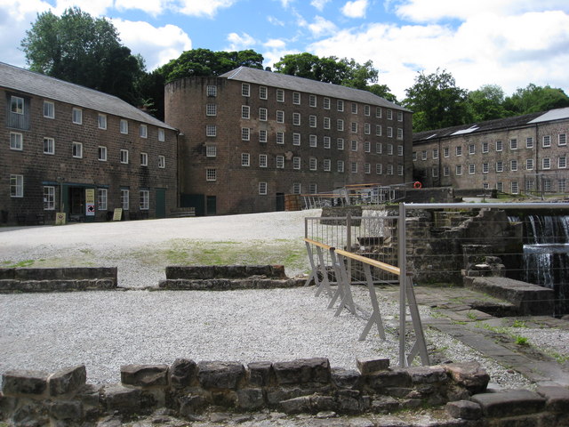
The site is also worth spending some time at with a wealth of information on this area. Cromford Mill is the home of Sir Richard Arkwright’s first mill complex, birthplace of the modern factory system and internationally recognised as a UNESCO World Heritage Site. Inside the centre there's interactive displays, games and puzzles that tell the story of how the valley changed the world in the 18th Century with the growth of the British cotton industry and its global impact. You can find the site at a postcode of DE4 3RQ for your sat navs.


Pictured above the Arkwirght Mill and the cafe at Cromford Mills.
In Rowsley there's The Peacock. The fine hotel includes a restaurant which has been awarded three AA rosettes. The hotel dates from the 1830s and is part of the Haddon Estate, owned by Lord and Lady Edward Manners who live at nearby Haddon Hall. At The Peacock there's also an informal bar area with an open fire and a good lunch menu. They have a lovely garden area and are located in a fine spot close to the river in the village. You can find them on Bakewell Road at postcode DE4 2EB for your sat navs. Rowsley is also home to the modern Peak Shopping Village. Here you'll find a good range of stores with plenty of eateries for refreshment.
In Little Eaton there's a few options including the New Inn. They do a fine Sunday lunch and have a pleasant garden area to relax in. You can find them at postcode DE21 5DR for your sat navs.
Cycle Routes and Walking Routes Nearby
Photos
Approaching the picnic area from Heatherdene Car Park at Ladybower Reservoir. The Derwent Valley Heritage Way offers a rich tapestry of natural life as it winds through a variety of habitats along the river. Walking along the path, you are treated to ancient woodlands, open meadows and riparian strips that burst into life with seasonal wildflowers such as bluebells, primroses and native orchids in spring, while ferns, mosses and liverworts thrive in the damp, shaded understoreys. Mature oaks, ash and beech trees form a stately canopy that supports a host of epiphytic lichens and other plants, and the hedgerows and grassy banks attract a myriad of butterflies, bees and other insects that help to pollinate the flora. Wildlife is abundant, with red squirrels darting among the branches, water voles and other small mammals making their homes near the river, and a diverse range of birds—from kingfishers and dippers to woodpeckers and finches—adding lively songs to the landscape.
DVH Way. Looking north, between Froggatt Edge and the River Derwent.
The River Derwent, a defining feature of the valley, rises in the high moorlands near Bleaklow and flows for about 50 miles through Derbyshire before joining the River Trent. Its clear, swift waters create essential riparian habitats that support fish such as trout, grayling and chub, and provide a home for otters and kingfishers. The river’s historical role in powering mills has left an indelible mark on the region’s industrial heritage, yet today its gentle flow and reflective surface continue to inspire tranquillity and offer recreational enjoyment for walkers, anglers and nature enthusiasts alike.
Picnic Area overlooking Ladybower Reservoir. The summit of Win Hill can be seen in the distance.
Cromford Canal The stretch just to the east of Leawood Aqueduct.The towpath now forms part of the Derwent Valley Heritage Way footpath. Crich Stand with the Sherwood Foresters memorial beacon can be seen in the distance.
Elevation Profile


