Dundee Walks - Dudhope Park and Dundee Law
![]()
![]() This walk visits the pretty gardens surrounding Dudhope Castle in Dundee. After exploring the gardens you can then head a short distance north to climb to Dundee Law for great views over the city. It's a nice way to visit two the cities highlights on a fairly short walk.
This walk visits the pretty gardens surrounding Dudhope Castle in Dundee. After exploring the gardens you can then head a short distance north to climb to Dundee Law for great views over the city. It's a nice way to visit two the cities highlights on a fairly short walk.
To continue your walking around Dundee you could head to the nearby Camperdown Park, Monikie Country Park, Crombie Country Park or Clatto Country Park.
Dundee Walks - Dudhope Park and Dundee Law Ordnance Survey Map  - view and print off detailed OS map
Dundee Walks - Dudhope Park and Dundee Law Open Street Map  - view and print off detailed map
Dundee Walks - Dudhope Park and Dundee Law OS Map  - Mobile GPS OS Map with Location tracking
Dundee Walks - Dudhope Park and Dundee Law Open Street Map  - Mobile GPS Map with Location tracking
Walks near Dundee
- Camperdown Park - Explore 400 acres of parkland in this large country park in Dundee
- Monikie Country Park - This country park near Dundee is perfect for a peaceful, scenic stroll
- Crombie Country Park - Explore the 200 acres of woodland surrounding the beautiful Crombie Loch in this country park near Arbroath, Angus
- Clatto Reservoir Country Park - Enjoy miles of well laid out cycling and walking trails in this lovely country park in Dundee
- Lairds Loch - This walk visits the pretty Lairds Loch in the Sidlaw Hills near Dundee.
- Newtyle Railway Walk - This circular walk in Angus takes you along the old Dundee and Newtyle Railway paths surrounding the village of Newtyle.
Further Information and Other Local Ideas
Head north west and you could visit the tranquil Lairds Loch and enjoy a climb to Northballo Hill in the lovely Sidlaw Hills.
To the north is the village of Newtyle where you can pick up the Newtyle Railway Walk along the old Dundee and Newtyle Railway.
Photos
Dudhope castle. Dudhope was the home of the Scrimegour family, hereditary standard bearers to the Kings of Scots. It is a 17th-century courtyard castle, extended from a 16th-century keep, which has now been demolished. The property was sold by the family in 1668, to John Graham of Claverhouse, also known as Bonnie Dundee or Bloody Cavers - depending on whose side you were on. He led the Jacobites to victory at Killiecrankie in 1689, though died in the process. The castle was later converted to use as a woollen mill, then a barracks. It was restored in 1989, and is now a part of the University of Abertay.
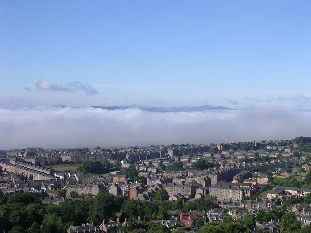
Fog in the Tay estuary. This view south from the summit of Dundee law shows a temperature inversion in the river estuary. Normally it is possible to see across the river to Fife. On this June morning cold air had crept from the sea into the river mouth (not an uncommon event especially in summer when sea haar spoils many a fine day in Dundee) and only a tiny fragment of Fife is visible above it.
As the sun rises, a haar (coastal fog) can be seen on the River Tay, approaching Dundee. Taken from the Law in late 1998. Shortly after this was taken, the haar hit the city itself. (Note that the Overgate Centre seems to be missing- you can see right through to the church tower and Nethergate- so I'm guessing this between the old one being demolished and the new one being built, as the crane would suggest).


