Ebury Way Walk and Cycle
![]()
![]() This is an easy short cycle and walking route ideal for families. It runs along National Cycle route 61 and a dismantled railway line from Rickmansworth to Watford and passes through a variety of habitats, including open moor, woodland, and wetlands. The trail crosses a number of waterways including the rivers Colne, Chess and Gade and the Grand Union Canal.
This is an easy short cycle and walking route ideal for families. It runs along National Cycle route 61 and a dismantled railway line from Rickmansworth to Watford and passes through a variety of habitats, including open moor, woodland, and wetlands. The trail crosses a number of waterways including the rivers Colne, Chess and Gade and the Grand Union Canal.
See the National Cycle Route 61 page for details of the full route which runs from Maidenhead to Hoddesdon.
Ebury Way Ordnance Survey Map  - view and print off detailed OS map
Ebury Way Open Street Map  - view and print off detailed map
*New* - Walks and Cycle Routes Near Me Map - Waymarked Routes and Mountain Bike Trails>>
Ebury Way OS Map  - Mobile GPS OS Map with Location tracking
Ebury Way Open Street Map  - Mobile GPS Map with Location tracking
Pubs/Cafes
At the start of the trail at Batchworth Lock you can enjoy some refreshments at the Cafe at Lock 81. They have a variety of sandwiches, hot food, hot and cold drinks, chocolate, crisps and sweets. There's also the adjacent Canal Centre with a wealth of information and the excellent Little Union Canal. This miniature working model canal shows how a lock and canal works. You can find the cafe at 99 Church St with a postcode of WD3 1JJ for your sat navs.
Dog Walking
It's a nice walk to do with your dog but please keep them under close control as there are often a lot of cyclists on the path. The Cafe at Lock 81 mentioned above is also dog friendly.
Further Information and Other Local Ideas
The Colne Valley Trail runs from Uxbridge to Rickmansworth. It's a good option for continuing your walking or cycling in the area. It runs on waterside paths and also passes a series of pretty lakes. The Celandine Route also runs just to the east of the trail. It will take you along the River Pinn from Pinner to Cowley.
Part of the trail runs along the Croxley Green Boundary Walk. This waymarked circular walk explores the area around the worthy village, visiting the canal and the River Gade on the way. You'll pass the southern edge of the trail as you pass Watford and Rickmansworth.
For more walking ideas in the area see the London Walks page.
Cycle Routes and Walking Routes Nearby
Photos

On the trail at Watford with autumn leaves on the path in October 2008. follows the trackbed of the long dismantled railway line from Watford to Rickmansworth. Opened in 1862, it was shortly afterwards taken over by the London & North Western Railway, but was an early victim of the post-war Nationalization of the railways, closing to passenger traffic in 1952. It now forms sections of both National Cycle Network Routes 6 (London to Keswick) and 61 (Rickmansworth to Ware).

The trail viewed looking west towards the A4145 Tolpits Lane bridge and then to Rickmansworth. The blue sign has a wildly overoptimistic distance of Ľ mile to Cassiobury Park and Watford Met Line Station. The very nearest point in the park is at least 1 mile away and the station at least a Ľ mile beyond that!

Croxley. Ebury Way viewed looking west under the Metropolitan Line bridge towards Rickmansworth, with a southbound underground train about to cross. Beyond the natural features, the Ebury Way also has historical interest as it follows part of the old Watford to Rickmansworth railway line, which was closed in the 1960s. The path offers pleasant views of the surrounding countryside and beyond to the nearby Croxley Green and the larger Colne Valley Regional Park. The route makes for a pleasant walk or bike ride, with good connections to local public transport and nearby attractions, such as the nearby Cassiobury Park, providing ample opportunities for exploring more green spaces in Watford.

Viewed looking west towards Rickmansworth from north of the Vale Industrial Estate. As an old railway trackbed, the path passes through a mix of habitats, from urban edges to more green, open areas. The hedgerows along the path are filled with native plants, including dog roses, blackberries, and hawthorn. Wildflowers such as buttercups, clover, and red campion add splashes of colour in the warmer months, while in some spots, more recent plantings of wildflower mixes can also be seen, attracting pollinators like bees and butterflies. In terms of fauna, walkers on the path may spot various bird species such as robins, warblers, and wood pigeons flitting through the underbrush. The area is also home to mammals like squirrels and hedgehogs, as well as evidence of foxes and smaller creatures that make use of the corridor between built-up areas.

River Colne from Ebury Way, Watford

River Colne from Ebury Way, Watford. This is the reverse view from the first geograph in this square, and shows the River Colne flowing away southwards from Ebury Way towards Hampermill. Note the heron and the pillbox if you can see them!
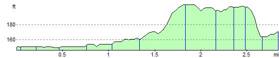
Elevation Profile