River Erme Plym Trail with OS Map
![]()
![]() Follow the Erme - Plym trail from Ivybridge to Laira Bridge on the outskirts of Plymouth on this pleasant walk through Devon. The route runs for about 17 miles on fairly flat paths with fine views over the Dartmoor National Park.
Follow the Erme - Plym trail from Ivybridge to Laira Bridge on the outskirts of Plymouth on this pleasant walk through Devon. The route runs for about 17 miles on fairly flat paths with fine views over the Dartmoor National Park.
You start on the River Erme in Ivybridge and follow the river to south Ermington before heading west to Yealmpton via Flete and Butland Wood.
The route continues through Brixton and Combe before arriving at the outskirts at Plymouth where you will pass the lovely Hooe Lake before finishing on Laira Bridge over the River Plym.
Erme Plym Trail Ordnance Survey Map  - view and print off detailed OS map
Erme Plym Trail Open Street Map  - view and print off detailed map
*New* - Walks and Cycle Routes Near Me Map - Waymarked Routes and Mountain Bike Trails>>
Erme Plym Trail OS Map  - Mobile GPS OS Map with Location tracking
Erme Plym Trail Open Street Map  - Mobile GPS Map with Location tracking
Pubs/Cafes
In Yealmpton you could enjoy some refreshment at the Rose and Crown. There's a cosy interior here with a roaring fire and a sun trap garden outside. They have a restaurant selling high quality food and also provide accommodation if you'd like to stay in the area. You can find them on Market Street at postcode PL8 2EB for your sat navs. The pub is dog friendly if you have your four legged friend with you.
In the village you can also visit the 400 year old Mother Hubbard's Cottage. The lady from the nursery rhyme lived in the cottage when working as the housekeeper at Kitley House.
Further Information and Other Local Ideas
At Hollacombe Hill you could take a detour south to visit the lovely coastline and beaches at Wembury Point. There's a marine reserve here with a variety of sea birds and some of the most significant rock pools in the country.
Photos

This part of the trail is just after Yeolands,heading towards Lower Keaton.

The trail leaves the A379 via this stile and crosses a field, not using a public right of way as such. On the left, a track curves towards Sequer's Bridge Quarry.

Gates on the Erme-Plym Trail The trail passes through the left-hand gate. The right-hand gate leads into a field shaped like a harp.

Dog Notice by the Erme-Plym Trail

Old barn by the trail. Left of centre, a small derelict barn has developed a rounded crown of ivy. Seen from the Erme-Plym Trail as it follows the flood plain of the River Erme downstream.

Gate near Modbury Cross By a track followed by Holbeton Bridleway 5. The Erme-Plym Trail leaves the bridleway to cross this field a metre or two to the left of the gate.

Meadow by the trail. Looking through a fringe of trees and across a ditch that borders the trail. This irregularly-shaped field is surrounded by drains. In the distance rises Ugborough Beacon.

Brixton: village edge, by Footpath 10 which enters the village at the end of Woodland Drive, a mix of Cornish units and more recent housing
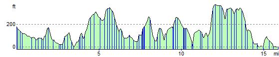
Elevation Profile