Flitch Way
![]()
![]() The Flitch Way is a cycle and walking route running along a decomissioned railway line through Essex. Starting in Bishop's Stortford, the path takes you through Hatfield Forest and the town of Great Dunmow to Braintree.
The Flitch Way is a cycle and walking route running along a decomissioned railway line through Essex. Starting in Bishop's Stortford, the path takes you through Hatfield Forest and the town of Great Dunmow to Braintree.
Highlights include the Victorian railway stations dotted along the path, deer in Hatfield Forest Country Park and views of the River Chelmer near Great Dunmow.
Flitch Way Ordnance Survey Map  - view and print off detailed OS map
Flitch Way Open Street Map  - view and print off detailed map
Flitch Way OS Map  - Mobile GPS OS Map with Location tracking
Flitch Way Open Street Map  - Mobile GPS Map with Location tracking
Pubs/Cafes
On the route you can stop off for refreshments at the Booking Hall Cafe at Rayne Station. The cafe also houses a free museum with information and old photos about the history of the railway. You can find the station at Station House Road, Rayne with a postcode of CM77 6RX for your sat navs.
In Great Dunmow there's The Angel and Harp. They have a nice interior with with oak beams and red brick fireplace. They serve good quality food and have a nice garden area to sit out in too. You can find them at 16 Church Street, CM6 2AD.
Dog Walking
The trail is popular with dog walkers you'll probably see plenty of other owners as you make your way along the path. The cafe mentioned above is also dog friendly. Hatfield Forest, on the route, is another good spot to take your dog with lots of fine woodland trails.
Further Information and Other Local Ideas
Near Braintree you'll pass Great Notley Country Park where there's some good cycling and walking trails to try. The 100 acre park is just south of the route and has wetland areas and a lake.
Cycle Routes and Walking Routes Nearby
Photos

Flitch Way Country Park. Braintree station.

View of the former Bishop’s Stortford to Braintree branch railway, now converted to a footpath. Looking towards the former Takeley station from Canfield Road.

Rayne Station Centre - Flitch Way Country Park. The former Rayne Railway Station is now the Visitor Centre for the Country Park.
The line was part of a series of projects proposed in the 19th century, aiming to establish north-south connections linking Great Dunmow with Epping, Halstead, and/or Saffron Walden. Initially proposed by the Eastern Counties Railway (ECR) in 1859, the route was eventually constructed by the Great Eastern Railway (GER), which had absorbed the ECR. Construction commenced in 1864, and the line became operational on 22 February 1869, serving Takeley, Felstead, and Rayne. Easton Lodge was added to the route in 1894, followed by Hockerill in 1910, and StaneStreet and Bannister Green in 1922.

Just beside the Rayne Station Centre, is a "Rowe Type" Milepost (designed by Welsh artist Andrew Rowe) giving distances to places along the route and a circular disc. This is part of something called the "Millennium Time Trail" - a complex series of puzzles that you can solve by taking 'rubbings' from different mileposts. The Time Trail, including discs, was devised and designed by Charlie Harrow.
.jpg)
Takeley Station. This view of the disused railway line is taken looking toward Braintree. The railway line operated as a single track with passing loops strategically placed at Bishop's Stortford, Dunmow, Takeley, Rayne, and Braintree. Additionally, goods sidings were established at various points, including Hockerill Halt, Takeley, and Easton Lodge, to cater to the needs of US Air Force bases at Stansted and Easton Lodge. Other goods sidings were located at Dunmow and Felsted, primarily serving general purposes and facilitating transportation for the nearby sugar beet factory at Rayne.

Bluebell Wood. This is Runnel's Hey which lies beside the former railway trackbed.

River Chelmer near the trail. A viaduct spanning the River Chelmer to the south of Great Dunmow was dismantled during the 1970s to accommodate the construction of the A1256 Great Dunmow bypass. Initially, passenger traffic on the railway line was relatively robust upon its opening. However, increased competition from bus and road transportation led to dwindling train occupancy, with trains operating nearly empty by the time passenger services ceased on 3 March 1952. Although the line continued to operate for freight purposes until the end of 1971, it eventually shut down entirely in 1972.

Bridge carrying the trail over Notley Road
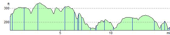
Elevation Profile