Forest Way -Essex
![]()
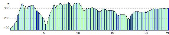
![]() The Forest Way in Essex runs from Loughton station to Hatfield Forest.
The Forest Way in Essex runs from Loughton station to Hatfield Forest.
The walk starts at the town of Loughton, taking you through Epping Forest and Epping Green towards Harlow where you pass through Harlow Common. The route continues north passing Hatfield Heath and Woodside Green before finishing at the lovely Hatfield Forest Park with its resident deer. Around Hatfield Forest you can link up with the Flitch Way which runs towards nearby Great Dunmow.
Forest Way -Essex Ordnance Survey Map  - view and print off detailed OS map
Forest Way -Essex Open Street Map  - view and print off detailed map
Forest Way -Essex OS Map  - Mobile GPS OS Map with Location tracking
Forest Way -Essex Open Street Map  - Mobile GPS Map with Location tracking
Further Information and Other Local Ideas
In Harlow you could pick up the Harlow Walk which starts from the Harlow Town train station. It uses part of the Stort Valley Way to explore the river and the pretty Pishiobury Park in Sawbridgeworth. There's also a nice riverside pub at the end of the walk to visit.
For more walking ideas in the area see the Essex Walks page.
Cycle Routes and Walking Routes Nearby
Elevation Profile