Foel Fras
![]()
![]() Climb to the summit of Foel Fras on this challenging climb in the Carneddau mountain range in the Snowdonia National Park.
Climb to the summit of Foel Fras on this challenging climb in the Carneddau mountain range in the Snowdonia National Park.
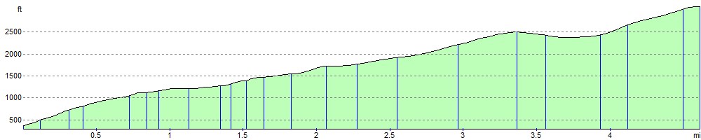
The walk starts from the pretty seaside town of Llanfairfechan and climbs towards Garreg Fawr along the North Wales Coast Path. You continue to Pen Bryn Du before reaching the 770 m (2,526 ft) of Drum. From Drum you climb to Foel Fras with wonderful views down towards the pretty Llyn Anafon below. The summit of Foel Fras stands at 942 m (3,091 ft) making it one of the Welsh 3000s (mountains over 3000ft high). From the high pint there are wonderful views over Carneddau and the rest of Snowdonia.
This route descends straight back to LLanfairfechan but you have other options if you'd like to extend your walk. You could continue south and climb to Carneddau Llewellyn, the second highest peak in Wales after Snowdon. This would take you past Garnedd Uchaf and Foel Grach. You could also descend back to Drum and head east to visit Pen Y Castell.
As an alternative you can start the walk from the beautiful Aber Falls by heading left from the car park along the North Wales Coast Path towards Garreg Fawr. Then follow this route from there.
Foel Fras Ordnance Survey Map  - view and print off detailed OS map
Foel Fras Open Street Map  - view and print off detailed map
Foel Fras OS Map  - Mobile GPS OS Map with Location tracking
Foel Fras Open Street Map  - Mobile GPS Map with Location tracking
Pubs/Cafes
Back in LLanfairfechan head to the Virginia Inn for some well earned refreshments after your walk. There a good selection of ales and beer garden to relax in on fine days. You can find the pub in the town centre at postcode LL33 0TH for your sat navs.
Further Information and Other Local Ideas
The walk is accessible by public transport from Llanfairfechan railway station which is located on the Crewe to Holyhead North Wales Coast Line.
The circular Llanfairfechan Walk also starts from the town and heads along the Wales Coast Path before climbing to Conwy Mountain for more great views.
For more walking ideas in the area see the Snowdonia Walks page.
Cycle Routes and Walking Routes Nearby
Photos
.jpg)
Llanfairfechan

The southern slopes of Foel Fras

The Graveyard Slope of Foel Fras. This, the eastern slope of Foel Fras, is dotted with WWII air crash sites. Such were the number of air accidents between here and Foel Grach that the area was dubbed 'The Graveyard' by RAF Llandwrog's MR team.

Looking across Cwm Penamnen and the Southern end of the plantation at Foel-fras.

Llwytmor from Foel Fras Summit. The summit of Foel Fras looking Northwest to Llwytmor beyond

View north, down the north slopes of Foel Fras to Llyn Anafon and Ynys Seiriol.

The Western flank of Foel-fras, with Bera Bach and Bera Mawr beyond.

Trig-point and summit shelter
Elevation Profile