Green Street Green Circular Walk
![]()
![]() This short circular walk takes you through the woodland, parkland and countryside around Green Street Green in Bromley. The walk visits Pratts Bottom, Chelsfield and the splendid High Elms Country Park. It runs for just over 7 miles with a few small climbs on the way.
This short circular walk takes you through the woodland, parkland and countryside around Green Street Green in Bromley. The walk visits Pratts Bottom, Chelsfield and the splendid High Elms Country Park. It runs for just over 7 miles with a few small climbs on the way.
The park boasts 250 acres of countryside including a 150 acre golf course, woodlands, a nature centre, an ice well, formal gardens and wildflower meadows. You can also pick up the Cudham Circular Walk and the epic London Loop here.
Good access points for the walk are Chelsfield railway station or the nearby car park.
Green Street Green Circular Ordnance Survey Map  - view and print off detailed OS map
Green Street Green Circular Open Street Map  - view and print off detailed map
Green Street Green Circular OS Map  - Mobile GPS OS Map with Location tracking
Green Street Green Circular Open Street Map  - Mobile GPS Map with Location tracking
Pubs/Cafes
Back in the village The Rose and Crown is a good choice for post walk refreshment. They do a fine Sunsay roast which you can enjoy in the lovely large garden. You can find them at postcode BR6 6BT for your sat navs.
Dog Walking
The country and woodland trails make for a fine dog walk and the Rose and Crown mentioned above is also dog friendly.
Further Information and Other Local Ideas
Hayes Common and Keston Common are nearby. Both have some nice easy trails to try.
For more walking ideas in the area see the London Walks page.
Cycle Routes and Walking Routes Nearby
Photos

Green Street Green village sign. At the junction of Sevenoaks Road and Farnborough Hill. The sign depicts the symbol of Kent and the brewery that once stood nearby.

Green Street Green Roundabout. Junction of the 1920s A21 Farnborough Way with two of its predecessors as the main route to Sevenoaks and beyond: what is now Green Street Green High Street and prior to that Old Hill. Two pubs stand here: on the left is the Rose and Crown and on the right is the Royal Oak.

The Green, Green Street Green

Footpath to Green Street Green

The Ship Green Street Green, 2006. It's Sunday lunchtime, and quite a few customers have already arrived at this popular pub and restaurant at the junction of the B260 and B262, as a horse rider passes. The Dutch-gabled cottages beyond are not connected with the pub. The name 'Green Street Green' is not unique to this village: there is another Green Street Green just a few miles away on the A21, and still in Kent.

Formal Garden in High Elms Country Park Known as the Lubbock Garden, due to the original owners of the estate that now is the High Elms Country Park. For more info on Sir John Lubbock.

Chelsfield Green. This strip of grassland alongside Warren Road links the development around Chelsfield Station with the old village of Chelsfield. It gives a wide view to the north across south and east London

Pratt's Bottom Common, May 2008. The bunting is in place for the Pratt's Bottom Fete, due to take place the following day.
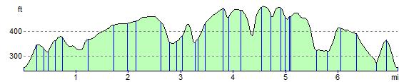
Elevation Profile
GPS Files
GPX File
Green Street Green Circular.gpx (On Desktop:Right Click>Save As. On Ipad/Iphone:Click and hold>Download Linked File)NB GPS file for this route only details route start - route is waymarked from there in