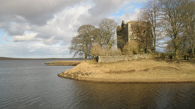
Harperrig Reservoir
![]()
![]() This walk visits Harperrig Reservoir in West Lothian near the Pentland Hills. There's nice easy footpaths running along the tranquil waters with fine views to the surrounding countryside and hills.
This walk visits Harperrig Reservoir in West Lothian near the Pentland Hills. There's nice easy footpaths running along the tranquil waters with fine views to the surrounding countryside and hills.
You can start the walk at the car park at the western side of the water. Here you can enjoy views of the Water of Leith and the ruins of Cairns Castle which dates back to 1440.
The area is also good for wildlife spotting with various wildfowl and the Eurasian otter to look out for.
The Cross Borders Drove Road runs past the eastern end of the lake. You could pick up this long distance footpath to continue your walk. It runs south through the Pentland Hills to West Linton, Peebles, Traquair and then on to Hawick via the Yarrow Valley.
Postcode
EH27 8DH - Please note: Postcode may be approximate for some rural locationsHarperrig Reservoir Ordnance Survey Map  - view and print off detailed OS map
Harperrig Reservoir Open Street Map  - view and print off detailed map
Harperrig Reservoir OS Map  - Mobile GPS OS Map with Location tracking
Harperrig Reservoir Open Street Map  - Mobile GPS Map with Location tracking
Further Information and Other Local Ideas
A few miles to the west you'll find more nice trails around Cobbinshaw Reservoir.
If you head towards Edinburgh there's Harlaw Reservoir and Threipmuir Reservoir. Here you'll find a visitor centre and circular footpath around the reservoir. To the east of here there's the Flotterstone Glencorse Reservoir and the climb to the viewpoint at Scald Law.
Head north towards Livingston and there's the pretty Eliburn Reservoir in Eliburn Park.
To the north west there's a nice short, easy walk to the picturesque Linn Jaw Waterfall.
For more walking ideas in the area see the Pentland Hills Walks page.
Cycle Routes and Walking Routes Nearby
Photos
Baad Park and Harperrig reservoir. The reservoir was created in 1860 as part of a scheme to improve the supply of drinking water to Edinburgh.


