Ingram Valley

 This walk takes you on a tour of the beautiful Ingram River Breamish Valley in the Northumberland National Park. You'll pass along rivers and burns with miles of open moorland and the Cheviot Hills making a splendid backdrop.
The walk starts at the village of Ingram and heads west along the River Breamish and the Greensidehill burn towards Brough Law and Linhope. At Hartside you turn south and head towards Alnhamoor crossing the river as you go. You continue to Little Dod before picking up Salter's Road (a track) to climb High Cantle hill. You continue east towards Linhope where you can take a short detour to visit the splendid Linhope Spout waterfall. From Linhope you soon pick up the country lane from the start of the walk which will return you to Ingram.
If you'd like to continue your walks in the area then you could climb the nearby Hedgehope Hill and The Cheviot.
Postcode
NE66 4LU - Please note: Postcode may be approximate for some rural locationsIngram Valley Ordnance Survey Map  - view and print off detailed OS map
Ingram Valley Open Street Map  - view and print off detailed map
Ingram Valley OS Map  - Mobile GPS OS Map with Location tracking
Ingram Valley Open Street Map  - Mobile GPS Map with Location tracking
Pubs/Cafes
Head to the Ingram Cafe for some post walk refreshments. It's located very close to the start point for the walk and sells soups, toasties and cakes. They also have an interesting museum with fascinating local history covering thousands of years. There's plenty of seating inside and there's also an outdoor area for finer days. You can find the cafe in the village at a postcode of NE66 4LT for your sat navs. It's also dog friendly if you have your canine friend with you. Nearby you can also visit the 11th-century St Michael and All Angels village church. The historic church still holds services and is worth investigating.
Further Information and Other Local Ideas
The area is has a fascinating ancient history with many hillforts to look out for as you make your way through the area. There's also several Bronze Age burial cairns and faint circles on the ground signifying the remains of old timber roundhouses.
Head a few miles south east and you could explore the expansive Thrunton Woods where there are miles of peaceful woodland trails with views of the Cheviots. The woods sit next to the pretty village of Whittingham where you can enjoy views of the River Aln and see the noteworthy old church which dates back to the 10th century.
To the south there's the circular Shepherds Cairn Walk which visits a memorial to two shepherds who lost their lives in the exceptionally cold winter of 1962. The walk starts from Alnham where there's a noteworthy Grade I listed 12th century church.
Cycle Routes and Walking Routes Nearby
Photos

River Breamish, Ingram valley

Ingram Valley from cairn near Ewe Hill

Brough Law, Ingram Valley. Bridge crossing the River Breamish. Taken from Knock Hill.

Brandon, Ingram valley

Photo of the visitor centre in the village. This is the visitor centre for the National Park at Ingram, one of the gateways to the park from the east.

A view of the grassy hill and rocky outcrop at Great Standrop in the valley.
Located near Linhope

River Breamish near Ingram with a dipper on the rocks. The river rises on Comb Fell in on the southern side of The Cheviot. It becomes the River Till near Wooler; this is the only tributary of the River Tweed that flows exclusively in England.

The noteworthy 11th century church in the village
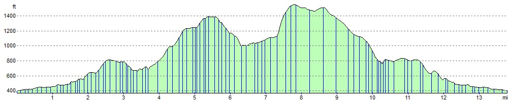
Elevation Profile