Linhope Spout Walk
![]()
![]() This short walk takes you to this lovely waterfall in the Ingram Valley. The walk starts at Hartside where there is parking available by the roadside. You then follow a country lane to Linhope where you cross the River Breamish and ascend to the waterfall and Linhope burn on public footpaths. The waterfall is an impressive 60 foot (18m) chute of water landing into a deep plunge pool below. On the walk there are splendid views of Great Standrop and Hedgehope Hill. Look out for Curlew and red squirrels on the way.
This short walk takes you to this lovely waterfall in the Ingram Valley. The walk starts at Hartside where there is parking available by the roadside. You then follow a country lane to Linhope where you cross the River Breamish and ascend to the waterfall and Linhope burn on public footpaths. The waterfall is an impressive 60 foot (18m) chute of water landing into a deep plunge pool below. On the walk there are splendid views of Great Standrop and Hedgehope Hill. Look out for Curlew and red squirrels on the way.
Our Ingram Valley and River Breamish Valley circular walks both pass close to the falls. For a longer walk you could start from the Ingram Bridge car park and follow either of these trails to Linhope. Back in Ingram there's the option of visiting the nice Ingram Cafe where there's a good range of meals and snacks to enjoy after your exercise.
If you'd like to continue your walking in the area then you could climb the nearby Hedgehope Hill and The Cheviot.
Postcode
NE66 4LZ - Please note: Postcode may be approximate for some rural locationsLinhope Spout Ordnance Survey Map  - view and print off detailed OS map
Linhope Spout Open Street Map  - view and print off detailed map
*New* - Walks and Cycle Routes Near Me Map - Waymarked Routes and Mountain Bike Trails>>
Linhope Spout OS Map  - Mobile GPS OS Map with Location tracking
Linhope Spout Open Street Map  - Mobile GPS Map with Location tracking
Pubs/Cafes
As mentioned above the Ingram Cafe is a great option. They do lovely home cooked food and also have an interesting museum with fascinating local history covering thousands of years. There's plenty of seating inside and there's also an outdoor area for finer days. You can find the cafe in the village at a postcode of NE66 4LT for your sat navs.
Dog Walking
The area is a nice place to take your dog for a walk. It's best to keep them on leads because of the sheep in the adjacent fields. The Ingram Cafe mentioned above is also dog friendly.
Further Information and Other Local Ideas
The area around Ingram has lots of ancient sites and wonderful viewpoints to visit. Head west from the village and there's a number of sites around Brough Lough and Hartside Hill. To the south there's Old Fawdon Hill and old forts at Castle Knowe and Gibb's Hill. More information can be gleaned from the display in the museum in Ingram which is well worth a visit.
Head a few miles south east and you could explore the expansive Thrunton Woods where there are miles of peaceful woodland trails with views of the Cheviots. The woods sit next to the pretty village of Whittingham where you can enjoy views of the River Aln and see the noteworthy old church which dates back to the 10th century.
To the south there's the circular Shepherds Cairn Walk which visits a memorial to two shepherds who lost their lives in the exceptionally cold winter of 1962. The walk starts from Alnham where there's a noteworthy Grade I listed 12th century church.
To the south west there's Davidson's Linn to visit. The picturesque and remote waterfall is situated on the Usway Burn and a lovely spot for a picnic and a paddle.
Cycle Routes and Walking Routes Nearby
Photos

Pool Below Linhope Spout. The force of the waterfall is quickly stilled and within 20 metres the burn forms this peaceful pool.

Linhope Spout

Linhope Burn above Linhope Spout. Lovely view of the surrounding countryside and hills taken during the late summer of 2009

Dunmoor Hill beside the falls

A view of a family walking along the path at the foot of Ritto Hill (380m).

A graceful 18m chute of water with a deep plunge pool below.
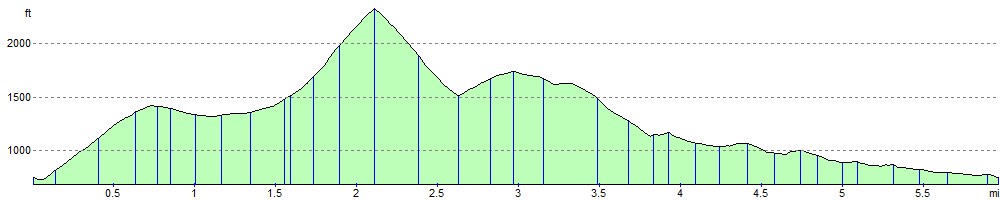
Elevation Profile