The Cheviot Walk
![]()
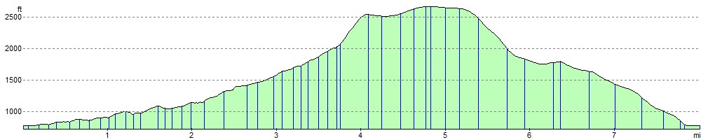
![]() This circular walk climbs to the 815 m (2,674 ft) summit of the highest hill in the Cheviot hills. The walk begins at the parking area at Langleeford by the Harthope Burn. The route then ascends along public footpaths and with the burn on your left. You continue to Cairn Hill passing the pretty Harthope Linn waterfall on the way. At Cairn Hill you pick up the Pennine Way to take you to the summit. This section takes place on stone slabs through an area of peat bog. At the summit you can enjoy excellent views of the North Sea, the Lake District Fells, Cross Fell and the Lammermuir Hills. You then descend back to Langleeford via Scald Hill.
This circular walk climbs to the 815 m (2,674 ft) summit of the highest hill in the Cheviot hills. The walk begins at the parking area at Langleeford by the Harthope Burn. The route then ascends along public footpaths and with the burn on your left. You continue to Cairn Hill passing the pretty Harthope Linn waterfall on the way. At Cairn Hill you pick up the Pennine Way to take you to the summit. This section takes place on stone slabs through an area of peat bog. At the summit you can enjoy excellent views of the North Sea, the Lake District Fells, Cross Fell and the Lammermuir Hills. You then descend back to Langleeford via Scald Hill.
If you'd like to continue your walking in the Cheviots you could climb Windy Gyle or pick up the Pennine Way.
The hill is also located close to the town of Wooler where you can enjoy some nice trails around Wooler Common. Near here you can pick up the Harthope Burn which will lead you to the start point for this walk at Langleeford.
Postcode
NE71 6RG - Please note: Postcode may be approximate for some rural locationsThe Cheviot Ordnance Survey Map  - view and print off detailed OS map
The Cheviot Open Street Map  - view and print off detailed map
*New* - Walks and Cycle Routes Near Me Map - Waymarked Routes and Mountain Bike Trails>>
The Cheviot OS Map  - Mobile GPS OS Map with Location tracking
The Cheviot Open Street Map  - Mobile GPS Map with Location tracking
Pubs/Cafes
A few miles to the north east there's the town of Wooler where you'll find a number of pubs and cafes. The Anchor Inn is a good choice with a friendly atmosphere and very good food at reasonable prices. You can find it on Cheviot Street with a postcode of NE71 6LN. It's also dog friendly if you have your canine friend with you.
Further Information and Other Local Ideas
A few miles to the north there's another popular climb to Yeavering Bell. There's a large Iron Age Hillfort and more fine views from the summit of this noteworthy hill. Near the fort there's the beautiful College Valley where you can enjoy waterside trails along the College Burn to the pretty Hethpool Linn waterfall.
To the south west there's Davidson's Linn to visit. The picturesque and remote waterfall is situated on the Usway Burn and a lovely spot for a picnic and a paddle.
For more walking ideas in the area see the Cheviots Walks page.
Cycle Routes and Walking Routes Nearby
Photos

The Cheviot. View south across Langleeford Vale, with Comb Fell on right.

Approaching the summit

Taken from the lower slope, looking down to Scald Hill with Wooler and, 18 miles away, the sea. The photo was taken on Dec 31st 2004, it was bitterly cold but absolutely clear

Causeway across the Cheviot plateau. The last kilometre or so of ascent from the Wooler direction has been made much easier by this stone causeway.

Just before the descent

Summit Pillar at 815m

Looking south over Coldburn Hill to The Cheviot.

From Dere Street towards the Cheviot. The stand of Scots Pine across the moor adds interest to the middle distance. The hill dominates the distant view.
Elevation Profile