Ketts Country Walk
![]()
![]() Follow Kett's Country Walk from Cringleford to Wymondham on this splendid walk through Norfolk. In 1549 Robert Kett led a movement which threatened the property owning classes. His journey from Wymondham to Norwich ended with the death of thousands of rebels in a pitched battle with 10,000 troops.
Follow Kett's Country Walk from Cringleford to Wymondham on this splendid walk through Norfolk. In 1549 Robert Kett led a movement which threatened the property owning classes. His journey from Wymondham to Norwich ended with the death of thousands of rebels in a pitched battle with 10,000 troops.
This walk follows in his footsteps and visits a number of interesting villages with historic churches. While there is some lovely countryside scenery on the walk it is the fascinating historical aspects which are most appealing.To continue your walking you can enjoy stroll the lovely Tiffey Valley in Wymondham. A riverside path leads north from the town, with lots of wildlife and wildlfowers to look out for on the way.
Ketts Country Walk Ordnance Survey Map  - view and print off detailed OS map
Ketts Country Walk Open Street Map  - view and print off detailed map
Ketts Country Walk OS Map  - Mobile GPS OS Map with Location tracking
Ketts Country Walk Open Street Map  - Mobile GPS Map with Location tracking
Pubs/Cafes
Just east of Cringleford you could visit The Red Lion. It's a historic pub of some note, dating all the way back to the 17th century. There's a charming interior with Dutch gables, beams, panelled walls and inglenook fireplaces. Parking is available and there's also a large garden to relax in on warmer days. You can find them at postcode NR4 7LD for your sat navs.
Further Information and Other Local Ideas
The route links up with the Tas Valley Way around Cringleford. The walk takes you along the River Tas to Attleborough and Old Buckenham where you can visit the historic castle ruins. Also in this area you can link with the Yare Valley Walk. The 6 mile trail visits the wildlife rich Marston Marshes Nature Reserve and heads through Cringleford to the man made broad in the pleasant grounds of the University of East Anglia.
Cycle Routes and Walking Routes Nearby
Photos
Ashwellthorpe railway station - the stationmaster's house. The large house seen in mid-distance used to be the stationmaster's house, the station building adjoins it. Ashwellthorpe station was opened by the GER (Great Eastern Railway), serving as a cut-off line between Forncett and Wymondham. It later became part of the London and North Eastern Railway. The station was closed to passenger traffic in 1939 and to freight in 1951. The originally single-track line was used for main line diversion trains during the floods of 1912 and it was doubled for military purposes during WWI. The two porters' cottages, the station master's house and the station building including a very short section of the former platform are still standing but have since been converted into private dwellings. An industrial site adjoins in the west.
Intwood Hall. The route passes the hall just south of Cringleford. Intwood Hall is a Grade II listed building dating from the 16th century. It has three brick walled enclosures, one with battlements, a central gateway and a terrace with 19th century summer house. The Hall is surrounded by parkland from which it is separated by a ha-ha. All Saints church stands on the eastern edge of its grounds. This view was taken from All Saints' churchyard.
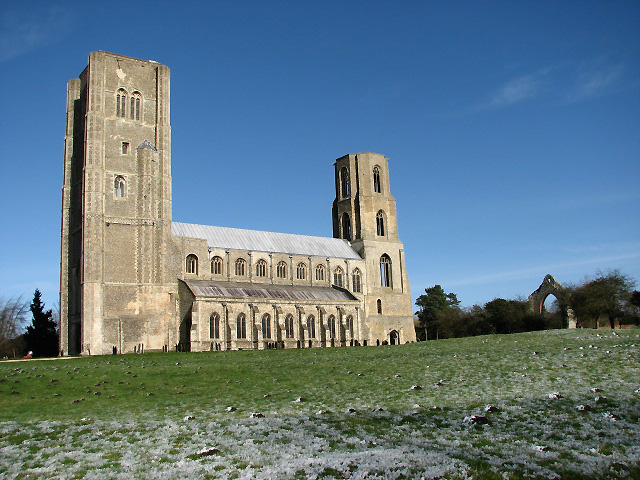
Wymondham Abbey. The church of St Mary & St Thomas of Canterbury, known as Wymondham Abbey, once used to be the church of a Benedictine Priory that once stood here. The Priory became an Abbey in 1448 but was closed by Henry VIII in the 1530s; its remains can still be seen in the adjacent field. The archway seen here (at right) used to be one of the doorways into the church. The church was completed during the 12th century. It used to be a cruciform church, with a length of 70 metres and twin west towers.
Elevation Profile

Video
GPS Files
GPX File
Ketts Country Walk.gpx (On Desktop:Right Click>Save As. On Ipad/Iphone:Click and hold>Download Linked File)NB GPS file for this route only details route start - route is waymarked from there in


