Lulworth Cove to Durdle Door Walk
![]()
![]() Take in two of the Jurassic Coast's most spectacular natural features on this short walk in Dorset. The walk starts at the picturesque village of West Lulworth where you will find rows of pretty cottages and the Castle Inn - one of the oldest pubs in Dorset dating from the 16th Century. The trail then takes you to the coast and the beautiful Lulworth Cove. This sheltered bay is enclosed almost in a circle and was formed 10,000 years ago by the combined forces of a river and the sea. Next to the cove you will pass the West Lulworth Heritage Centre which contains a museum about the coast and the village.
Take in two of the Jurassic Coast's most spectacular natural features on this short walk in Dorset. The walk starts at the picturesque village of West Lulworth where you will find rows of pretty cottages and the Castle Inn - one of the oldest pubs in Dorset dating from the 16th Century. The trail then takes you to the coast and the beautiful Lulworth Cove. This sheltered bay is enclosed almost in a circle and was formed 10,000 years ago by the combined forces of a river and the sea. Next to the cove you will pass the West Lulworth Heritage Centre which contains a museum about the coast and the village.
From the cove you follow the South West Coast Path west towards Durdle Door. This spectacular natural limestone arch also has an adjacent beach and caves. The walk then takes you back to West Lulworth along countryside walking trails.
There is ample parking at Lulworth Cove. If you are coming by public transport you could get the train to Wool and then a connecting bus to the cove.
The walk can be extended by heading a few miles west and visiting the beautiful Ringstead Bay and Osmington Mills on the longer Lulworth Cove to Osmington Mills Coastal Walk.
To visit the cove from the nearby resort of Swanage you can try the Swanage to Lulworth Cove Walk which also visits the nearby marine reserve at Kimmeridge Bay. You could also try the Lulworth Range Walks which visits the deserted village of Tyneham before heading along the coast at Brandy Bay and Worbarrow Bay.
Lulworth Cove to Durdle Door Ordnance Survey Map  - view and print off detailed OS map
Lulworth Cove to Durdle Door Open Street Map  - view and print off detailed map
Lulworth Cove to Durdle Door OS Map  - Mobile GPS OS Map with Location tracking
Lulworth Cove to Durdle Door Open Street Map  - Mobile GPS Map with Location tracking
Pubs/Cafes
Back in Lulworth village there's the thatched Castle Inn for some post walk refreshment. The historic 16th century inn includes a delightful terraced garden with splendid views. You can find the picture postcard pub in West Lulworth at a postcode of BH20 5RN for your sat navs.
You could also head to the Boat Shed Cafe. The Nautically themed cafe is located in a lovely spot right on the beach at the cove. They serve delicious cakes and a very fine cream tea.
Dog Walking
The coastal path is a fine one to do with your dog. Dogs are allowed on the beach all year to the left hand side of the slipway in Lulworth Cove. They are also allowed on the Durdle Door beach all year. The Castle Inn mentioned above is very dog friendly with water bowls provided for your thirsty friend.
Further Information and Other Local Ideas
Head a couple of miles inland and you could visit the historic Lulworth Castle. The castle dates back to the 17th Century and includes some beautiful grounds and gardens. Near here there's the Winfrith Newburgh Heath and Tadnoll Nature Reserves. The reserves include miles of peaceful heathland trails with lots of wildlife and a splendid viewpoint.
For more walking ideas in the area see the Dorset Walks page.
Cycle Routes and Walking Routes Nearby
Photos
The way to Durdle Door. The shape of the coastline surrounding Durdle Door is influenced by its geology, with the hardness of the rocks and local fault and fold patterns playing key roles. The arch has developed on a concordant coastline, where rock bands run parallel to the shoreline. The rock layers are nearly vertical, with narrow bands. Initially, a resistant band of Portland limestone ran along the shore, the same band seen further along the coast forming the narrow entrance to Lulworth Cove. Behind this lies a 120-metre band of softer, easily eroded rocks, followed by a stronger, thicker band of chalk forming the Purbeck Hills. These steeply dipping rocks are part of the Lulworth crumple, which is part of the broader Purbeck Monocline, formed during the mid-Cenozoic by the building of the Alps.
There is limited historical documentation about the arch, though its name likely originated over a millennium ago. Descriptions from the late 18th century refer to the "magnificent arch of Durdle-rock Door," while early 19th-century maps label it as "Duddledoor" or "Durdle" / "Dudde Door." In 1811, the first Ordnance Survey map called it "Dirdale Door." The term "Durdle" comes from the Old English word "thirl," meaning to pierce, bore, or drill, which is derived from "thyrel," meaning hole. Similar names in the area include Durlston Bay and Durlston Head to the east, as well as the Thurlestone, an arched rock in Devon to the west. The "Door" part of the name likely refers to the arched shape of the rock. In the late 19th century, it was even referred to as the "Barn-door" due to its size.
Durdle Door from above. The limestone and chalk are closer at Durdle Door compared to Swanage, where the distance is over 2 miles. Along this coastline, most of the limestone has been eroded by sea action, leaving the small headland containing the arch. Erosion at the western end of the limestone band led to the formation of the arch. UNESCO teams monitor the condition of both the arch and the adjacent beach.
The 120-metre isthmus connecting the limestone to the chalk consists of a 50-metre band of Portland limestone, a narrow band of compressed Cretaceous Wealden clays and sands, and then narrow bands of greensand and sandstone. In Man O' War Bay, the Portland and Purbeck limestone band has not been entirely eroded, visible above the waves as Man O'War Rocks. Offshore to the west, the eroded limestone forms a line of small rocky islets called The Bull, The Blind Cow, The Cow, and The Calf.
Given the erosive nature of the coastline, occasional rockfalls and landslides occur, with a significant slide occurring just east of Durdle Door in April 2013, impacting a portion of the South West Coast Path.
Durdle Door has served as a backdrop for various music videos, including Tears for Fears' "Shout," Billy Ocean's "Loverboy," Cliff Richard's "Saviour's Day," and Bruce Dickinson's "Tears of the Dragon." Additionally, the landscape around Durdle Door has been featured in several films, such as Wilde (1997), Nanny McPhee, and Far From The Madding Crowd (1967). In the Doctor Who episode "The Power of the Doctor" (2022), Durdle Door was where the Thirteenth Doctor regenerated into the Fourteenth Doctor. Moreover, Arthur Moule, a Dorset-born poet and missionary to China, wrote about Durdle Door in his 1879 book of poetry, Songs of Heaven and Home, expressing wonder at the timeless rhythm of the tides and the enduring presence of the arch.
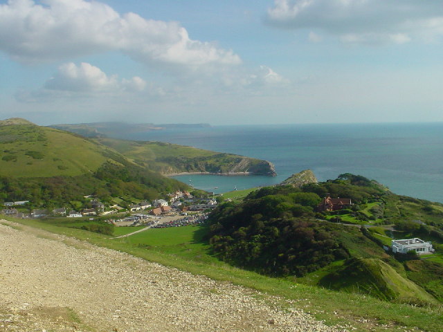
West Lulworth, Lulworth Cove. Looking down on the Cove from the clifftop path that goes right round it.
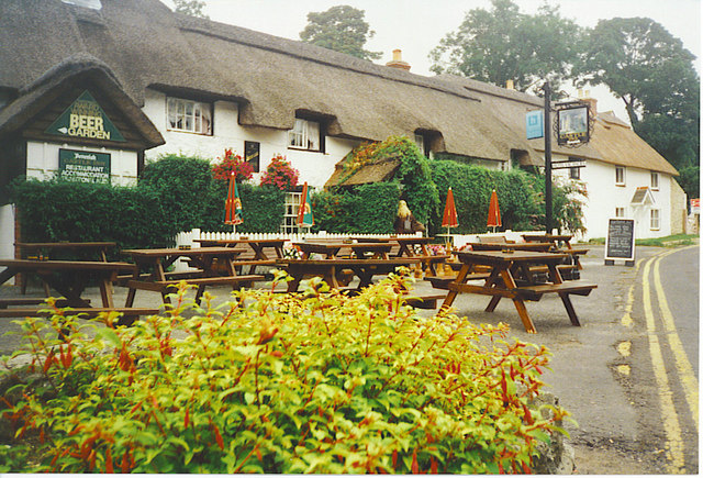
The Castle Inn, West Lulworth. A thatched pub in this attractive Dorset village. A great place to rest and relax after your exercise.
Cliff at the eastern extreme of the Scratchy Bottom embayment, Durdle Cove At the foot of the Scratchy Bottom valley there is an embayment into the chalk cliffs of Durdle Cove. This is the corner at the eastern end of the bay within a cove, exposing the chalk to the east of Scratchy Bottom. In the foreground some of the chalk of the wave-cut platform is exposed. The seams of flints in the chalk show that the strata are near-vertical. A slide-plane fault is also visible, running diagonally downwards from the top left. The chalk above the fault has moved a few metres to the left (north) - the result is that in Durdle Cove the chalk above the fault is softer than that below it and caves have formed above the fault.
Man o'War Cove. Looking down into the cove from the path on the cliffs, with Durdle Door just peeking over the neck on the right. The near-vertical strata of the headland are quite obvious in this picture. The Isle of Portland looms on the horizon above the headland.


