North Worcestershire Path OS Map
![]()
![]() This walk runs from Bewdley to Shirley, West Midlands through four beautiful country parks.
This walk runs from Bewdley to Shirley, West Midlands through four beautiful country parks.
You start in Bewdley on the River Severn and follow the river to Upper Arley, passing Trimpley Reservoir and the delightful Arley Arboretumon the way. The next section takes you through Eymore Wood and then onto Drakelow before entering Kingsford Country Park. Here you will find the magnificent Kinver Edge and 200 acres of woodland and heathland. You continue east to Cookley, where you will cross the River Stour, and then onto Hagley and the 18th century Hagley Park and gardens.
From Hagley you soon come to the next walk highlight at Clent Hills Country Park. This section offers marvellous views of the surrounding countryside. You then continue through Dales Wood to Waseley Hills Country Park and Lickey Hills Country Park with more panoramic views of Worcestershire to enjoy.
The final section runs onto Shirley passing the picturesque Bittell Reservoirs before finishing near Shirley railway station.
North Worcestershire Path Ordnance Survey Map  - view and print off detailed OS map
North Worcestershire Path Open Street Map  - view and print off detailed map
*New* - Walks and Cycle Routes Near Me Map - Waymarked Routes and Mountain Bike Trails>>
North Worcestershire Path OS Map  - Mobile GPS OS Map with Location tracking
North Worcestershire Path Open Street Map  - Mobile GPS Map with Location tracking
Pubs/Cafes
At the start/finish of the route in Bewdley there's the Mug House Inn at Bewdley Bridge. This riverside inn has a sun terrace and restaurant overlooking the River Severn. It's a fine place to enjoy a meal on a pleasant summer day. You can find the pub just north of the bridge at 12-13 Severn Side N with a postcode of DY12 2EE for your sat navs.
The visitor centre and cafe at Lickey Hills serves a great range of meals and snacks. It's a nice place to stop off and enjoy some fine views over the countryside and the city of Birmingham.
Cycle Routes and Walking Routes Nearby
Photos

Towards Berry Mound fort.

The river Severn near Victoria Bridge. Two long distance paths - the Severn Way on the Eastern bank and the North Worcestershire Path on the Western bank - flank the river Severn below Arley.

Way to Brookhouse Farm. The North Worcestershire path heads east over pasture land to Brookhouse Farm.

Footbridge over the Peterbrook, south of Haslucks Green.

Walkers in a field, near Caunsall, Worcs

School playing fields beside the Monarch's Way. The Monarch's Way and North Worcestershire Path pass by the fields of Haybridge School.

Barnt Green Sailing Club, Upper Bittell Reservoir. Upper Bittell Reservoir was constructed in the early 19th century to supply the Worcester & Birmingham Canal. Today the reservoir is home to the Barnt Green Sailing Club. General public access is restricted - a public footpath runs across the dam, from which this photo was taken. Access to the east bank is restricted as this is a SSSI.
Bench on Beacon Hill, Lickey Hills Country Park. In the middle distance is Rubery & on the horizon it's Birmingham city centre.
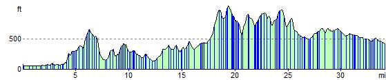
Elevation Profile