Ouse Valley Way
![]()
![]() Follow the River Great Ouse from the source at Brackley, Northamptonshire, to the mouth at The Wash at King's Lynn. You begin at Brackley and head to Buckingham, Milton Keynes, Olney, Bedford, St Neots, Huntingdon, St Ives, Ely, Downham Market before finishing at King's Lynn.
Follow the River Great Ouse from the source at Brackley, Northamptonshire, to the mouth at The Wash at King's Lynn. You begin at Brackley and head to Buckingham, Milton Keynes, Olney, Bedford, St Neots, Huntingdon, St Ives, Ely, Downham Market before finishing at King's Lynn.
Highlights on the route include the magnificent Stowe Park with its 250 acres of stunning parks and gardens.
Near Huntingdon you'll pass the National Trust's Houghton Mill. The working 18th-century watermill is set in an idyllic location on an island in the river. It's surrounded by lovely water meadows with a number of nice footpaths to follow around the site.
You'll also visit Fen Drayton Lakes and the delightful Paxton Pits nature reserve near St Neots. There's a series of lovely lakes and a heronry at this pretty site.
Ouse Valley Way Ordnance Survey Map  - view and print off detailed OS map
Ouse Valley Way Open Street Map  - view and print off detailed map
Ouse Valley Way OS Map  - Mobile GPS OS Map with Location tracking
Ouse Valley Way Open Street Map  - Mobile GPS Map with Location tracking
Pubs/Cafes
The Anchor in Little Paxton is a nice place to stop for refreshments on the route. The friendly pub has a cosy log fire for colder days and for the summer months there is a lovely outdoor dining area as well as an outside patio and play area. You can find the pub on the High Street in the village just to the west of the reserve. The postcode is PE19 6HA.
In St Neots you can visit the splendid River Mill pub. The riverside pub has dining area opening out on to the lower mill pond viewing deck. Outside there are lots of picnic tables alongside the upper mill pond and the marina. It's a lovely place to relax on a summer day. You can find it about 1 mile south of the reserve at postcode PE19 8GW.
The White Hart in Godmanchester is a historic place worthy of investigation. The 15th Century pub has a fine interior with lots of rustic charm. Outside there's an attractive garden area to relax in on warmer days. They serve delicious food and can be found on Cambridge Road at postcode PE29 2BW for your sat navs.
Cycle Routes and Walking Routes Nearby
Photos

Godmanchester Nature Reserve, Huntingdon. Cook's Stream runs alongside the Ouse Valley Way. This area has been used for sand and gravel extraction.

Lake at the Paxton Pits Nature Reserve, St Neots. Gravel pits by the River Great Ouse were dug out here between the 1940s and 1960s; the area was designated a nature reserve in the 1980s and is now an important visitor attraction as well as a haven for aquatic wildlife. The lake in this photo is called Heronry South Lake; no herons were in evidence on this occasion, but a swan can be seen in the shadow of the trees.

Pleasure boats on the River Great Ouse just below Houghton, near to Hemingford Abbots, Cambridgeshire

Weir on the river Ouse, Bourton Mill, Buckingham. This new weir was constructed as part of a programme of flood defences.

Ouse Valley Way at Houghton. The meadows along the Ouse Valley Way are still used for grazing by cows and sheep, and also used by over-wintering sea birds such as gulls. The land is often marshy and waterlogged.

Thatched cottages at Holywell

Near Thetford

Towards Earith
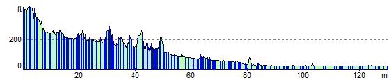
Elevation Profile