Pentre Ifan Walk
![]()
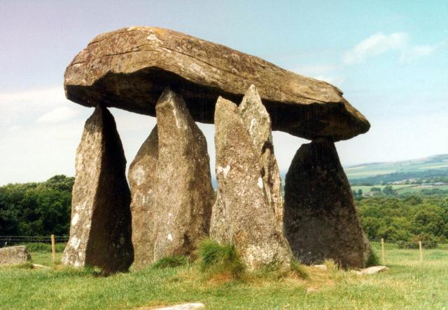
![]() Visit the largest and most well preserved neolithic dolmen in Wales on this fascinating walk in Pembrokeshire.
Visit the largest and most well preserved neolithic dolmen in Wales on this fascinating walk in Pembrokeshire.
The walk starts from the Pentre Ifan car park and follows footpaths and country lanes to the burial chamber. It's an impressive sight with 7 principal stones including a 5 metre long capstone. Built around 3,500 B.C it is classed as a Scheduled Ancient Monument.
After leaving the dolmen the walk then heads to the delightful Pentre Ifan Wood where you can enjoy several woodland trails. Here you will find ancient oak trees, a variety of plants and around 400 species of lichen. From the woods it is a short stroll back to the car park.
You can extend your walk by picking up the adjacent Ty Canol Woods Walk.
Postcode
SA42 0QR - Please note: Postcode may be approximate for some rural locationsPentre Ifan Ordnance Survey Map  - view and print off detailed OS map
Pentre Ifan Open Street Map  - view and print off detailed map
*New* - Walks and Cycle Routes Near Me Map - Waymarked Routes and Mountain Bike Trails>>
Pentre Ifan OS Map  - Mobile GPS OS Map with Location tracking
Pentre Ifan Open Street Map  - Mobile GPS Map with Location tracking
Further Information and Other Local Ideas
Head a few miles north east and you can try the Cardigan Walk. This will take you along the beautiful Teifi Estuary to Poppit Sands and the Cemaes Head Nature Reserve. It's a lovely area with fine views to Cardigan Island and lots of sea birds to look out for in the reserve. Just south of here there's also Cilgerran where you can visit the fascinating remains of the 13th century castle and enjoy a stroll along the River Teifi.
Also nearby is the delightful town of Newport. The picturesque settlement is well worth visiting with its sandy beach, excellent variety of shops and cafes, and some fine trails along the River Nevern Estuary.
To the south there's the climb to the fine viewpoints at the nearby Foel Eryr, Foel Drygarn and Foel Cwmcerwyn, the highest point in the Presili Hills. There's another ancient site near here in the shape of the Gors Fawr Stone Circle. This area has connections with the bluestones of Stonehenge.
Just to the south west there's the climb to Carn Ingli in the Preseli Hills. It's a worthy climb with a number of fascinating ancient sites dating from the Iron Age and the Bronze Age. There's also some glorious views to the coast from the summit.
In nearby Rosebush there's Rosebush Quarry to explore. The site's unusual landscape includes hidden pools, an arched underground tunnel, steep cliff faces, heath, grassland and pine trees.
To the east there's Pengelli Forest and Castell Henllys where there's some peaceful woodland trails and a fascinating Iron Age village to explore.
For more walking ideas in the area see the Pembrokeshire Coast Walks page.
Cycle Routes and Walking Routes Nearby
Photos
Pentre Ifan. This Megalithic Burial chamber dates back 5500 years. The Capstone which sits 8 feet above the ground weighs around 16 tons.
Sea view from the stone chamber. Unusually, Pentre Ifan is orientated N/S and not E/W like most burial chambers (and indeed graves generally). This intervisibility with the sea to the north, as well as its spatial relationship to other landscape features, is likely to have been significant in its siting.
Pentre Ifan in the landscape In this view from the Ty-canol lane the famous dolmen can be seen standing just inside the next gridsquare to the north.
Fferm Pentre Ifan, located near the site. This old farm is owned by Urdd Gobaith Cymru, a Welsh youth organisation, and used as an environmental/education centre which can host conferences, gatherings and events. The farm buildings which date back to the Tudor period have been beautifully restored and are used for hostel accommodation etc. The property is named after the monumental burial chamber on the hillside above.
The view to Dinas Island from the site


