South of the Landsker Trail - South Pembrokeshire Walk
![]()
![]() This circular walk explores the Pembrokeshire Coast National Park around Pembroke.
This circular walk explores the Pembrokeshire Coast National Park around Pembroke.
The walk begins at Narberth and includes a fantastic coastal section through Tenby, Saundersfoot, Manorbier and the beautiful Stackpole Estate.
The estate consists of 12 square kilometres of farmland, lakes, woodland, beaches, and cliffs including the spectacular Stackpole Quay. The video below shows the coastal section from Freshwater East to Stackpole
The route then heads inland where you can enjoy riverside sections along the River Creswell and the River Cleddau. You will also pass Carew Castle on the River Carew and the charming Landshipping Quay before returning to Narberth.
South of the Landsker Trail Ordnance Survey Map  - view and print off detailed OS map
South of the Landsker Trail Open Street Map  - view and print off detailed map
South of the Landsker Trail OS Map  - Mobile GPS OS Map with Location tracking
South of the Landsker Trail Open Street Map  - Mobile GPS Map with Location tracking
Further Information and Other Local Ideas
In Pembroke you could take some time to explore the historic Pembroke Castle. The medieval castle dates to the 12th century and is Grade I listed. You can stroll around the pleasant castle grounds and enjoy some fine views of the millpond and the River Pembroke in the attractive town.
For more walking ideas in the area see the Pembrokeshire Coast Walks page.
Cycle Routes and Walking Routes Nearby
Photos

High Street, Narberth, Pembrokeshire

Tenby Harbour

Saundersfoot

Manorbier Castle

Monkstone from Monkstone Point

Carew Castle, Mill and Millpond.

Stackpole Quay

Landshipping Quay. Looking over to Black Tar
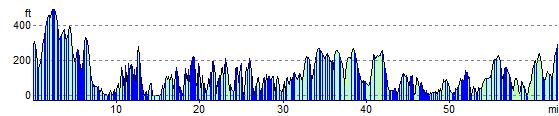
Elevation Profile