St Sunday Crag and Grisedale Tarn Walk
![]()
![]() This challenging circular walk from Patterdale climbs to this prominent fell on the north-eastern ridge of Fairfield. The circular walk climbs to Birks Fell and then onto the 841 m (2,759 ft) of St Sunday Crag. There's fabulous views of the Helvellyn range, High Street and the lake below.
This challenging circular walk from Patterdale climbs to this prominent fell on the north-eastern ridge of Fairfield. The circular walk climbs to Birks Fell and then onto the 841 m (2,759 ft) of St Sunday Crag. There's fabulous views of the Helvellyn range, High Street and the lake below.
The walk takes place on generally good footpaths on a splendid elevated ridge.
You can start your walk from the pretty village of Patterdale at the southern end of Ullswater Lake. Then follow the trail south west out of the village to Birks Fell before climbing across St Sunday Crag. You then descend to the pretty Grisedale Tarn before turning round and returning to Patterdale via Grisedale Forest and Patterdale Common.
To extend your walking in the area you could visit the lovely Aira Force Waterfall. The long distance Ullswater Way will take you on a tour of the area surrounding the lake.
Wainwright's Coast to Coast runs through the area so you could continue along the path past Grisedale Tarn towards Seat Sandal where there are more splendid views.
St Sunday Crag Ordnance Survey Map  - view and print off detailed OS map
St Sunday Crag Open Street Map  - view and print off detailed map
St Sunday Crag OS Map  - Mobile GPS OS Map with Location tracking
St Sunday Crag Open Street Map  - Mobile GPS Map with Location tracking
Pubs/Cafes
Back in Patterdale head to the White Lion Inn for some well earned refreshments. The pub has an interesting history having existed since the early 1800s. It's said that Wordsworth was in the bar as news arrived that Nelson had died at Trafalgar in 1805. The interior is full of old world charm while outside there's a nice beer garden just across the road. It's a lovely place to relax and soak in the fine views if the weather is good. You can find the pub in the village at postcode CA11 0NW for your sat navs.
Dog Walking
It's a great walk for fit dogs and the White Lion Inn mentioned above is also dog friendly.
Further Information and Other Local Ideas
The climb to the lovely Angle Tarn also starts from Patterdale. It's an easier walk which visits the Angletarn Pikes with more fine views.
Around Ullswater Lake there's lots more good walking opportunities. You could try the Glenridding to Aira Force Walk and visit a wonderful waterfall and woodland area. The Howtown to Glenridding Walk can also be picked up in nearby Glenridding. The easy trail follows the lakeshore to Howtown Pier where the Ullswater Steamer boats dock.
For more walking ideas in the area see the Lake District Walks page.
Cycle Routes and Walking Routes Nearby
Photos

St Sunday Crag. The descent to Deepdale Hause on the ridge continuing to Fairfield. To the right is Grisedale Tarn with Seat Sandal beyond.

Summit Cairn, St. Sunday Crag The magnificent St. Sunday Crag apparently named after St. Mungo a local Celtic Saint. Helvellyn ridge on the skyline.

Path on Birks. Three walkers and their dog on the path across Birks, east of the crag.

Summit Cairn, Birks. On the top of grassy Birks looking up at St. Sunday Crag and over to the Helvellyn range.

The gentle descent to Deepdale Hause

Deepdale Hause. The col between St Sunday Crag and Fairfield, looking towards the latter. The ridge initially climbs to Cofa Pike with the summit of Fairfield set back on the plateau beyond.
.jpg)
Grisedale Tarn

Grisedale
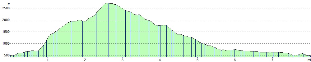
Elevation Profile