Ullswater Way
![]()
![]() Explore the area around Ullswater Lake on this waymarked circular walk in the Lake District National Park. The route includes a mixture of easy lakeside sections and some more challenging climbs above the lake into the surrounding hills. There's fabulous views of the Helvellyn range on the section from Howtown to Glenridding. This part of the route on the southern side of the lake is considered to be the finest lakeside walk in the Lake District.
Explore the area around Ullswater Lake on this waymarked circular walk in the Lake District National Park. The route includes a mixture of easy lakeside sections and some more challenging climbs above the lake into the surrounding hills. There's fabulous views of the Helvellyn range on the section from Howtown to Glenridding. This part of the route on the southern side of the lake is considered to be the finest lakeside walk in the Lake District.
The first section takes you from Pooley Bridge to Howtown heading south west along the lake towards Hallin Fell and Barton Park. You continue with a woodland section through Hallinhag Wood before passing Scalehow Force Waterfall and Birk Fell. The route continues past Patterdale Common and Place Fell to the small village of Patterdale where you can stop for refreshments. This is about the halfway point on the walk.
The second section takes you from Patterdale to Glenridding and then along the lake towards Glencoyne Wood and Glencoyne Park. Here you climb towards the wonderful Aira Force.
The next section is quite challenging as you climb past Gowbarrow Fell to the woodland in Swinburn's Park. The walk then descends back to Pooley Bridge passing Wreay and Dunmallard Hill on the way.
It's a splendid walk with great views over the lake and the surrounding mountains from the high points.
Please click here for more information
Ullswater Way Ordnance Survey Map  - view and print off detailed OS map
Ullswater Way Open Street Map  - view and print off detailed map
*New* - Walks and Cycle Routes Near Me Map - Waymarked Routes and Mountain Bike Trails>>
Ullswater Way OS Map  - Mobile GPS OS Map with Location tracking
Ullswater Way Open Street Map  - Mobile GPS Map with Location tracking
Pubs/Cafes
We recommend stopping in Howtown at the Howtown Hotel for some refreshments on your walk. There are some delightful tea rooms situated adjacent to the Hotel, offering a separate facility for walkers and visitors to enjoy a range of delicious home-made scones, cakes, light lunches and coffees throughout the day. There's also a pretty garden area to sit out in on warmer days. You can find the hotel next to the pier with a postcode of CA10 2ND for your sat navs.
In Patterdale there's the noteworthy White Lion Inn. The pub has an interesting history having existed since the early 1800s. It's said that Wordsworth was in the bar as news arrived that Nelson had died at Trafalgar in 1805. The interior is full of old world charm while outside there's a nice beer garden just across the road. It's a lovely place to relax and soak in the fine views if the weather is good. You can find the pub in the village at postcode CA11 0NW for your sat navs. It's also dog friendly.
Further Information and Other Local Ideas
In Patterdale a couple of popular climbs can be started. The fairly challenging climg to St Sunday Crag and the easier one to the lovely Angle Tarn both start from the village.
The climb to Bonscale Pike and Arthur's Pike starts at Howtown. They are both fine Ullswater viewpoints with the photogenic Bonscale Tower a highlight on the walk. You can take a small detour from the route at Howton to climb to the fells as an optional walk extension.
For more walking ideas in the area see the Lake District Walks page.
Cycle Routes and Walking Routes Nearby
Photos

Southern Ullswater. From south of Glenridding, this is the bottom end of Ullswater looking towards Patterdale.

Ullswater from the lakeshore path near Mossdale Bay

Looking towards the Helvellyn range from the shoreline below the A592. Place Fell rises to the left.

Hallinhag Wood, Ullswater. View through the trees across Sandwick Bay.

Howtown Pier on Ullswater. This pier is situated not too far from a good pub! As far as the square goes, it's in the top left hand corner.

Autumn colours, Ullswater

Long Crag

Silver Bay. Looking west with Hart Side (centre) and Glencoyne (left) in the background
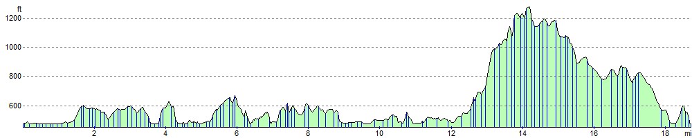
Elevation Profile