Seat Sandal Walk
![]()
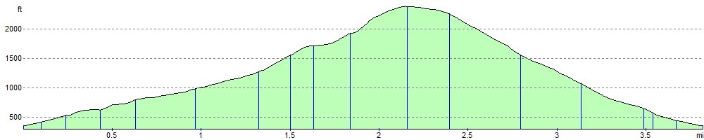
![]() This circular walk climbs to Seat Sandal fell near Grasmere in the Lake District National Park. You can start the walk from the layby parking just off the A591 at Mill Bridge. Head north from layby, crossing Tongue Gill before picking up the footpaths heading north east. The first section follows Wainwright's Coast to Coast along Tongue Gill to the Farfield Iron Mine. The route continues al the C2C to Grisedale Hause where you turn south west towards the Seat Sandal summit. From the 736 m (2,415 ft) summit you can see the Helvellyn and Fairfield ranges, the Solway Firth, the Scottish mountains and Morecambe Bay to the south. After taking in the views you descend back to the start point on the western side of Great Tongue. You could also descend on a section of the C2C via Little Tongue Gill.
This circular walk climbs to Seat Sandal fell near Grasmere in the Lake District National Park. You can start the walk from the layby parking just off the A591 at Mill Bridge. Head north from layby, crossing Tongue Gill before picking up the footpaths heading north east. The first section follows Wainwright's Coast to Coast along Tongue Gill to the Farfield Iron Mine. The route continues al the C2C to Grisedale Hause where you turn south west towards the Seat Sandal summit. From the 736 m (2,415 ft) summit you can see the Helvellyn and Fairfield ranges, the Solway Firth, the Scottish mountains and Morecambe Bay to the south. After taking in the views you descend back to the start point on the western side of Great Tongue. You could also descend on a section of the C2C via Little Tongue Gill.
To extend your walk you can continue along the C2C to Grisedale Tarn which is just to the north of Seat Sandal. The path will eventually lead you to St Sunday Crag where there's great views over Ullswater.
The fell is also very close to the route for the Fairfield Horseshoe which is another popular climb in the area.
Seat Sandal Ordnance Survey Map  - view and print off detailed OS map
Seat Sandal Open Street Map  - view and print off detailed map
Seat Sandal OS Map  - Mobile GPS OS Map with Location tracking
Seat Sandal Open Street Map  - Mobile GPS Map with Location tracking
Further Information and Other Local Ideas
Just to the north east of the summit you can visit the lovely Grisedale Tarn if you have time.
For more walking ideas in the area see the Lake District Walks
Cycle Routes and Walking Routes Nearby
Photos

Grisedale from Seat Sandal. Looking down Grisedale to Ullswater in the far distance from Seat Sandal summit, St Sunday Crag is the fell on the right.

On Seat Sandal

Ascending

View towards Seat Sandal. Photo taken from the broad grassy ridge to the back of Pavey Ark. By using the zoom, some foreground rocks add some interest to the foreground.

Tongue Gill

Hause Riggs. Crags under hill top seen on the ascent via Tongue Gill

Field Barn by Tongue Gill footpath

Looking up Tongue Gill
Elevation Profile