Table Mountain Walk
![]()
![]() Enjoy wonderful views over the Brecon Beacons on this moderate climb to the 451m peak of Table Mountain (Crug Hywel). The walk starts from the pretty town of Crickhowell with its ruined Norman castle and 18th century 13-arched bridge across the river Usk. You then follow the Table Mountain footpath which starts at the northern end of the town. It passes through fields and woodland to the unusual flat top of the mountain. At the top you will find an Iron Age Hill Fort and wonderful views in all directions.
Enjoy wonderful views over the Brecon Beacons on this moderate climb to the 451m peak of Table Mountain (Crug Hywel). The walk starts from the pretty town of Crickhowell with its ruined Norman castle and 18th century 13-arched bridge across the river Usk. You then follow the Table Mountain footpath which starts at the northern end of the town. It passes through fields and woodland to the unusual flat top of the mountain. At the top you will find an Iron Age Hill Fort and wonderful views in all directions.
If you would like to extend the walk then you could continue north along the Cambrian Way to the summit of Pen Cerrig Calch, a subsidiary summit of Waun Fach, standing at a height of 701 metres.
You could also pick up the Usk Valley Walk which runs past Crickhowell. The long distance Brecon Beacons Way also passes Table Mountain so you can easily pick this up too.
Table Mountain Ordnance Survey Map  - view and print off detailed OS map
Table Mountain Open Street Map  - view and print off detailed map
Table Mountain OS Map  - Mobile GPS OS Map with Location tracking
Table Mountain Open Street Map  - Mobile GPS Map with Location tracking
Further Information and Other Local Ideas
The epic Cambrian Way passes over the mountain. The long distance waymarked route starts from the city of Cardiff and runs for nearly 300 miles through the Brecon Beacons, the Cambrian Mountains and Snowdonia before finishing on the North Wales coast at Conwy.
Cycle Routes and Walking Routes Nearby
Photos

Pen Cerrig-calch and Table Mountain. The 701m high Pen Cerrig-calch and the distinctive Table Mountain viewed from the Monmouthshire and Brecon near Llangattock.

In the foreground are a few bluebells and emerging bracket beside the canal towpath.

Detail of the bench cut into the west side of Crug Hywel to make the site more defensible - it must have been hard work, hacking through the rock to create it!

Dol-y-gaer below Crug Hywel An old image which shows how the newer farmhouse, left, facing south, replaced an older dwelling to the side, facing west, with chimney and beasthouse/hayloft to the right. The old place, long dilapidated and used for storage, had two small dark downstairs rooms with fireplace and oven and a stone stairway leading to a single upstairs room which had its own access at a higher level. The old stone roof has been patched with corrugated metal sheeting. The name, Dol-y-gaer, means meadow (at) the camp, referring to the fortified hill above.

Crags on Crug Hywel / Table Mountain. The steep side of the Iron Age hill fort. The town in the valley is Crickhowell.

Table mountain is rather grandiosely named, being just an outcrop on the south side of Pen Cerrig Calch. It was used as a hill fort during the Iron Age - it must have been the obvious choice for that purpose at the time due to its large level surface surrounded by crags on almost all sides! Crickhowell, the town below, was named after the fort. The area surrounding Table Mountain to W, S and E is enclosed farmland.
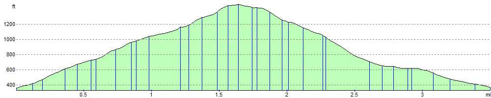
Elevation Profile