Tarka Trail OS Map and GPX Download
![]()
![]() This wonderful walk through Devon follows the path taken by Tarka the Otter in the book of that name. It is a circular walk starting and finishing in Barnstaple on the River Taw. After following the river for a short section you will head through Landkey Newton and East Buckland to the Exmoor National Park. The route then reaches Lynmouth where a splendid coastal section that takes you through Ilfracombe, Woolacombe and Croyde. The final section follows the estuary of the River Taw through Braunton and then back into Barnstaple. This part of the route passes the beautiful Braunton Burrows Nature Reserve.
This wonderful walk through Devon follows the path taken by Tarka the Otter in the book of that name. It is a circular walk starting and finishing in Barnstaple on the River Taw. After following the river for a short section you will head through Landkey Newton and East Buckland to the Exmoor National Park. The route then reaches Lynmouth where a splendid coastal section that takes you through Ilfracombe, Woolacombe and Croyde. The final section follows the estuary of the River Taw through Braunton and then back into Barnstaple. This part of the route passes the beautiful Braunton Burrows Nature Reserve.
The reserve covers nearly 900 hectares making it the second largest dune system in England.
Please click here for more information.
Tarka Trail Ordnance Survey Map  - view and print off detailed OS map
Tarka Trail Open Street Map  - view and print off detailed map
*New* - Walks and Cycle Routes Near Me Map - Waymarked Routes and Mountain Bike Trails>>
Tarka Trail OS Map  - Mobile GPS OS Map with Location tracking
Tarka Trail Open Street Map  - Mobile GPS Map with Location tracking
Pubs/Cafes
Instow is a pleasant place to stop off for some refreshments. The Boathouse is in an excellent spot overlooking the beach and the river here. They serve great seafood which you can enjoy from the splendid ‘Top Deck’ terrace. You can find them on Marine Parade at postcode EX39 4JJ.
The village is worthy of exploration with features including a lovely riverside beach and a church dating back to the 13th century
Further Information and Other Local Ideas
Just to the south of Barnstaple the trail passes very close to Codden Hill at Bishop's Tawton. You could take a small detour from the route to climb to the summit where you'll find the monument to Caroline Thorpe, wife of local MP Jeremy Thorpe who became embroiled in the Thorpe scandal of the 1970s. There's also some splendid views over the area and waterside trails along the pretty Venn Stream to enjoy in this area.
Cycle Routes and Walking Routes Nearby
Photos

The Tarka Trail to the west of Barnstaple, Devon. This section of the Tarka Trail runs along the bed of the former Barnstaple to Torrington Line, and also carries the South West Coast Path.

The Tarka Trail, passing through woodland near the clay works on Clay Moor near Peters Marland, Devon.

The trail, combining footpath and cycleway (National Cycle Route 3), follows the former track of the North Devon and Cornwall Junction Light Railway across Bury Moors.

Tarka Trail Exmoor National Park

Sculpture by Tarka Trail. In the background is Instow. The Tarka Trail uses the old railway line around the Taw & Torridge estuaries.

The long-distance footpath just after turning off the lane south of Iddesleigh alongside a stream near Devon Lodge.

The trail, NCN27, and the South West Coast Path follow Ashford Footpath 13 along the line of the old Barnstaple-Braunton railway line, running beside the Taw estuary, and here passing a sewage works hidden on the right.

The path heading north on the east side of the East Oakmount or East Okement valley.
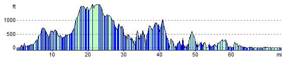
Elevation Profile