Tetbury Walks - Near and Around
![]()
![]() The classic Cotswolds town of Tetbury has a number of lovely waymarked trails running past it. You can pick these up to explore the attractive countryside surrounding the town and to visit some of the local attractions. This walk makes use of the Monarch's Way and the Macmillan Way to visit the wonderful Westonbirt Arboretum, the 16th century Chavenage House and the nearby village of Avening. It's about a 10 mile walk in total with the option of getting the bus back from Avening to Tetbury.
The classic Cotswolds town of Tetbury has a number of lovely waymarked trails running past it. You can pick these up to explore the attractive countryside surrounding the town and to visit some of the local attractions. This walk makes use of the Monarch's Way and the Macmillan Way to visit the wonderful Westonbirt Arboretum, the 16th century Chavenage House and the nearby village of Avening. It's about a 10 mile walk in total with the option of getting the bus back from Avening to Tetbury.
The walk starts at the southern section of the town where you can pick up the Monarch's Way and head south along Longfurlong Lane towards Westonbirt Arboretum. The arboretum is one of the highlights of the Cotswolds with 600 acres and 15,000 tree specimens to see. It is simply stunning the autumn months.
After exploring the arboretum you then pick up the Macmillan Way and head north towards Beverston. The village is home to a Norman Church and Beverstone Castle which dates from the 12th century.
The path continues north to Chavenage House. The Elizabethan manor house was built in 1576 and is constructed of Cotswold stone. On certain days in the summer months you can tour the house and gardens. Click here for more details.
The final section of the walk takes you through the countryside to Avening. Here you can enjoy refreshments at one of the two pubs before catching the bus back to Tetbury.
Tetbury Ordnance Survey Map  - view and print off detailed OS map
Tetbury Open Street Map  - view and print off detailed map
*New* - Walks and Cycle Routes Near Me Map - Waymarked Routes and Mountain Bike Trails>>
Tetbury OS Map  - Mobile GPS OS Map with Location tracking
Tetbury Open Street Map  - Mobile GPS Map with Location tracking
Pubs/Cafes
There's some classic old town pubs for some post walk refreshment. The Royal Oak dates from the 17th century and includes a charming interior with upcycled furnishings, cosy booths, a beautiful Art Deco piano and a vintage jukebox. Outside there's ‘The Tavern on the Green’ for a heated, covered place to enjoy a drink. The garden is very large and an ideal place to relax in the summer months. You can find them on the Cirencester Road with a postcode of GL8 8EY for your sat navs.
Dog Walking
The country and woodland trails make for a fine dog walk. The Royal Oak mentioned above is also dog friendly.
Further Information and Other Local Ideas
In the town you can pick up the circular Tetbury Railway Walk which starts from the Station Yard car park. It will take you along the course of the old railway which ran to Kemble before being closed.
Head a few miles south east and you will soon come to the noteworthy town of Malmesbury. There's much to enjoy here with the 12th century Malmesbury Abbey, the beautiful Abbey House Gardens, river walks and the oldest hotel in England.
For more walking ideas in the area see the Cotswolds Walks and the Gloucestershire Walks pages.
Cycle Routes and Walking Routes Nearby
Photos
Chavenage House has been built over the centuries ranging from the late 16th century through to the turn of the 20th century. The house has been used in many TV productions and is also a location for weddings. The house is open to the public on selective days. The principal guide is the owner whose anecdotal tour is memorable and entertaining.
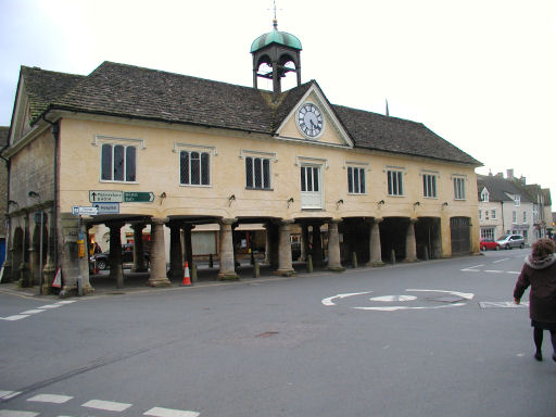
The Market House. The Market House in Tetbury stands in the Market Place. The building dates from 1655 and the pillars, providing seven bays by two, offered a sheltered location for a market. The building was enlarged in 1740 and further remodelled in 1816-17 when high gables were replaced with the present roof.
Bath Bridge Arches. Fine cotswold stone bridge was built in 1777 to carry the A433 from Tetbury to Bath this photo was taken from Black Horse Hill West Street
The Market House in Tetbury stands in the Market Place. The building dates from 1655 and the pillars, providing seven bays by two, offered a sheltered location for a market. The building was enlarged in 1740 and further remodelled in 1816-17 when high gables were replaced with the present roof.


