Thames Down Link OS Map
![]()
![]() This walk links the Thames Path and North Downs Way National Trails. It runs for about 15 miles through countryside, woodland and common land.
This walk links the Thames Path and North Downs Way National Trails. It runs for about 15 miles through countryside, woodland and common land.
The walk starts in Kingston upon Thames and heads south along the Hogsmill River to Epsom Common, Ashtead Common National Nature Reserve, Horton Country Park and Mickelham Downs. The route finishes at Westumble near the pretty Box Hill Country Park in Surrey.
Parts of the route are also suitable for cyclists.
Thames Down Link Ordnance Survey Map  - view and print off detailed OS map
Thames Down Link Open Street Map  - view and print off detailed map
*New* - Walks and Cycle Routes Near Me Map - Waymarked Routes and Mountain Bike Trails>>
Thames Down Link OS Map  - Mobile GPS OS Map with Location tracking
Thames Down Link Open Street Map  - Mobile GPS Map with Location tracking
Pubs/Cafes
At Epsom Common you'll pass near to the delightful Cricketers Inn. It's in a lovely spot with views of the picturesque cricket green and duck pond. There's an attractive interior and an outdoor area for warmer days. You can find the pub at 1 Stamford Green Road with a postcode of KT18 7SR for your sat navs.
Further Information and Other Local Ideas
The route is coincident with the London Loop. You could pick up this long waymarked trail to further explore the area around the link. You'll also pass the Chessington Countryside Walk which takes you past the famous local theme park and zoo.
For more walking ideas in the area see the Greater London Walks and the Surrey Walks pages.
Cycle Routes and Walking Routes Nearby
Photos

Ashtead Common, Thames Downs Link path at junction with Epsom common

Castle Hill Nature Reserve, Chessington

View of the trail through Epsom Common

West Park Water Tower from Horton Country Park. By Epsom Polo Club

Kingston, Clattern Bridge, Hogsmill river

Stane Street, Tyrrell's Wood
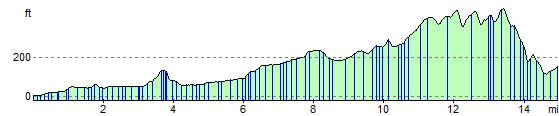
Elevation Profile