Three Peaks Walk
![]()
![]() This is a fairly hilly circular route taking you through some of the most peaceful and attractive countryside in Somerset.
This is a fairly hilly circular route taking you through some of the most peaceful and attractive countryside in Somerset.
The walk starts and finishes in the pretty village of Chew Magna and follows the path to Pensford and then back via Clutton.
You will climb Knowle Hill, Maes Knoll, and Blackberry Hill (three peaks) while enjoying excellent views of the Mendip Hills, Dundry Hill and the surrounding Chew Valley countryside. The route also passes very close to the popular Chew Valley Lake where you will find a lovely nature trail on the eastern shores. The trail is well surfaced and offers great views across the lake towards Denny Island, a nesting site for Great Crested Grebe, Tufted Duck and Canada Geese. Near here you will also pass the pretty village of Pensford and the impressive Grade II listed Pensford Viaduct.
Three Peaks Walk Ordnance Survey Map  - view and print off detailed OS map
Three Peaks Walk Open Street Map  - view and print off detailed map
Three Peaks Walk OS Map  - Mobile GPS OS Map with Location tracking
Three Peaks Walk Open Street Map  - Mobile GPS Map with Location tracking
Cycle Routes and Walking Routes Nearby
Photos

East from Maes Knoll. The eastern edge of the hill fort is in the foreground. New Barn Farm is to the right just above the hedgerow. Then houses at the top of Hursley Hill.

Knowle Hill. A view towards the summit of Knowle hill through the bracken. The area is open access land and a maze of rough pathways wind their way through the bracken to the summit.

Mobile phone mast on Blackberry Hill. The hill is located between the villages of Clutton and Farmborough. Just south of here you could take a small detour from the route to visit the peaceful woodland trails at Greyfield Woods and the pretty village of Timsbury.

Byway near Barrow Vale

Three Peaks Walk approaching Hunstrete

Three Peaks Walk at Whidcombe Brake

Pensford High Street. St Thomas A Beckett Church and Pensford Viaduct in distance.

Chew Magna Ford
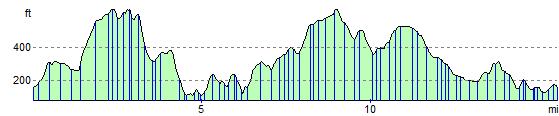
Elevation Profile