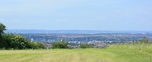
Maes Knoll
![]()
![]() This circular walk climbs to a fine viewpoint and ancient Iron Age Hill fort in Somerset.
This circular walk climbs to a fine viewpoint and ancient Iron Age Hill fort in Somerset.
The walk starts in the village of Pensford where you can pick up the Three Peaks Walk and follow the waymarked trail north west past the impressive Pensford Viaduct. The trail then heads north through the countryside to Norton Malreward before climbing up to Maes Knoll. The hill stands at a height of 197 metres and includes a 20 acre hillfort. From the summit there are great views to east to Bath and the Cotswold Hills, north to Bristol, south over Stanton Drew stone circles to Chew Valley Lake and the Mendip Hills.
After taking in the views you head north and then west towards East Dundry where you have the option of climbing Dundry Hill. This route heads south to North Wick and Chew Magna where you cross the River Chew. Here you pick up the Two Rivers Way and follow the path east to Stanton Drew, passing the stone circles on the way. Shortly after you pick up a riverside path taking you back into Pensford.
Maes Knoll Ordnance Survey Map  - view and print off detailed OS map
Maes Knoll Open Street Map  - view and print off detailed map
Maes Knoll OS Map  - Mobile GPS OS Map with Location tracking
Maes Knoll Open Street Map  - Mobile GPS Map with Location tracking
Pubs/Cafes
Back in Pensford you could head to The Rising Sun for some post walk refreshment. The pub has a particularly lovely garden area with views of the river and the viaduct. You can find them on Church Street with a postcode of BS39 4AQ for your sat navs.
Dog Walking
The country trails and hill climbs are great for fit dogs. The Rising Sun mentioned above is also dog friendly.
Further Information and Other Local Ideas
For more walking ideas in the area see the Mendip Hills Walks page.
Cycle Routes and Walking Routes Nearby
Photos
Pensford railway viaduct. This well preserved, elegant, railway viaduct at Pensford reminds us that public transport via railways was better provided at the local level than today. The cast iron agricultural item in the foreground may be a hand pump over a well.
South of west on the Knoll. Farmland stretches across North Somerset toward Chew Magna, which is well hidden. We are on the approach for aircraft landing at Bristol International Airport, unusual not to see one on the run-in.
Maes Knoll is an Iron Age hillfort, triangular or rather more Africa-shaped when viewed from the air. It occupies the Oolite ridge that commands the hills south of Bristol. This ridge, which stretches from Dundry Hill to Maes Knoll, steeply descends down to the north and the Avon Valley, creating a fine view over the Lower Avon Valley from Clifton Gorge to the Cotswold escarpment. The two white towers in the distance are about all that can be seen in this image of the Severn Suspension Bridge between Aust and Beachley.
South on the Knoll. Viewed from within the "Fort." Looking toward Stanton Drew. Look on the horizon to the right of the tree, if your eyes are sharp enough you will be able to see the Mendip TV transmitter on Pen Hill
Due south on the Knoll. Part of the western slope can be seen. Beyond the lane is a large hedgerow, beyond the hedgerow is a field with small lumps in that look like cattle. This is the neolithic stone circle at Stanton Drew. The village itself is to the right if you look very closely you may see the parish church.
East from the edge of the Knoll. On the southern slopes, the valley below is north of Pensford. Newton St.Loe and Bath are hidden beyond the next hill. Beckford's Tower on Lansdown is to the far left on the skyline
Remains of Bye Mill west of Pensford. Bye Mill was a large mill used for hammering and manufacturing tools. It later became a paper mill. The type of paper it made was used in those days for paper bags in grocer shops to wrap goods. The material used is reputed to be re-cycled paper and rags from Bristol.


