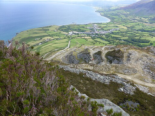
Trefor Quarry Walk

 This walk visits the Yr Eifl Quarry in the coastal village of Trefor on the Llyn Peninsula, Gwynedd.
The walk starts in the village and heads west to pick up the track up to the quarry. Here you can follow trails around the unusual landscape while enjoying some splendid views to the coast and the village from the elevated location. It's a photogenic place with the old abandoned buildings and the steep cliff faces.
You can extend your walk by continuing south to climb to Yr Eifl mountain and Tre'r Ceiri where you will find Britain's best preserved Iron Age hill fort. You could also pick up the Llyn Coastal Path and visit the nearby Trefor Sea Stacks.
Trefor Quarry Ordnance Survey Map  - view and print off detailed OS map
Trefor Quarry Open Street Map  - view and print off detailed map
Trefor Quarry OS Map  - Mobile GPS OS Map with Location tracking
Trefor Quarry Open Street Map  - Mobile GPS Map with Location tracking
Walks near Trefor
- Yr Eifl - Climb the Yr Eifl mountain group on this challenging circular walk on the Llyn Peninsula
- Llyn Coastal Path - Follow the Llyn Peninsula from Caernarfon to Porthmadog on this stunning coastal walk
- Trer Ceiri - This walk climbs to the Iron Age Hillfort of Tre'r Ceiri on the Llyn Peninsula in Wales
- Garn Fadryn - This walk climbs to the remote Iron Age Hillfort at Garn Fadryn in the Llyn Peninsula .
- Garn Boduan - This walk takes you up to the Iron Age Hill fort of Garn Boduan on the Llyn Peninsula near Nefyn
- Nant Gwrtheyrn - This Welsh Language Heritage Centre is located near the village of Llithfaen on the wonderful Llyn Peninsula.
Pubs/Cafes
In the village you can enjoy some post walk refreshments at Tafarn Y Tŵr. The friendly pub serves a good pint and as a nice garden area to sit out in. You can find them at Eifl Rd, LL54 5LH.


