Cadair Idris Walk
![]()
![]() The epic circular walk to the 893 m (2,930 ft) summit of Cadair Idris is one of the most popular climbs in the Snowdonia National Park. This route follows the Minffordd Path and begins near the car park at Minffordd and the glacial Tal-y-llyn Lake. The area is part of a National Nature Reserve which includes woodland, streams, waterfalls and some wonderful geological formations such as the cliffs of Cwm Cau.
The epic circular walk to the 893 m (2,930 ft) summit of Cadair Idris is one of the most popular climbs in the Snowdonia National Park. This route follows the Minffordd Path and begins near the car park at Minffordd and the glacial Tal-y-llyn Lake. The area is part of a National Nature Reserve which includes woodland, streams, waterfalls and some wonderful geological formations such as the cliffs of Cwm Cau.
The walk starts from the Dol Idris Car Park at the junction of the A487 & B4405 (postcode: LL36 9AJ). There's plenty of parking here with toilets facilities also. From here you can easily pick up the Minffordd Path which will guide you up to the summit.
You begin the walk with a lovely woodland section with streams and waterfalls before ascending towards the stunning Llyn Cau. This beautiful lake is surrounded by huge cliffs and is a breathtaking sight, particularly when viewed from above. You continue around the lake towards Penygadair - the highest point on the mountain. From here there are magnificent views of the Barmouth estuary, the Cambrian Mountains, the Brecon Beacons, the Rhinogs and the rest of Snowdonia National Park. You continue east to Mynydd Moel and descend towards Moelfryn, crossing the Nant Cadair before returning to the car park through the woodland.
After your hike you can enjoy refreshments at the splendid Ty Te Cadair Tea Room where there's outdoor seating with great views.
To further explore the mountain head to Cregennan Lakes on the northern slopes. There's a nice footpath round the lovely lakes with the the Cadair Idris Visitor Centre also located near by. The centre includes a wealth of information and an exhibition detailing the wildlife and geology of this fascinating area.
Postcode
LL36 9AJ - Please note: Postcode may be approximate for some rural locationsCadair Idris Ordnance Survey Map  - view and print off detailed OS map
Cadair Idris Open Street Map  - view and print off detailed map
Cadair Idris OS Map  - Mobile GPS OS Map with Location tracking
Cadair Idris Open Street Map  - Mobile GPS Map with Location tracking
Pubs/Cafes
The Minffordd Hotel is located at the start of the route and a nice place for some post walk refreshments. The historic pub is hundreds of years old and includes low beamed ceilings and a log fire for those cold winter days. It's a friendly place with a good menu and they also provide good quality accommodation if you need to stay over.
There's also the Tŷ Te Cadair Tea Room near the start of the path. It's in a lovely spot right next to a waterfall and has indoor and outdoor seating.
Further Information and Other Local Ideas
To the east there's the expansive Dyfi Forest to explore. The forest has miles of good mountain biking and walking trails to try.
A few miles to the south west there's a real gem at Dolgoch Falls. You can follow a wooden walkway to the woodland ravine where you'll find the magical falls. The splendid Talyllyn Railway can also be picked up in this area. The heritage railway will take you to the coast at Tywyn where there is a lovely long beach, sand dunes, a large lake and views of the River Dysynni.
To the south there's the worthy village of Abergynolwyn to visit. The historic settlement is located on the heritage Talyllyn Railway and includes pleasant trails along the Nant Gwernol waterfalls to the old Bryn Eglwys Quarry. Near here you can also explore the mediaeval remains of Castell Y Bere.
For more walking ideas in the area see the Snowdonia Walks page.
Cycle Routes and Walking Routes Nearby
Photos

The Minffordd path, here climbing steeply, above the Nant Cadair, on the first part of its journey

The Minffordd Path east of Craig Cau. After a steady climb from Cwm Cau to reach the ridge, a further steady climb up the ridge will eventually bring you to this point, where the path wanders along an almost level course before reaching the foot of the stiff climb up and over Craig Cau; the mighty crag itself can be seen ahead.

Nant Cadair Falls alongside the Minffordd Path. The path is a beautiful approach to Cadair Idris. The first part from the car park at Minffordd is quite steep as it climbs alongside the Nant Cadair Falls before the path becomes a little easier on the way to Llyn Cau.

Looking north east from the Minffordd path. Taken from where the path climbs its steepest section on the ridge which bounds the south side of Cwm Cau. In the middle distance is the south ridge of Mynydd Moel, with Waun Oer in the far distance.

Llyn Cau

Cwm Cau. Taken from the Minffordd path as it heads for the upper cwm. Craig Cau is the peak on the left, the summit of Cadair Idris to the right.

View towards Mynydd Dol-ffanog. Looking past the wooded crags of Craig Cwmrhwyddfor from the Minffordd path.

View towards Pen y Gadair. Looking across Cwm Cau from the Minffordd path.
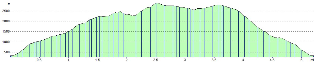
Elevation Profile