Chrome Hill Dragon's Back Walk
![]()
![]() This circular walk climbs the beautiful Chrome Hill in the Upper Dove valley area of the Peak District. You will visit the Chrome and Parkhouse Hills SSSI, an area with fascinating geology and limestone flora. It is also known as the Dragon's Back ridge.
This circular walk climbs the beautiful Chrome Hill in the Upper Dove valley area of the Peak District. You will visit the Chrome and Parkhouse Hills SSSI, an area with fascinating geology and limestone flora. It is also known as the Dragon's Back ridge.
The walk starts from the little village of Earl Sterndale near Buxton.
The village is a popular start point for walks because of its proximity to Dovedale, High Wheeldon, Parkhouse Hill and Chrome Hill. There is also an old pub called the Quiet Woman where you can find refreshments at the end of your walk.
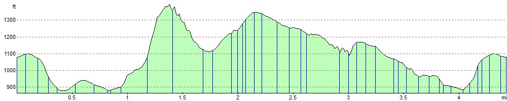
From Earl Sterndale you follow footpaths to Parkhouse Hill. The distinctive hill sits just to the north of the River Dove and stands at a height of 360 m (1,180 ft). You continue the ascent to the higher Chrome Hill which stands at 425 m (1394 ft). There are wonderful views over the Dove Valley towards the surrounding Peak District Hills.
The walk then descends to Tor Rock and then through Dowel Dale on a nice country lane. You then pick up another footpath to Glutton Grange and Glutton Dale, before returning to Earl Sterndale.
If you would like to continue your walking in the area then you could head to Buxton and climb to Solomon's Temple in Buxton Country Park. The Dane Valley Way long distance walk also runs through Buxton.
Postcode
SK17 0BU - Please note: Postcode may be approximate for some rural locationsChrome Hill Ordnance Survey Map  - view and print off detailed OS map
Chrome Hill Open Street Map  - view and print off detailed map
*New* - Walks and Cycle Routes Near Me Map - Waymarked Routes and Mountain Bike Trails>>
Chrome Hill OS Map  - Mobile GPS OS Map with Location tracking
Chrome Hill Open Street Map  - Mobile GPS Map with Location tracking
Pubs/Cafes
In Earl Sterndale you could head to the Quiet Woman for some post walk refreshments. It's in a picturesque location opposite the church and village green. There's a fine interior with a low-beamed room with a real fire to warm yourself next to in the winter months. Outside there's a pub garden to relax in on warmer days. You can find the pub at a postcode of SK17 0BU. The pub has an interesting history as it is reputed to be over 400 years old and was in the occupation of the Heathcote family for over 300 years. The name is unusual with only two others in the country.
Not far from the hill and well worth a visit is the Knights' Table at the Travellers Rest. Another historical pub there is a medieval Knights' theme running throughout (relating to the legend of Sir Gawain and the green knight). Inside you'll find open fires, exposed beams and stone paved floors complimented with new medieval style furniture and candles. Outside there's a patio with magnificent Peak District Views from the elevated position of the pub. You can find the pub a few miles west of the hill at Quarnford with a postcode of SK17 0SN for your sat navs.

Pictured above, the Quiet Woman in Earl Sterndale.
Further Information and Other Local Ideas
For an alternative route to the hill see the Hollinsclough Walk page. This circular walk starts from Hollinsclough village and takes in Hollins Hill which lies just west of Chrome Hill.
A few miles west of the hill you'll find one of the highlights of the area at Three Shires Head. It's a very picturesque spot where the counties of Cheshire, Derbyshire and Staffordshire meet. There's a fine Grade II-listed packhorse bridge over the River Dane and lots of pretty waterfalls to see here.
There's also the popular climb to High Wheeldon from the historic village of Longnor.
For more walking ideas in the area see the Peak District Walks page.
Cycle Routes and Walking Routes Nearby
Photos

Earl Sterndale. The building in the foreground is a pub / farm / Post Office.

Chrome Hill from Hollinsclough

Chrome hill. Broadcast in 2022, the final episode of the final season of BBC's Peaky Blinders was filmed overlooking Chrome Hill.
.png)
A view of Chrome Hill from Parkhouse Hill. A double sunset can sometimes be seen against Chrome Hill from the southern flank of Parkhouse Hill; and also from nearby Glutton Bridge, on the upper valley of the River Dove, which is more easily accessible. The phenomenon is visible from Glutton Bridge in good weather for a short period around the summer solstice, when the sun sets just to the southwest of the summit of Chrome Hill, begins to re-emerge almost immediately afterwards from its steep northeastern slope before fully reappearing and later sets for a second and final time at the foot of the hill.

View along the Dragon's Back. The flora in this area reflects its limestone geology, with species adapted to the calcareous soil. Grasses dominate the landscape, interspersed with wildflowers such as cowslips, harebells, and buttercups, which thrive in the nutrient-rich conditions. In spring and summer, these flowers create a vibrant display, attracting a range of pollinators like bees and butterflies, including species such as the common blue and orange-tip.

Rock formations on Chrome Hill. The fauna in the area is also diverse. Skylarks are frequently heard singing above the hill, while kestrels can often be seen hovering in search of prey. Other birds such as meadow pipits and wagtails are also commonly spotted. The surrounding fields and hedgerows provide a habitat for small mammals, including voles and shrews, which in turn attract predators like foxes and stoats. The limestone outcrops and drystone walls create sheltered spaces for reptiles such as common lizards, particularly in sunny weather.

Dowel Dale. The area has geological significance, with fossils of ancient marine creatures often found in the limestone, a remnant of when the region was covered by a tropical sea over 300 million years ago.

North of Chrome Hill
Elevation Profile