Hollinsclough Walks
![]()
![]() This Peak District village is located in a fine spot for scenic walks in the National Park.
This Peak District village is located in a fine spot for scenic walks in the National Park.
This circular walk from the village takes you up to the splendid viewpoints on Parkhouse Hill and Chrome Hill which lie just to the east of the settlement. You'll also pass Hollins Hill on the northern side of the village.
Along the way there are wonderful views over the National Park and some photogenic limeston rock formations to admire.
To continue your walking in the area head west onto Axe Edge Moor and you could visit one of the major local highlights at Three Shires Head. Here you will find an ancient packhorse bridge located at the point where the counties of Cheshire, Derbyshire and Staffordshire meet.
Postcode
SK17 0RH - Please note: Postcode may be approximate for some rural locationsHollinsclough Ordnance Survey Map  - view and print off detailed OS map
Hollinsclough Open Street Map  - view and print off detailed map
Hollinsclough OS Map  - Mobile GPS OS Map with Location tracking
Hollinsclough Open Street Map  - Mobile GPS Map with Location tracking
Walks near Hollinsclough
- Three Shires Head - Explore this beautiful section of the Dane Valley and enjoy rivers, old stone bridges and waterfalls on this lovely walk in the Peak District.
Three Shires Head is a point on Axe Edge Moor where the counties of Cheshire, Derbyshire and Staffordshire meet - Chrome Hill - This circular walk climbs the beautiful Chrome Hill in the Upper Dove valley area of the Peak District
- Cheeks Hill - This circular walk climbs to Cheeks Hill on Axe Edge Moor in the Peak District National Park.
- High Wheeldon - This walk climbs High Wheeldon Hill in the Upper Dove Valley area of the Peak District
- Dane Valley Way - Follow the River Dane through Derbyshire and Cheshire on this fabulous walk from Buxton to Middlewich.
Highlights on the route include the wonderful Three Shires Head where the counties of Cheshire, Derbyshire and Staffordshire meet - Axe Edge Moor - This expansive area of moorland near Buxton has some fine walking trails to try
- Poole's Cavern and Buxton Country Park - A walk around Buxton Country Park and a visit to Poole's Cavern - a natural limestone cave used as a lair by an outlaw in the fifteenth century
- Buxton - The popular spa town of Buxton has a number of waymarked trails taking you though this beautiful area of the Peak District
- Longnor - The village of Longnor is based in a lovely part of the Staffordshire Peak District
- Dovedale - The beautiful Dovedale is one of the must see areas in the Peak District
- Hartington - This pretty village is a great base for exploring some of the highlights of the popular Dove Dale area of the Peak District
- Hurdlow - This circular walk explores the area surrounding the hamlet of Hurdlow in the Peak District
- Chelmorton - This circular walk explores the area around the Peak District village of Chelmorton near Buxton in the White Peak
Pubs/Cafes
The delightful Chapel House tea rooms serve a fine selection of home baked cakes. The friendly cafe's menu also includes some hot food and delicious cream teas. You can find them in the Chapel Hall at postcode SK17 0RH.
Further Information and Other Local Ideas
The village lies just to the south of the popular town of Buxton where you can explore Poole's Cavern and Buxton Country Park. There's some nice woodland trails and a climb to the viewpoint at Solomon's Temple to enjoy here.
Photos
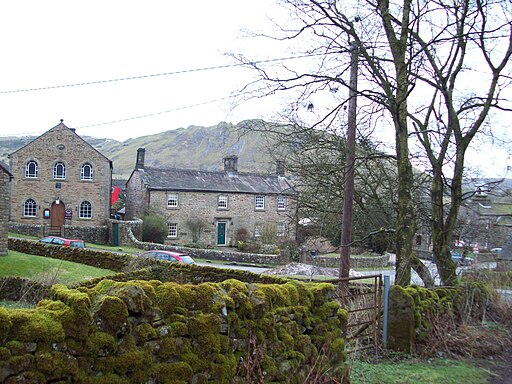
Hollinsclough pictured against the backdrop of Chrome Hill. This picture is taken from an ancient sunken track which drops down into Hollinclough from the west. The Methodist Chapel (dated 1801) is visible to the left and the old school house can be made out behind the trees to the right of shot. The majestic contours of Chrome Hill form an imposing backdrop.
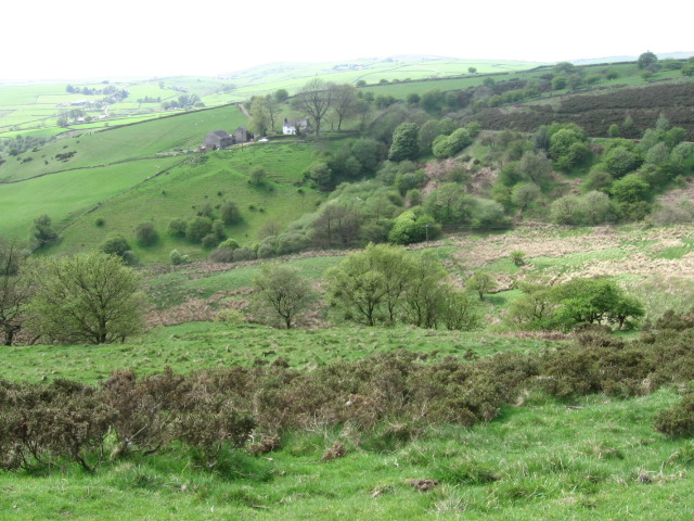
Hitter Hill from Parkhouse Hill. View eastwards from the summit of Parkhouse Hill. Glutton Grange is visible to the left of the ridge in the foreground.


