Moel Hebog
![]()
![]() This challenging walk climbs Moel Hebog from Beddgelert in the Snowdonia National Park. There's great views of the Welsh coastline and several peaks including Snowdon, Moel Siabod and the Nantlle Ridge. Please note that while this is a great walk the path is not always well defined and there is a degree of scrambling involved.
This challenging walk climbs Moel Hebog from Beddgelert in the Snowdonia National Park. There's great views of the Welsh coastline and several peaks including Snowdon, Moel Siabod and the Nantlle Ridge. Please note that while this is a great walk the path is not always well defined and there is a degree of scrambling involved.
The walk starts from the picturesque village of Beddgelert with its fine bridge crossing the River Colwyn and a number of good pubs for refreshment. You then follow footpaths out of the village and through a woodland section before ascending the mountain path. At the 783 m (2,569 ft) summit you will find a trig point where you can enjoy some stunning views of the surrounding peaks. The walk can be extended by continuing to the peaks of Moel yr Ogof and Moel Lefn .
The area is great for wildlife spotting. Look out for Buzzards, Red Kites and Perigrine Falcons as you make your way up the mountain.
If you'd like to continue your walking in the area then you could follow the Fishermans Walk along the stunning Aberglaslyn Pass. You could also visit the nearby Beddgelert Forest where you'll find miles of walking paths and mountain bike trails.
The Lon Gwyrfai multi user path skirts the eastern edge of the forest. The trail runs between Rhyd Ddu and Beddgelert along a nice easy surfaced path.
Postcode
LL55 4YW - Please note: Postcode may be approximate for some rural locationsMoel Hebog Ordnance Survey Map  - view and print off detailed OS map
Moel Hebog Open Street Map  - view and print off detailed map
Moel Hebog OS Map  - Mobile GPS OS Map with Location tracking
Moel Hebog Open Street Map  - Mobile GPS Map with Location tracking
Pubs/Cafes
The aptly named Hebog Cafe & Bistro is a great place to head for refreshments after your climb. The food is excellent and there's also a lovely river terrace to sit out and enjoy the surrounding mountainous scenery in the summer months. You can find it in the centre of Beddgelert on Caernarfon Road, with postcode LL55 4UY for your sat navs.
Also in Beddgelert is the excellent Caffi Gwynant. The cafe offers a wide range of foods prepared using local produce, daily specials, homemade cakes and desserts, local ales and free wi-fi. There's also an impressive outdoor glass canopy which is dog friendly.
Further Information and Other Local Ideas
Just a few miles to the west there's the splendid Cwm Pennant to explore. This stunning valley has a number of walking trails with fine views of the Afon Dwyfor and the surrounding mountains to enjoy.
For more walking ideas in the area see the Beddgelert Walks and the Snowdonia Walks pages.
Cycle Routes and Walking Routes Nearby
Photos

Snowdon from Moel Hebog

View South from the Summit of Moel Hebog. Beyond the summit plateau of Hebog, are the nearby hills of Moel Ddu, Mynydd Gorllwyn and Moel-y-Gest. Further away, across the Dwyryd, are the Harlech spit and the Rhinogydd Mountains.

Moel Hebog as seen from the main street Beddgelert

The Friths of the Western Slope of Moel Hebog. The North West Wales word "ffridd" (pl. "ffriddoedd) is a borrowing from the Old English "fyrhthe" meaning upland pastures. The modern English form of "fyrhthe" is "frith". Another Welsh variation of the word is "Ffrith"

Nant Colwyn from The Upper Slopes of Moel Hebog. The view encompasses the Beddgelert Forest, the Moel Eilio range and, in the background, the two Elidirs.Visible in the centre of the picture are the inter-twined A4085 and Welsh Highland Railway track.

The North East Ridge onto Moel Hebog. This view shows the upper slopes leading to the summit.

Nant Gwynant from the summit of Moel Hebog. The two lakes, Dinas and Gwynant, form prominent features in the landscape. The mountain in the distance is Moel Siabod.

Intrepid dog reaches the Summit Plateau!
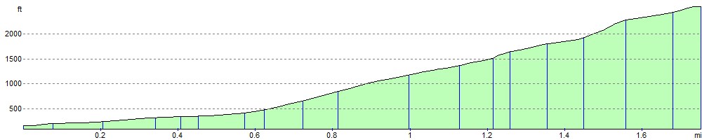
Elevation Profile