Oxfordshire Way

 Take a trip through Oxfordshire and enjoy rivers, canals, pretty villages and beautiful countryside on this lovely trail. The walk starts in Bourton on the Water in the Cotswolds and passes Shipton-under-Wychwood, Otmoor RSPB Nature Reserve, Shipton Under Wychwood, Wychwood Forest, Cornbury Park and Charlbury.
Oxfordshire Way Ordnance Survey Map  - view and print off detailed OS map
Oxfordshire Way Open Street Map  - view and print off detailed map
Oxfordshire Way OS Map  - Mobile GPS OS Map with Location tracking
Oxfordshire Way Open Street Map  - Mobile GPS Map with Location tracking
Pubs/Cafes
The Abingdon Arms is located just south of the Otmoor Nature reserve in the village of Beckley. It's a great option for some refreshments on the walk as the trail passes right through the village. The beer garden is probably the best in the country with fabulous views over the reserve from its elevated position. It's split into a terraced upper deck and lower deck making it an ideal place to relax on a warm day. You can find the pub in the little village of Beckley on the High St with a postcode of OX3 9UU for your sat navs.
The little hamlet of Christmas Common is a lovely place for a pit stop. Here you'll find the popular Fox and Hounds pub. The historic 500-year-old pub is situated on the top of Watlington Hill and is very walker and cyclist friendly. They have a good menu and a very pretty garden area for warmer days. You can find them at postcode OX49 5HL. They are also dog friendly.
The village of Middle Assendon has the Rainbow Inn. The typical country pub has a particularly lovely garden area which is ideal for warmer summer days. You can find them in the village at postcode RG9 6AU.
Further Information and Other Local Ideas
Near Henley you could take a small detour from the route to visit the splendid Greys Court. There's some lovely walks around this National Trust estate which includes a 16th century mansion, woodland and tranquil gardens.
For more walking ideas in the area see the Oxfordshire Walks and Chilterns Walks pages.
Cycle Routes and Walking Routes Nearby
Photos

Heading for the Menmarsh Guide Post.

Looking west from near Wyck Beacon over the Windrush Valley and Bourton-on-the-Water.

Here the path goes down the Chilterns western scarp face onto the Oxfordshire plain.

Autumn on the Oxfordshire Way near Henley

Middle Assenden village. View of this Chilterns village from the Oxfordshire Way.

Edge of Greenhill Copse. This small, dense area of woodland is close to the Evenlode river, and passed by part of the trail.

Bruern Abbey viewed from the Oxfordshire Way. One of the pleasures of walking is discovering the unexpected such as this imposing Georgian house which today is home to a boarding school for boys aged 7-13 with dyslexia or other specific learning difficulties. The house was built on the site of a Cistercian Abbey, founded in 1147. In 1947, the house was bought by Michael Aster, third son of Waldorf, 2nd Viscount Astor and his wife American born Nancy.

Bridge over a stream, Salmonsbury Meadows. On route from Bourton-on-the-Water to Wyck Rissington the trail crosses this bridge.
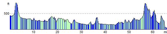
Elevation Profile