Oxfordshire Walks

Use the filter to show walks of a certain type such as woods, reservoirs, hills, long distance, country parks, canals and rivers.
In the spring walkers flock to the beautiful bluebell woods in the Oxfordshire area. Click the 'Woodland' button below to see these.
Use the links to view full route information including elevation profiles, interactive maps and GPS downloads.
You can also view an overview map of all the routes in the using the Oxfordshire Walk Map>>
*New* - Walks and Cycle Routes Near Me Map - Waymarked Routes and Mountain Bike Trails>>
| Filter: |
| Route Name | Photo | Distance | Description |
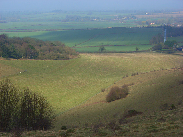
| Abingdon Circular Walk | 6.8 miles (11 km) | This circular walk explores the area to the south of this pretty Oxfordshire town. There's nice waterside paths along the River Thames and a visit to the neighbouring villages of Culham and Sutton Courtenay. The walk begins next to Abingdon Abbey in the town centre. The Abbey was originally founded in the 7th century is surrounded by the Abbey gardens which include ruins of an early 20th century folly. The monastic buildings include the Abbey Exchequer, the timber-framed Long Gallery and the Abbey bakehouse. The walk first heads east along the Abbey Stream to a weir on the Thames. Here you cross the river and follow the path south, passing Abingdon Bridge and Marina before coming to the village of Culham. The pretty village sits on a bend of the River and includes the Grade II listed Culham Manor which dates from the 15th century. There is also the 15th century Culham old Bridge which is Grade II listed. After exploring Culham the walk crosses the river at Culham Cut and proceeds to the nearby village of Sutton Courtenay. There's more fascinating old buildings here with a 12th century church and the 'Norman Hall' dating from the late 12th century. The Abbey or rectory house, dates from about 1300. The Wharf is also known as the former country residence prime minister H. H. Asquith. Asquith signed the declaration that took Britain into the First World War here. He is buried in the churchyard as is the famous author George Orwell. After leaving Sutton Courtenay the route heads west towards Drayton before turning north to Oday Hill. You then head through Caldecott to return to Abingdon. Here you can enjoy a stroll through the Market Place and visit the splendid Old County Hall which dates from 1862. The 15th-century St Helen's Church and Long Alley Almshouses are also well worth visiting. To continue your walking in the area you can head along the Thames Path east to Dorchester or north into Oxford on the Oxford River Walk. The long distance Oxford Green Belt Way also passes the town. Following it north west will take you to the pretty Farmoor Reservoir. The beautiful Harcourt Arboretum is also nearby. View Full Details>> | |
| Adderbury Circular Walk | 3.1 miles (5 km) | This three mile circular walk explores the countryside around the Oxfordshire villages of Adderbury and Bodicote. The walk makes use of various public footpaths surrounding the village with nice views of the Sor Brook and the surrounding countryside. The large village has two village greens, pretty cottages and St. Mary's Church which dates from the 13th century. The walk starts in East Adderbury, heading north past Twyford to the Sor Brook. You return through the countryside via Bloxham Grove and West Adderbury. There's lots of good options for continuing your walk. You could head a short distance east of the village centre and visit the Adderbury Lakes Nature Reserve. There's plenty of interesting flora and fauna to look out for here. The village is located just south of Banbury where there's several good walking options. You can also head east and pick up the Oxford Canal Walk and enjoy an easy walk along the towpath. Just to the south is the village of Deddington where you can enjoy another circular walk to Clifton. View Full Details>> | |
| Aston Rowant Nature Reserve | 5.3 miles (8.5 km) | Enjoy a circular walk around this wonderful nature reserve in the Chilterns and climb Beacon Hill on the way. The reserve is a splendid place for walking with miles of good paths taking you through woodland, chalk grassland and some lovely Chilterns countryside. It's a wonderful place for flora and fauna with flowers such as orchids, the Chiltern gentian and various wildflowers. The attractive mixed woodland includes beech, yew, and juniper. As for wildlife look out for Red Kites soaring above and butterflies such as the silver-spotted skipper and the Adonis blue. You may also see Dartmoor Ponies, Roe deer, feral goats and buzzards. This walk starts in the good sized Cowleaze Wood car park and takes you through pretty bluebell woods before reaching Beacon Hill where you can enjoy wonderful views of the reserve and Chiltern Hills. The route then descends on the Ridgeway, before passing Bald Hill and returning to the car park. If you'd like to continue your walking in this lovely area then you could head to the nearby Christmas Common and Watlington Hill where there is more beautiful flora and fauna. View Full Details>> | |
| Badbury Clump | 2.2 miles (3.5 km) | This walk explores Badbury Hill and the lovely wooded area of Badbury Clump near Faringdon. There is a car park next to the site just off the B4019 between Faringdon and Coleshill. You can then pick up the trails through the bluebell woodland to the summit of the hill where there is an Iron Age hill fort known as Badbury Camp. There are also nice views over the Vale of White Horse to the south and the Thames Valley. You can continue your walk in the surrounding Coxwell Wood. The route below is designed for walkers but the area is also popular with mountain bikers. There is a downhill course on the side of the hill with jumps, rollers, tabletops, drops and loamy corners. If you would like to continue your walking in the area then you could visit the nearby Buscot Park. There's 100 acres to explore with woodland, lakes and formal gardens. You could also try our Faringdon Circular Walk and enjoy a climb to the splendid Faringdon Folly where there are more great views to enjoy. View Full Details>> | |
| Banbury | 18.6 miles (30 km) | Explore the area surrounding the Oxfordshire town of Banbury on this long circular walk. The attractive market town is surrounded by some lovely countryside with miles of good footpaths to follow. It's a very rural area so the town makes for a great base for walkers. This walk makes use of waymarked long distance trails to visit some of the highlights of the area. This includes the Oxford Canal, Spiceball Country Park, the River Cherwell and a series of pretty villages. The walk starts in the centre of town and follows the Oxford Canal towpath south, before turning north east along the Jurassic Way. You cross the River Cherwell before heading through the countryside to Middleton Cheney, Chacombe and Upper Wardington. The route then passes the Grade I listed Edgcote House before coming to Chipping Warden where you pick up the Macmillan Way. This takes you west to meet up with the canal at Claydon Locks. Following the canal south through Cropredy then takes you back to Banbury, with nice views of the Cherwell as you go. Just before finishing the walk you will pass Grimsbury Reservoir and the pretty Spiceball Country Park with wild flower meadows, community woodland and several areas of native trees and shrubs. View Full Details>> | |
| Battlefields Trail | 19.9 miles (32 km) | This interesting walking trail links three of England's most significant Battlefields: Edgcote (1469) in Northamptonshire Cropredy Bridge (1644) in Oxfordshire Edgehill (1642) in Warwickshire It runs from Chipping Warden, Northamptonshire and ends in Kineton, Warwickshire, passing through some beautiful countryside along the way. The first section of the walk takes you from Chipping Warden to Upper Wardington. On the way you will pass the site of the Battle of Edgecote Moor which was fought during the Wars of the Roses in July 1469. The battle pitted the forces of Richard Neville, 16th Earl of Warwick, against those of King Edward IV. From Upper Wardington you continue west to Warmington, passing Cropedy where the Battle of Cropredy Bridge was fought on 29th June 1644 between a Parliamentarian army under Sir William Waller and the Royalist army of King Charles. This section also includes views of the Oxford Canal Walk and the River Cherwell. The final section then runs from Warmington to Kineton, passing through the beautiful Edghill Country Park. The park is set in the Cotswolds Area of Outstanding Natural Beauty and includes sixteen acres of mixed grass and primary Bluebell woodland. After passing through Ratley you soon come to the site of Battle of Edgehill. The battle was fought on Sunday, 23rd October 1642 and was the first pitched battle of the First English Civil War. Shortly after the walk then comes to at an end at the village of Kineton in Warwickshire. The Battlefields Trust Website has a wealth of information on this route and the history of the Battlefields of Britain. View Full Details>> | |
| Bernwood Forest | 3.4 miles (5.5 km) | This large area of woodland is located a few miles north east of Oxford city centre. It's a nice peaceful place to go for a walk if you are visiting the area. In the woods you'll find a number of footpaths including a Butterfly trail where you can look out for over 40 species of butterfly. You can start the walk at the car park on Oakley Road (postcode below). From here you can pick up the trails heading through Oakley Wood, Shabbington Wood and Waterperry Wood to the south. The Bernwood Jubilee Way also runs through the forest. This waymarked, long distance trail was devised to celebrate the Queen's Golden Jubilee. It runs for 61 miles and explores the area that was once The Royal Hunting Forest of Bernwood. View Full Details>> | |
| Bernwood Jubilee Way | 60.9 miles (98 km) | Explore the Ancient Royal Forest of Bernwood on this circular walk devised to celebrate the Queen's Golden Jubilee. Bernwood Forest includes a mixture of woodland, pasture, meadow, heathland and picturesque villages. The walk is often started at Brill and heads to Boarstall, Buckingham, Waddesdon, Nether Winchendon, Quainton and Thame. Highlights on the path include the National Trust owned Boarstall Tower. The attraction includes a 14th-century moated gatehouse and beautiful gardens. Near Oxford you will pass through Bernwood Forest itself. This peaceful area of woodland has a nice butterfly trail where you can look out for 40 different species of butterfly. Also of interest is Nether Winchendon House. This medieval Manor House is situated in a beautiful valley at the foot of the Chilterns and includes a 12th century Great Hall and a 16th century Dining Room. The walk also passes the beautiful Waddesdon Manor. View Full Details>> | |
| Bicester | 6.2 miles (10 km) | This walk from the Oxfordshire town of Bicester takes you through the countryside on the Cross Bucks Way visiting a series of pretty villages. You'll visit Marsh Gibbon and Poundon before finishing at Twyford where you can get the bus back to Bicester. There's much to enjoy as you make your way from Oxfordshire into Buckinghamshire and into the gently rolling agricultural landscape of Aylesbury Vale. You can pick up footpaths just east of the town centre that will take you through the countryside to the Cross Bucks Way. This long distance trail will take you to the Buckinghamshire village of Marsh Gibbon. Here you turn north towards Poundon, climbing to a height of over 300ft on Beacon Hill, where there are great views over Aylesbury Vale. The walk then descends into the village of Twyford where the route finishes. You can return to Bicester the same way or catch the bus back. The walk can be extended by continuing to Hillesden and Winslow. View Full Details>> | |
| Blenheim Park | 5 miles (8 km) | This circular walk starts at the magnificent Blenheim palace and takes you on a tour of the beautiful gardens. View Full Details>> | |
| Blewbury | 3.1 miles (5 km) | This walk from the Oxfordshire village of Blewbury visits the Iron Age Hillfort at Blewburton Hill. The hill is located a short distance to the east of the village and the walk includes a visit to the nearby village of Aston Tirrold. It's a 3 mile walk with a small climb and some nice views over the surrounding Oxfordshire countryside to enjoy on the way. The walk starts in the village of Blewbury, located just to the south of Didcot in the North Wessex Downs. From here you can pick up footpaths heading east up to Blewburton Hill. The univallate hill fort may have been occupied from the 4th century BC to the 1st century BC. Interesting finds at the site include Neolithic or Early Bronze Age flints recovered during excavations, and a polished stone axe found in the ditch near the entrance. Although there was no Roman occupation of the hilltop, a number of fragments of Roman pottery were recovered, dating to the 1st century AD, and the 3rd–4th centuries AD. After exploring the hill the walk descends to the village of Aston Tirrold where you could stop for refreshments at the local pub. The walk then returns to Blewbury on the same paths. To continue your walking in the area head south and pick up our Streatley Circular Walk which uses part of The Ridgeway National Trail. You could also head to nearby Goring and enjoy a riverside walk along the Thames Path. View Full Details>> | |
| Broughton Castle | 1.9 miles (3 km) | Enjoy a short stroll around Broughton Castle and Broughton park on this interesting walk in Oxfordshire. The moated manor house is very picturesque with nice footpaths running across the surrounding grounds with good views of the north Oxfordshire countryside. You can also enjoy a stroll around the pretty Ladies' Garden with its variety of plants and flowers. The castle is only open on certain days so please check the website link below for opening times. You can walk around the pretty Broughton park at any time for free though! The history of the house is very interesting with the core built in the early 14th century. It was a centre of opposition to Charles I and was besieged and damaged after the Battle of Edgehill in 1642. You can enjoy an excellent tour of the house with its grand rooms and furniture. The castle is located just a few miles south west of Banbury. If you are coming from Banbury on foot or by bike you could follow the Salt Way track from the southern outskirts of the town. View Full Details>> | |
| Burford Circular Walk | 5.6 miles (9 km) | This circular walk explores the countryside and woodland surrounding the Oxfordshire town of Burford. The interesting medieval town is situated in the Cotswold Hills near to the Gloucestershire border. There are nice footpaths to follow along the River Windrush and then into the farmland and woodland above the town. There is a good sized parking area just of the High Street in the town from which you can start your walk. Nearby is the Grade II Listed Burford Methodist Church, built in the early 18th century. If you head east out of the town you can pick up a public footpath along the River Windrush to Widford. Here you turn north and cross the river and head to the pretty village of Swinbrook. The village includes the church of Saint Mary the Virgin which dates from about 1200. After visiting Swinbrook the walk passes the site of the medieval village of Widford. St Oswald's church in Widford is Early English Gothic and dates from the 13th century. Widford was a substantial village in the Middle Ages but only the 16th-century manor house and a few other houses remain today. The route heads north from Widford, visiting some small woodland areas before arriving at the village of Fulbrook with its Norman church. The final section returns you to the finish point at Burford. You can extend your walk by continuing east from Swinbrook to Minster Lovell. It's a nice stroll along the river with the option of exploring the atmospheric ruins of the 15th century Minster Lovell hall. Just to the west of Burford you can pick up the Donnington Way long distance footpath in Great Barrington. Also nearby is the attractive town of Witney where you can visit the pretty lake and Church Grenn on our Witney Circular Walk. View Full Details>> | |
| Buscot Park | 0.9 miles (1.5 km) | Explore the delightful grounds and gardens surrounding this fine 18th-century house near Faringdon in Oxfordshire. You can stroll through attractive woodland and visit the lovely water gardens with ornate statues and fountains. There are several pretty lakes and a wonderful walled garden with a variety of plants, trees and flowers. Each section of the garden has been designed to represent a different season. Smaller gardens include a citrus garden, a rose garden and a swinging garden. If you would like to continue your walking in the area then you could visit the nearby Badbury Clump. Here you will find bluebell woodland and Bradbury Hill where there is an Iron Age hill fort known as Badbury Camp. There are also nice views over the Vale of White Horse to the south and the Thames Valley. You could also follow the Thames Path west and visit the attractive town of Lechlade. View Full Details>> | |
| Chalgrove | 3.3 miles (5.3 km) | The village of Chalgrove is located in Oxfordshire, near to neighbouring Stadhampton and the city of Oxford. The pretty village includes a number of picturesque thatched cottages around a villlage green. View Full Details>> | |
| Charlbury Circular Walk | 4 miles (6.5 km) | This circular walk uses part of the Oxfordshire Way long distance trail to explore the area around the Oxfordshire town of Charlbury. View Full Details>> | |
| Chiltern Way | 124.3 miles (200 km) | This is the original 125 mile circuit of the Chilterns AONB taking you through Hemel Hempstead, Chalfont St Giles, Marlow, Hambleden, Turville, Fingest, Bix Bottom, Ewelme, the Ridgeway, Stokenchurch, Great Hampden, Aldbury, the Dunstable Downs Country Park, Sharpenhoe Clappers and Harpenden. The main attractions on the route are the series of delightful villages with their ancient churches, pretty village greens and fascinating museums. The Chilterns countryside is also beautiful with rivers, canals and the rolling hills to enjoy. View Full Details>> | |
| Chiltern Way Berkshire Loop | 28 miles (45 km) | This walk runs from the outskirts of High Wycombe to Crowsley Park, near Henley on Thames. The route includes several long sections along the River Thames where you will pass a series of delightful riverside towns and villages. These include Cookham and then Henley-on-Thames, home to the famous annual regatta. View Full Details>> | |
| Chipping Norton | 23 miles (37 km) | This popular Oxfordshire market town is a great base for exploring the Cotswold Hills. This long circular walk makes use of three long distance waymarked trails which run through the area surrounding the town. You will follow sections of the Wychwood Way, the Shakespeare's Way and the D'arcy Dalton Way to visit a series of pretty villages including Cornwell, Churchill, Shipton Under Wychwood, Ascott-under-Wychwood and Chadlington. View Full Details>> | |
| Claude Duval Bridleroute | 63.4 miles (102 km) | This shared walking and cycle path runs from Quainton, near Aylesbury in Oxfordshire to Great Barrington in the Cotswolds. This route is named after the well-known local highwayman, Claude Duval. It starts at Quainton and passes Stratton Audley, Bicester and Bucknell before crossing the Oxford Canal near Woodstock. The route then heads towards Chipping Norton and then Spelsbury where you join the River Evenlode for a short waterside stretch to Ascott d'Oyley. You then head onto Great Barrington via Fifield. View Full Details>> | |
| Coleshill Estate | 7.1 miles (11.5 km) | This National Trust owned estate near Swindon has miles of lovely walking trails taking you through attractive parkland and farmland. The walk starts from the National Trust Estate car park at Coleshill. You then head south through the countryside to the woodland of Waterloo Copse and on to Waterloo Lodge. You continue past the 18th century Strattenborough Castle and then to Ashencopse cottage and Ashen Copse Woods. The route then heads to the prettty village of Great Coxwell where you will find the interesting 13th-century monastic barn. After admiring this old Costwold stone structure the route then heads west through the countryside back to Coleshill. The route passes near to Badbury Clump. View Full Details>> | |
| Cotswold Round | 216.9 miles (349 km) | Travel through some of the most beautiful countryside and prettiest villages in England on this circular walk. You will visit a series of classic Cotswolds towns and villages including Cheltenham Spa, Winchcombe, Stanton, Broadway, Chipping Campden, Moreton-in-Marsh, Stow on the Wold and Bourton on the Water (video below). There is much to enjoy with lush green countryside, historic houses, beautiful parks, woodland sections and homely country pubs for refreshments. View Full Details>> | |
| Cotswold Water Park | 10.3 miles (16.5 km) | This fabulous attraction has numerous waterside cycling and walking paths taking you around the park's 150 lakes. There are 40 square miles to explore within the water park but with the Thames Path National Trail and National Cycle Route 45 running through the park there is great scope for continuing your exercise along these trails (bike hire is available in the park). There is a wide variety of wildlife to see too - look out for otters, water voles and beavers. The western section of the park shown in the map is located between Swindon and Cirencester. There is also an eastern section located near Fairford and Lechlade. Our Fairford Walk starts from the town and explores that section of the park before heading to Lechlade for a stroll along the Thames. View Full Details>> | |
| Darcy Dalton Way | 66.5 miles (107 km) | This long distance walking trail runs through the Oxfordshire countryside from Wormleighton Reservoir to Wayland's Smithy near Ashbury. View Full Details>> | |
| Deddintgon Circular Walk | 5.6 miles (9 km) | A nice circular walk through the countryside surrounding the Oxfordshire village of Deddington. The route makes use of bridleways and footpaths to visit the village of Clifton and explore part of the Cherwell Valley. There's lovely rolling north Oxfordshire countryside and great views from the high points north of the village. Highlights on the route include old Paper Mill Cottages from the 18th century, the thatched 17th century pub in Clifton and views of the River Swere. If you would like to extend your walk then you could pick up the Oxford Canal Walk near Clifton. Following the towpath north will take you to Kings Sutton. Also nearby is Stoke Wood which includes an impressive avenue of Corsican pines and a flowers including orchids and bluebells. The village is located just to the south of Banbury where there are several good trails to try. The large village of Adderbury is also nearby. You could try our circular walk which visits the Sor Brook. View Full Details>> | |
| Didcot | 7.5 miles (12 km) | The Oxfordshire town of Didcot has some nice trails to follow into the surrounding Chilterns countryside. This walk visits some of the highlights of the area using a mixture of country lanes, public footpaths and waymarked long distance trails. You'll visit the famous Didcot Railway Centre, the scenic hills of Wittenham Clumps, the River Thames and the interesting Roman town of Dorchester. The walk starts at Didcot Junction in the town centre and follows a path around the railway centre. A shared cycling and walking trail then takes you through the countryside to the village of Long Wittenham. Here you can take a small detour to visit the River Thames around Clifton Cut. The route heads through the village and then follows a country lane to Little Wittenham and the Wittenham Clumps. The 'clumps' include Round Hill at 390 feet (120 m) and the 350 feet (110 m) Castle Hill which is about 380 yards (350 m) to the south-east. The Clumps are one of the most visited outdoor sites in Oxfordshire, attracting over 200,000 visitors a year. From the hill summits there are fine views over the surrounding countryside. After exploring the hills the route then heads through Little Wittenham Wood to the River Thames. You cross the river close to the pretty Day's Lock before following a country path to Dorchester. A must see in the town is the magnificent Dorchester Abbey. The abbey dates from 1140 and contains a fascinating museum detailing the history of the area. View Full Details>> | |
| Donnington Way - Cotswolds Pub Walk | 61.5 miles (99 km) | Visit the 15 pubs of the Donnington Brewery on this super pub walk through the Cotswolds. The walk starts in Stow on the Wold and heads to a series of delightful Cotswold villages including the famous picture postcard settlement of Bourton on the Water. View Full Details>> | |
| Dorchester Circular Walk | 8.7 miles (14 km) | The delightful Oxfordshire town of Dorchester on Thames has some lovely footpaths to follow through the surrounding countryside and woodland. This circular walk visits the River Thames, Little Wittenham Wood and Castle Hill Iron Age Hillfort. There's much to enjoy in the area, with riverside paths, peaceful woodland trails and wonderful views from the Wittenham Clumps hills on the southern side of the Thames. A must see in the town is the magnificent Dorchester Abbey. The abbey dates from 1140 and contains a fascinating museum detailing the history of the area. The walk starts in the town centre and heads south through the town before turning west towards Little Wittenham. Here you cross the Thames and follow paths through Little Wittenham Woods to Wittenham Clumps. These two hills are a popular local attraction, offering wonderful views of the Oxfordshire countryside from the high points. After exploring the site of an Iron Age Hillfort on Castle Hill, the walk descends through farmland to Shillingford where you cross the Thames on the 19th century bridge. Here you pick up the Thames Path to take you back along the river before turning north to return to the town. To extend your walking in the area, simply head south along the riverside path to Wallingford where you can visit the ruins of the 11th century Wallingford Castle and pick up The Ridgeway National Trail. View Full Details>> | |
| Faringdon Circular Walk | 5 miles (8 km) | This circular walk around the Oxfordshire town of Faringdon, visits Faringdon Folly and the village of Littlelworth. The route uses public footpaths to take you through the countryside surrounding the town before climbing Folly Hill where there are lovely views over the surrounding area. The Folly is surrounded by 4 acres of attractive woodland with a delightful sculpture trail which is great for children. On certain days you can climb the tower for far reaching views over the Oxfordshire countryside. Look out for wildlife including Red Kites, Buzzards and various woodland birds as you make your way around the site. If you would like a shorter walk just use the last section of this route to climb to the folly from the town. To extend your walking in the Faringdon area you could head to the nearby Badbury Clump. Here you will find a hill top Iron Age Hillfort, bluebell woods and nice views over the Vale of White Horse. Badbury Hill and Badbury Forest are located just to the west of the town. Just to the north of Badbury Hill you will also find the lovely Buscot Park where there's 100 acres of woodland, lakes and formal gardens to explore. To the north of the town you can pick up the Thames Path and enjoy a riverside walk to Lechlade. View Full Details>> | |
| Farmoor Reservoir | 3.7 miles (6 km) | Enjoy an easy circular walk around this pretty reservoir near Oxford. The walk starts from the car park and visitor centre on the eastern side of the lake. You then pick up the path which takes you to attractive woodland, Thames riverside meadows and nature reserves. The reservoir is an excellent place for birdwatching. Look out for Ospreys, Red Throated Diver and a variety of other water loving wildlife in the wetland nature reserves situated at the northern end of the site. It's a nice varied walk which runs for nearly 4 miles with great views of the surrounding countryside and the River Thames. You can also see a variety of watersports taking place for most of the year. The Oxford Green Belt Way and the Thames Path both run past the reservoir so you could pick up one of these long distance routes to continue your walk. Just to the east is the delightful Port Meadow with walking trails by the Thames and Oxford Canal. Less than a mile to the north east you will find Wytham Woods. There's 1000 acres of mixed woodland to explore on a network of footpaths here. View Full Details>> | |
| Goring | 11.2 miles (18 km) | This riverside village in South Oxfordshire is ideally located for walking with two National Trails passing through the area. Both The Ridgeway and the Thames Path head through the village and are a great way to explore the river and the surrounding countryside. The noteworthy village was named Oxfordshire's Village of the Year in 2009 and also has an interesting church with parts dating from the 13th century. This circular walk uses both waymarked trails to take you along both sides of the River Thames. You'll pass through two counties as in this area the river bisects Oxfordshire and Berkshire. Starting on the eastern side of the river at Goring Bridge, the route first heads north along the Ridgeway to South Stoke and North Stoke. At Mongewell you cross to the other side, although you could continue to nearby Wallingford if you prefer. On the western side of the river you pick up the Thames Path and follow it south. You'll pass the Berkshire settlements of Moulsford and Streatley, before crossing Goring Bridge to return to Goring. At Streatley you will pass the lovely riverside Swan Inn, which is a great place to sit outside and enjoy refreshments in the summer months. To continue your walking in the village you can pick up the The Swan's Way long distance trail. The shared cycling and walking trail starts in Goring and runs all the way to Salcey Forest. View Full Details>> | |
| Great Tew | 2.2 miles (3.5 km) | This circular walk visits the delightful Cotswolds village of Great Tew. There's some nice walking trails to follow around the Great Tew Estate and into the surrounding countryside. The route runs for just over 2 miles, with lovely views of the estate parkland and the surrounding Cotswolds countryside. Start the walk from the car park in the village and then head east along the footpaths around Great Tew Park. The paths then loop round the estate before returning to the village. On the way you will pass the noteworthy parish church. The church was originally Norman, and the south doorway from about 1170 survives from that period. It was rebuilt in the 13th century with the arcades of stone pillars inside the building and the south porch still in existence. The church is reached by passing through a splendid 17th-century gateway. Take time to explore the village and you will pass lots of lovely 17th century thatched cottages. You can then enjoy refreshments at the Falkland Arms public house which has a nice outdoor seating area. View Full Details>> | |
| Harcourt Arboretum | 1.2 miles (2 km) | This beautiful arboretum near Oxford has a series of well laid out footpaths to try. There's 130 acres to explore with wildflower meadows, rhododendrons and bluebell woods. In the arboretum you will find giant redwoods, azaleas and monkey-puzzle trees. Many of the trees have been introduced from the Pacific North West region of North America. The lovely paths take you to the Serpentine Ride and peaceful glades. It really is a spectacular sight in autumn while in spring there are beautiful carpets of bluebells. In addition to the woodland there is a 67 acre wildflower meadow with views of the surrounding countryside. Look out for a variety of birdlife and the resident peacocks as you make your way through the grounds. Harcourt is located near to the Thames Path so this is a good option if you would like to extend your walk. Both Abingdon and Oxford are nearby. View Full Details>> | |
| Henley-on-Thames | 14 miles (22.5 km) | The popular market town of Henley-on-Thames has a number of excellent waymarked trails to try. The riverside town is a very pretty place and home to the famous Henley Regatta. The rowing event takes place every year over the first weekend in July. Look out for the Grade I listed Henley Bridge as you make your way through the town. The five arched bridge across the river thames was built in 1786. The parish church of St Mary the Virgin dates from the 16th-century while the The Old Bell dates from 1325. The town can be accessed by train from Twyford and there are direct trains from London Paddington in peak hours. This long circular walk makes use of the Thames Path, the Chiltern Way and the Oxfordshire Way to take you on a tour of the countryside surrounding the town. These three long distance footpaths all pass close to the town. They are a good way of exploring the area as they are waymarked and of a good quality. The walk starts in the town centre near the river and follows the Thames Path south to Bolney Court. This section passes Park Place, Marsh Lock weir and Ferry Eyot island. Here you turn west along the Chiltern Way and head towards the village of Binfield Heath via Harpsden Wood. You then turn north and head past the woodland of the BBC owned Crowsley Park estate. From the public footpaths there are views of Crowsley Park House, a Grade II listed 18th century mansion house. After leaving Crowsley Park you continue north to the splendidly named Rotherfield Peppard village. Here you will find the lovely Peppard Common which has nice walking trails through woodland, lowland heath and grassland. The walk continues through the fringe of Nettlebed Woods before turning south along a section of the Oxfordshire Way. This takes you past the villages of Bix and Middle Assendon before coming to Henley Park. Shortly after you return to the town and the finish point. View Full Details>> | |
| Heythrop Park | 2.3 miles (3.7 km) | This walk takes you to Heythrop Park which lies just to the south of the village of Heythrop in Oxfordshire. View Full Details>> | |
| Iffley Lock and Meadows Walk | 1.2 miles (2 km) | This circular walk takes you around the pretty Iffley Lock and Meadows next to the River Thames in Oxford. The walk starts from the St Mary the Virgin Church in the village of Iffley, just south of Oxford. The church is noteworthy as it is Grade I listed and built c.1160 by the St Remy family, probably financed with funds from the de Clintons of Kenilworth Castle. The building has not been changed too much over the centuries, retaining its Norman round-arched windows and doorways. From the village it is a short walk west to the river and the lock. The original lock was built by the Oxford-Burcot Commission in 1631 and the Thames Navigation Commission replaced this in 1793. The lock has a set of rollers to allow punts and rowing boats to be moved between the water levels. At this point you can cross the western side and explore the lovely Iffley Meadows. There's nice waterside paths here along the Weir Mills Stream and views of cattle grazing on the meadows. The meadows are also a nature reserve notable for their large population of snake's head fritillaries. On the eastern section of the meadows you can pick up a section of the Thames Path and follow it south along the river to Iffley. View Full Details>> | |
| Jurassic Way | 87.6 miles (141 km) | This walk follows the Jurassic limestone ridge from Banbury to Stamford passing through Northamptonshire, Oxfordshire and Lincolnshire. The walk includes a stretch along the Oxford Canal from Banbury and another waterside stretch along the Grand Union Canal near Braunston. There's nice woodland trails through Fineshade Woods in the ancient Rockingham Forest area and you will also enjoy fine views of the River Welland as you approach Stamford. The route passes through a series of picturesque towns and villages including Wardington, Catesby, Welford, Braunston, Ashby St Ledgers (with its impressive Manor House), West Haddon and Middleton. You'll also pass close to Naseby Battlefield, site of the famous Battle of Naseby in the English Civil War in 1645. There's a section along Welford and Sulby Reservoir here too. View Full Details>> | |
| Kidlington Circular Walk | 3.9 miles (6.3 km) | This walk takes you around the pretty village of Kidlington near Oxford. On the way you'll enjoy nice views of the River Cherwell, the Oxford Canal and the surrounding countryside. The route runs for about 4 miles on fairly flat footpaths with a couple of small climbs on the way. The walk starts from the St Mary The Virgin Church car park on the outskirts of the village. The noteworthy church dates from the 13th century and includes fine medieval stained glass with a 220-foot (67 m) spire known as 'Our Lady's Needle'. It is a Grade I listed building. From the church car park you can pick up footpaths heading north over the river towards the little village of Hampton Poyle. You then turn north west to follow another path through the countryside to Hampton Gay. Here you cross the river and the canal to reach Shipton-on-Cherwell. You can then pick up a nice waterside section along the canal towpath to the little hamlet of Thrupp Canal Walk where you could stop for refreshments at the The Boat Inn. The final section then takes you from Thrupp along the Cherwell back to the church. View Full Details>> | |
| Kingham-Bledington-Foxholes | 5.9 miles (9.5 km) | The delightful Cotswolds village of Kingham was voted 'England's Favourite Village' in 2006. It's rows of limestone cottages and pretty village greens make it a must see if you are visiting the area. This lovely walk takes you through the Kingham streets before visiting the nearby village of Bledington and Foxholes Nature Reserve. The village is notable for the church of St Andrew which has a 14th-century Gothic west tower with a 15th-century top. It is also accessible from the train station which sits on the Cotswold Line. You can catch direct trains right to the village from London Paddington, Worcester, Reading and Oxford. The walk starts in the centre of the village and heads south west through the countryside to Bedlington. In the village you will find the parish church of St Leonard which dates from 1170. There's also the 16th-century King's Head Inn which overlooks the village green. The inn was awarded Dining Pub of the Year by the Good Pub Guide in 2001. At Bedlington you pick up the Oxfordshire Way long distance trail to take you south to Foxholes Nature Reserve. Here you can enjoy views of the River Evenlode before trying the woodland trails in the reserve. Look out for spring bluebells, foxgloves, woodland birds and over 200 species of fungi. After exploring the reserve you can return to the village the same way or turn it into a longer circular walk by picking up various footpaths through the countryside. The village is located very close to Chipping Norton where you can try our Chipping Norton Circular Walk which visits a number of nearby villages. You could also pick up one of several long distance trails including Oxfordshire Way, the North Cotswold Diamond Way and the Macmillan Way. View Full Details>> | |
| Lambourn Valley Way | 21.7 miles (35 km) | Travel from Oxfordshire into Berkshire along the Lambourn Valley Way and enjoy woodland, parkland and a series of quaint towns and villages. The walk starts at the Bronze age fort at Uffington Castle and the distinctive prehistoric Uffington White Horse hill figure. From here you head south across the Lambourn Downs before following the River Lambourn through Lambourn, Boxford and Speen before a lovely stretch along the Kennet and Avon Canal takes you into Newbury. View Full Details>> | |
| Macmillan Way | 290.2 miles (467 km) | This epic long distance path links Boston in Lincolnshire to Abbotsbury in Dorset. It is promoted to raise money for the charity Macmillan Cancer Relief.
The route starts from Boston and then runs across the Fens to Bourne before joining the limestone belt. You then head to Stamford and then along the shoreline of Rutland Water. You'll also pass through the medieval market town of Oakham where there's some wonderful old architecture at the Norman castle and the 16th century Oakham School. The trail then heads south and west via Warmington to Stow-on-the-Wold, then into the Cotswolds via Cirencester and Tetbury to Bradford-on-Avon. After leaving the Cotswolds you follow the path through Somerset passing Castle Cary before entering Dorset and the final section to Abbotsbury via Sherborne. The route joins with other popular trails including the Viking Way at Oakham, the Thames Path National Trail near Thames Head and with the South West Coast Path towards the end of the route. View Full Details>> | |
| Mapledurham House | 4.3 miles (7 km) | The Mapledurham estate is a wonderful place for a relaxing afternoon walk. The house is located on the River Thames with the picturesque Old Watermill right beside it. The mill is still operational and dates from the 15th century. The route below is circular, starting at the house and taking you on a tour of the woodland and countryside in the estate. The park is located near Caversham in Oxfordshire. The estate is located on the Thames Path so you could continue your walk along the river. For example if you head east you will soon come to the delightful Caversham Court Gardens. Heading west will take you to the pretty village of Pangbourne where you can visit the delightful water meadows and enjoy a stroll along the River Pang. View Full Details>> | |
| Minster Lovell | 3.1 miles (5 km) | This circular walk explores the pretty Oxfordshire village of Minster Lovell with its old hall, thatched stone cottages and riverside footpaths. The highlight of the walk is a visit to Minster Lovell Hall built in 1440. Here you will find the ruins of the hall surrounded by an extensive estate and bordered by the River Windrush. The atmospheric ruins include an ornamented entrance porch, south west tower and dovecote. After exploring the hall you can continue along the river to the nearby village of Crawley. Here you will find two Bronze Age bowl barrows near Blindwell Wood and a 19th century church. There are also two pubs where you can enjoy refreshments at the half way point of the walk (more details below). From Crawley another public footpath will then bring you back to Minster Lovell through the countryside. To extend your walking in this area simply head east and visit the pretty town of Burford where there are more nice riverside paths and historic buildings. The village is also located just west of Witney so you could start the walk from the town and follow the river to the old hall. You could also try our Witney Circular Walk which takes you along the river to Witney Lake and Meadows. View Full Details>> | |
| Otmoor | 4.7 miles (7.5 km) | This lovely RSPB nature reserve consists of wet meadows, grassland and reedbeds. The area attracts thousands of wildfowl and waders such as lapwings and redshanks. You can also look out for a variety of dragonflies and butterflies. This circular walk follows good footpaths around the reserve with views of the River Ray and the surrounding Oxfordshire countryside. You can also bring your bike to the reserve but please keep to the bridleways and public footpaths but avoid the visitor trail and permissive paths. The Oxfordshire Way runs past the reserve so you could pick this up to continue your walk. If you prefer you can visit the reserve by following the Oxfordshire Way from nearby Beckley. View Full Details>> | |
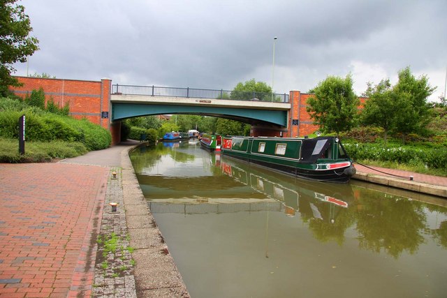
| Oxford Canal Walk | 77.1 miles (124 km) | Follow the Oxford Canal from Oxford to Coventry on this splendid waterside walk. You follow the towpath of the canal for the duration of the route meaning this is a fairly easy walk (providing you don't do at all at once!) You will pass through a series of delightful villages including Thrupp, Lower Heyford, Banbury, Cropredy, Braunston Turn and Rugby before finishing at Hawkesbury Junction in Coventry. The peaceful south Midlands countryside, a series of pretty locks and several excellent canal side pubs make this walk a fantastic experience. Highlights include the delightful Port Meadow at the start of the route in Oxford, great views of the River Cherwell through Oxfordshire and the stunning gardens at Rousham Park. View Full Details>> | |
| Oxford Green Belt Way | 52.2 miles (84 km) | The Oxford Green Belt Way was created by CPRE Oxfordshire to celebrate its 75th anniversary and 50 years of Oxford's Green Belt. The circular walk takes you through some lovely Oxfordshire countryside and historic villages, with peaceful waterside sections along the River Thames, the River Cherwell and the Oxford Canal. The walk begins on the outskirts of Oxford and visits Horspath, Garsington, Abingdon, Kidlington and Beckley. There are excellent views of Oxford’s Dreaming Spires, Otmoor, Foxcombe Hill and Wytham Woods. Attractions on the route include Harcourt Arboretum at Nuneham Courtenay. Here you will find a 10-acre woodland and a 37-acre meadow full of wild flowers. The route passes the RSPB nature reserve at Otmoor where you can enjoy a nature trail and look out for thousands of wildfowl. Near Horspath you will pass through Shotover Country Park with its ancient woodland, flowery meadows, marshes, ponds and bracken-covered slopes. You can climb Shotover Hill for wonderful views of the surrounding countryside. There are also lovely waterside stretches along the River Thames, the Oxford Canal and around Farmoor Reservoir. View Full Details>> | |
| Oxford River Walk | 8.1 miles (13 km) | Enjoy a nice easy stroll from Oxford to Abingdon on this walk along a nice section of the Thames Path. It's a lovely area with the University College boathouses, a series of pretty islands, rushing weirs and some historic locks. The walk starts from Folly Bridge next to Christchurch Meadow. The bridge was erected in 1825–27, to designs of a little-known architect, Ebenezer Perry (died 1850), who practised in London. From here you pick up the river path on the south side of the bridge and head south along the Isis. The Isis is the name given to the part of the River Thames above Iffley Lock which flows past Christ Church Meadow and is the focal point of rowing for Oxford University. View Full Details>> | |
| Oxfordshire Way | 67.1 miles (108 km) | Take a trip through Oxfordshire and enjoy rivers, canals, pretty villages and beautiful countryside on this lovely trail. The walk starts in Bourton on the Water in the Cotswolds and passes Shipton-under-Wychwood, Otmoor RSPB Nature Reserve, Shipton Under Wychwood, Wychwood Forest, Cornbury Park and Charlbury. View Full Details>> | |
| Palladian Way | 118.1 miles (190 km) | Walk from Buckingham to Bath through the beautiful countryside of Buckinghamshire, Gloucestershire, Oxfordshire and Wiltshire on this trail named after Andre Palladio's Italian architecture. The walk runs from Buckingham to Brackley, Woodstock, Burford, Cirecncester, Malmesbury and then Bath. You can enjoy waterside sections along the Oxford Canal near Kirtlington and along the River Windrush between Woodstock and Burford. There is also a section through the beautiful Cotswolds countryside around Burford. Other route highlights include the National Trust Owned Stowe Park, and the magnificent Blenheim Palace - birthplace of Winston Churchill . View Full Details>> | |
| Port Meadow | 3.7 miles (6 km) | This lovely area in Oxford has nice walking trails along the Thames and attractive meadowland with grazing ponies and horses. The walk starts from the car park near Jericho and follows the Thames through the meadow to Gorstow Lock and the remains of Gorstow Abbey. You then head past Wolvercote Common before returning to the car park. It's a really pretty area with carpets of buttercups in the summer and a variety of wildlife to look out for. Horses, cattle and geese graze the meadow and various birds can be spotted around the water and meadow. It is thought that this area of the Thames is where Lewis Carroll first made up the story of Alice's Adventures in Wonderland. If you'd like to continue your waterside walking in the area then you could pick up the Oxford Canal or the Thames Path which run past the meadow. Just to the west you will find the expansive Wytham Woods where there's 1000 acres of mixed woodland to explore. You can virtually explore the area using the street view link below! View Full Details>> | |
| Reading to Henley | 9.9 miles (16 km) | Enjoy an easy riverside walk along the Thames Path on this walk from Reading to Henley-on-Thames via Sonning. The route runs for just over 9 miles so the walk should take about 3-4 hours. At the end of the walk you can catch a train or bus back to Reading. It's a lovely section of the river with pretty locks, little islands and great views of the surrounding countryside. The walk starts on Caversham Bridge in the centre of Reading. From here you head east along the riverside path to Sonning, passing the Caversham Lakes. These include the Redgrave-Pinsent Rowing Lake named after the Olympic rowers Sir Steve Redgrave and Sir Matthew Pinsent. The GB rowing squad and the Oxford University boat race team train on the lake. The route continues to the village of Sonning which is a particularly pretty area. Here you'll pass Sonning Lock and Sonning Bridge. The photogenic arch bridge was completed in 1775, to replace an earlier wooden bridge. The next stage takes you towards Shiplake where there's another lock, a series of little islands in the river and views over to the historic settlement of Wargrave on the opposite side of the water. View Full Details>> | |
| River Cherwell | 2.5 miles (4 km) | Enjoy a nice waterside walk along the River Cherwell in Oxford. The circular route takes you from the University parks to Summertown before visiting nearby Marston. The walk starts from the Rainbow Bridge, a distinctive curved footbridge over the River Cherwell in the University Parks. The parks are a large parkland area slightly northeast of the city centre in Oxford. From the Rainbow bridge you can see punts travelling along the river in during the summer. On the eastern side of the arched bridge you can pick up a footpath heading north toward Wolfson College, one of the constituent colleges of the University of Oxford. There is a footbridge across the river which leads into the college grounds here. After passing the college you have the option of continuing north toward Cutteslowe where there is a nice pubic park. This route heads east toward Marston where you head south through the Oxford suburb. A path then follows the Marston Brook across the meadows before returning you to Rainbow Bridge. View Full Details>> | |
| Rousham Park | 0.9 miles (1.5 km) | Explore the beautiful gardens surrounding this 17th century country house near Oxford. There are wide lawns, a variety of beautiful flowers, tranquil ponds, classical temples, follies and ornate statues. There are also nice shady woodland paths and meadows with grazing cattle. The gardens are surrounded by beautiful Oxfordshire countryside with the River Cherwell and the Oxford Canal running past the site. It's a beautiful place and is perfect for a relaxing afternoon stroll in lovely surroundings. You can extend your walking in the area by picking up the Oxford Canal Walk and heading to Upper And Lower Heyford. View Full Details>> | |
| Shakespeare's Way | 146 miles (235 km) | This walk follows a route that Shakespeare may have taken when travelling between Stratford-upon-Avon and London. The path passes through the Chilterns, Oxford, Blenheim Park, the Cotswolds, the valley of the River Stour and the Thames Valley making for a beautiful and varied walk. There are lovely waterside stretches along the Oxford Canal and the River Thames into London. The walk is waymarked with a logo of Shakespeare's head. View Full Details>> | |
| Shotover Country Park | 3.1 miles (5 km) | Shotover country park is a 289 acre site located on the outskirts of Oxford. It encompasses ancient woodland, flowery meadows, marshes, ponds, bracken-covered slopes and Shotover Hill where you will find splendid views across South Oxfordshire. The Oxford Green Belt Way runs through the park providing an opportunity to explore the area further. View Full Details>> | |
| Spiceball Country Park | 1.6 miles (2.5 km) | Enjoy an easy stroll along the Oxford Canal and the River Cherwell in this country park in Banbury. In the park you will find wildlife, wild flower meadows, community woodland and several areas of native trees and shrubs. The park is conviniently located in the centre of the town, near to the rail station and bus station. It's easy to extend your walk by continuing along the canal towpath. You could also try our Banbury Circular Walk to explore the countryside surrounding the town. It makes use of the Jurassic Way, Macmillan Way and Oxford Canal Walk long distance footpaths to take you on a tour of the pretty villages surrounding the town. View Full Details>> | |
| Stoke Wood | 0.9 miles (1.5 km) | These ancient woods are located near Bicester in Oxfordshire. They consist of both mixed broadleaf and exotic conifer trees with nice footpaths to follow around the site. Highlights in the woods include an impressive avenue of Corsican pines and a flowers including orchids and bluebells. Wildlife to look out for include tawny owl and butterflies such as white admiral and silver-washed fritillary. You can start your walk from the Stoke Woods car park at the north eastern end of the woods. It's located less than a mile west of the village of Stoke Lyne. To extend your walking in the area you can head to Stratton Audley and pick up the long distance Cross Bucks Way. A few miles west of the woods you can pick up the Oxford Canal Walk at Somerton. There's also the option of exploring the Cherwell Valley around the village of Deddington. View Full Details>> | |
| Thame | 8.9 miles (14.3 km) | The market town of Thame is well served by a number of public footpaths branching out into the surrounding countryside. The area has nice riverside trails, woodland areas, nature reserves. This circular walk around Thame uses the Thame Valley Walk, the Oxfordshire Way and other public footpaths to explore the countryside surrounding the town. On the way you'll visit the River Thame, the village of Shabbington, Ryecote Park, Moreton and the Cuttle Brook Nature Reserve. View Full Details>> | |
| Thame Valley Walk | 14.9 miles (24 km) | Follow the River Thame from Albury in Oxfordshire to Aylesbury in Buckinghamshire on this pleasant waterside walk. The route runs for a distance of about 15 miles on fairly flat paths so could be completed in a day by walkers with a good level of fitness. The walk passes Shabbington, Long Crendon, Chearsley, the 12th century Notley Abbey and Nether Winchendon. The Thame Valley is home to an abundance of wildlife including reed warblers, cuckoos, damselflies and butterflies. Plant life and woodland also thrives making for a interesting walk for the naturalist. Highlights on the path include the 15th century Nether Winchendon house, the attractive market town of Thame and the 15th century church of St Mary at Long Crendon. View Full Details>> | |
| The Swan's Way | 65.2 miles (105 km) | The Swan's Way long distance bridleroute runs from Salcey Forest in the north to Goring on Thames in the south, a distance of 65 miles (105km). From the Northants border, the route crosses the Vale of Aylesbury to meet the Ridgeway near Princes Risborough and then follows the chalk slopes of the Chilterns to the Thames at Goring. View Full Details>> | |
| Three Downs Link | 101.9 miles (164 km) | This is a walking and cycling path following bridleways through Hampshire, Berkshire, Wiltshire and Oxfordshire. The trail runs from Exton, in Hampshire, to Dean Hill, near Hungerford. You will pass through open chalk downland, along rivers and canals and through some pretty villages.
The route passes through or near Basingstoke, New Arlesford, Malborough, Winchester, Newbury and Hungerford. It uses the South Downs Way National Trail for part of the route and also links with the Ridgeway National Trail. View Full Details>> | |
| Uffington White Horse | 1.6 miles (2.5 km) | This short circular walk visits White Horse Hill and the Iron Age hillfort of Uffington Castle near Swindon. View Full Details>> | |
| Wallingford Circular Walk | 14.3 miles (23 km) | This circular walk explores the countryside surrounding the riverside Oxfordshire town of Wallingford. The route makes use of three of the long distance trails which pass through the area. You'll follow sections of the Thames Path the The Ridgeway and The Swan's Way as you make your way through the beautiful Chiltern's countryside which surrounds the town. The route reaches high points of nearly 700ft so there are some moderate climbs with wonderful views to enjoy. View Full Details>> | |
| Wantage | 5.9 miles (9.5 km) | The Oxfordshire town of Wantage is in a great location for exploring a lovely section of the Ridgeway. There's fine views over the Berkshire Downs from the high points on the trail. This walk takes you from the town onto the Ridgeway, visiting the Wantage Monument and Cuckhamsley Hill to the south east of the town. View Full Details>> | |
| Warburg Nature Reserve | 1.6 miles (2.5 km) | This delightful nature reserve near Henley-on-Thames has some lovely woodland trails to try. It's a splendid place for flora and fauna with lots of bluebells and wood anemones in the spring. In the summer months the site is rich with orchids including fly orchid and bird's-nest orchid. Look out for wildlife including rare butterflies and a variety of woodland birds. All in all over 2,000 species of plants, fungi and animals have been recorded here. The reserve has good facilities with a visitors centre, a picnic area and two bird hides. There's also a car park where you can start your walk. You could also start off from the nearby village of Nettlebed and follow paths past Nettlebed Common to the site. The Chiltern Way and the Oxfordshire Way both pass the reserve. You can easily pick up either of these long distance trails to extend your walk. Heading south will take you to Nettlebed Woods where there are more nice bluebell trails. If you follow the Oxfordshire way south east it will take you to Henley-on-Thames where you can enjoy a nice riverside walk. Our Turville Circular Walk also visits the reserve from the nearby village. It passes the famous Chitty Chitty Bang Bang Windmill and then takes you to the attractive 13th century Stonor Estate just to the east of the reserve. View Full Details>> | |
| Waterperry Gardens | 0.6 miles (1 km) | Explore the extensive grounds of the 17th century Waterperry House on this short walk near Oxford. In the grounds you will find a formal knot garden, trained fruit and nursery beds and a riverside walk along the River Thame. There are also nurseries, orchards, a plant centre and a teashop. The Oxfordshire Way walking route runs past the gardens so this is a good option if you'd like to continue your walk. View Full Details>> | |
| Wayland's Smithy | 6.8 miles (11 km) | Visit this fascinating Neolithic long barrow and chamber tomb on this circular walk on the The Ridgeway. The historical site dates from 3460–3400 BC and includes a burial chamber consisting of a narrow and partially constricted passage, leading to a pair of small side chambers. It's an interesting and atmospheric place with great views of the surrounding countryside and several walking trails to further explore the area. You can park at the Uffington White Horse car park to start the walk. Head south from the car park along a section of the Lambourn Valley Way to meet with The Ridgeway. You then follow the trail west for about a mile to reach the site. View Full Details>> | |
| Westbury Circular Ride | 11.8 miles (19 km) | This is a circular walk or cycle ride around Westbury in Buckinghamshire. View Full Details>> | |
| Witney Circular Walk | 2.5 miles (4 km) | This lovely circular walk takes you to some of the highlights of the Oxfordshire town of Witney. There's nice riverside paths along the River Windrush and a visit to Witney Lake to enjoy. View Full Details>> | |
| Wittenham Clumps | 0.9 miles (1.5 km) | This circular walk climbs to these two distinctive hills near Dorchester. On the way you can enjoy wonderful views over the Oxfordshire and Berkshire countryside. View Full Details>> | |
| Wokingham Way | 55.3 miles (89 km) | This long circular walk follows the Wokingham Borough unitary boundary visiting Reading, Bracknell and Henley-on-Thames. The walk takes you through Wokingham's most delightful areas including : the expansive Bracknell Forest, Tri Lakes Country Park and Wellington Country Park. View Full Details>> | |
| Woodcote | 4 miles (6.5 km) | This South Oxfordshire based village is a nice place to start a woodland and countryside walk. View Full Details>> | |
| Woodstock | 8.1 miles (13 km) | This Oxfordshire market town is famous as the location for the splendid Blenheim Park, a UNESCO World Heritage Site. As well as the trails through the park there's also two fine long distance trails running past the town. This circular walk makes use of the Wychwood Way and Oxford Green Belt Way to take you through the countryside, parkland and woodland surrounding the town. View Full Details>> | |
| Wychwood Forest | 3.7 miles (6 km) | Explore this large area of forest near Charlbury on this woodland walk. View Full Details>> | |
| Wychwood Way | 37.3 miles (60 km) | A long circular walk exploring the Wychwood Forest area of the Cotswolds. The walk starts in Woodstock and visits Stonesfield, Chadlington, Ascott-under-Wychwood, Leafield, Ramsden, North Leigh, East End and Combe. Highlights on the route include the magnifcent Blenheim Park at Woodstock. View Full Details>> | |
| Wytham Woods | 4.3 miles (7 km) | Enjoy miles of walking trails through this expansive wood in Oxfordshire. There's 1000 acres to explore on a network of well laid out footpaths. View Full Details>> |