Snowdon Pyg Track
![]()
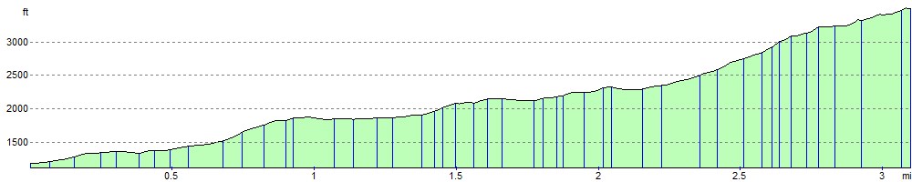
![]() Climb to the summit of Snowdon on this challenging walk in the Snowdonia National Park. Snowdon is the highest mountain in Wales, standing at a height of 1,085 metres (3,560 ft). The Pyg Track is one of six paths to the Snowdon summit. It is generally regarded as the most challenging as it crosses some rough and rocky terrain.
Climb to the summit of Snowdon on this challenging walk in the Snowdonia National Park. Snowdon is the highest mountain in Wales, standing at a height of 1,085 metres (3,560 ft). The Pyg Track is one of six paths to the Snowdon summit. It is generally regarded as the most challenging as it crosses some rough and rocky terrain.
The walk begins in the Pen y Pass car park and ascends to Bwlch y Moch. You continue past the beautiful glacial lakes of Llyn Llydaw and Glaslyn on your way to Bwlch Glas where you can see the tracks of the Snowdon Mountain Railway. The final section takes you from Bwlch Glas to the summit where there are magnificent views over Snowdonia, Ireland, the Isle of Man, the Peak District and the Lake District.
The Snowdon Miners Track also starts from the same car park and has the advantage of waterside sections along the mountain's three beautiful lakes of Llyn Teyrn, Llyn Llydaw and Glaslyn.
There's also the Snowdon Ranger Path,Snowdon Llanberis Path and the Snowdon Rhyd Ddu Path to try.
For an exhilarating circular ridge walk, taking in the Crib Goch ridge, try the Snowdon Horseshoe.
Postcode
LL55 4NY - Please note: Postcode may be approximate for some rural locationsSnowdon Pyg Track Ordnance Survey Map  - view and print off detailed OS map
Snowdon Pyg Track Open Street Map  - view and print off detailed map
Snowdon Pyg Track OS Map  - Mobile GPS OS Map with Location tracking
Snowdon Pyg Track Open Street Map  - Mobile GPS Map with Location tracking
Explore the Area with Google Street View 
Cycle Routes and Walking Routes Nearby
Photos

The Pyg Track with a view to Snowdon/Yr Wyddfa. A section of the Track with a clear view of the summit of Snowdon. High up on the right the line of the Track in the snow can be seen heading for the low point of Bwlch Glas.

A view towards Crib Goch from the Pyg track. On a clear day Crib Goch is in view much of the way from Pen-y-pass to Bwlch y Moch. Here the track crosses two streams as it changes direction and takes a more direct route towards the bwlch.

Two cairns on the Pyg Track. Looking east along the track with the faint line of the track snaking across the mountainside. The high point in the distance is Moel Siabod.

A walk up the track - at the top of the steps. At the top of the flight of stone steps the view opens out and the track can be seen winding its way across the hillside towards Bwlch y Moch.

The Llanberis Pass from track. On a clear day the views from the PYG track are magnificent. The A4086 runs along the bottom of the valley in close company with the Afon Nant Peris.

A rocky section. The track, such as it is here, picks its way through the jumble of boulders.

A view of the Glyderau from the track. Looking across the Llanberis Pass from the Pyg track towards the Glyderau. The small noticeable point on the skyline in the centre of the ridge is Castell y Gwynt with Glyder Fach to the right.

Between two streams. This photo was taken between the two small streams that flow down to the Afon Nant Peris in the valley below. The walkers are about to cross the second boulder bridge.
Elevation Profile