Snowdon Horseshoe Walk Route
![]()
![]() This classic circular walk to the Snowdon summit is a favourite for many. The 7 mile challenge is considered one of the finest ridge walks in the country. It is a very challenging circuit with knife edge sections along Crib Goch, where great care should be taken, particularly on windy days.
This classic circular walk to the Snowdon summit is a favourite for many. The 7 mile challenge is considered one of the finest ridge walks in the country. It is a very challenging circuit with knife edge sections along Crib Goch, where great care should be taken, particularly on windy days.
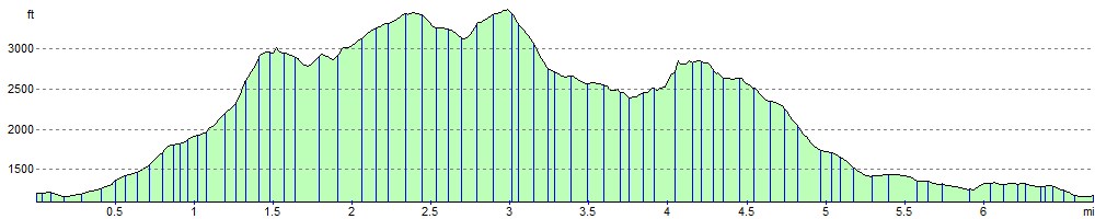
The walk starts from the Pen-y-pass car park at the top of the Llanberis Pass off the A4086 road. From here you pick up the Snowdon Pyg Track and head west towards Bwlch Y Moch. You continue west to the exhilarating section along Crib Goch. The high point stands at 923 metres (3,028 ft) above sea level. It involves a fair degree of scrambling and a challenging knife edge ridge so take your time! After tackling three rock-pinnacles you will arrive at the grassy col at Bwlch Coch. From here there are great views to Llyn Glas, Y Lliwedd's twin peaks and the Snowdon peak.
The next section climbs to Garnedd Ugain mountain, the second highest peak in Wales, lying just under one kilometre north of the summit of Snowdon itself. The route continues to the Finger Stone on Bwlch Glas, marking the top of the Pyg Track and Miners Track. Soon after you reach the summit of Snowdon where you can enjoy views as far as the Isle of Man, the Peak District, the Lake District and Ireland. A brass plaque shows all the surrounding mountains of Snowdonia you can see.
The route then steeply descends to Bwlch Cileau and Y Lliwedd using part of the Watkin Path. You continue the descent to Lliwedd Bach and then on to Llyn Llydaw. There are nice views here back to Crib Goch where you can see walkers tackling the same challenging ridge you have already completed!
Then next section passes along the shores of the pretty lake before following part of the Snowdon Miners Track to the much smaller Llyn Teyrn. From here it is a short stroll back to the car park and the end of the route.
There are lots of other routes up to the mountain summit to try. These include the Snowdon Llanberis Path, Miners Track, Pyg Track, Ranger Path and the Rhyd Ddu Path.
Snowdon Horseshoe Ordnance Survey Map  - view and print off detailed OS map
Snowdon Horseshoe Open Street Map  - view and print off detailed map
Snowdon Horseshoe OS Map  - Mobile GPS OS Map with Location tracking
Snowdon Horseshoe Open Street Map  - Mobile GPS Map with Location tracking
Further Information and Other Local Ideas
For more walking ideas in the area see the Snowdonia Walks page.
Cycle Routes and Walking Routes Nearby
Photos

The Snowdon Horseshoe is a classic scrambling route in the Snowdonia National park, North Wales

Crib Goch from near Garnedd Ugain. The western face of Crib Goch seen from further around the Snowdon Horseshoe.

On the Horseshoe

Llyn Teyrn and the Horseshoe. The Miners' Track curves round the north and eastern side of the lake. The pipeline in the distance carries water from Llyn Llydaw to the Cwm Dyli HEP station. The low lying area around the lake is very boggy.

Descent from Y Lliwedd to Llyn Llydaw. This sector contains the south-eastern end of the Snowdon Horseshoe ridge as it descends towards Llyn Llydaw.

The summit of Moel Gîd affords a fine view of the Horseshoe
Elevation Profile