Whernside Walk
![]()
![]() Climb to the highest point in North Yorkshire on this challenging circular walk in the Yorkshire Dales. Whernside is one of the Yorkshire Three Peaks, with the others being Ingleborough and Pen y ghent. The route runs for a distance of just under 8 miles with a steep ascent and descent, meaning a good level of fitness is required.
Climb to the highest point in North Yorkshire on this challenging circular walk in the Yorkshire Dales. Whernside is one of the Yorkshire Three Peaks, with the others being Ingleborough and Pen y ghent. The route runs for a distance of just under 8 miles with a steep ascent and descent, meaning a good level of fitness is required.
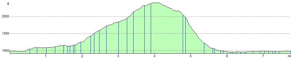
The circular walk begins at Ribblehead and heads to the Blue Clay Ridge via the magnificent Ribblehead Viaduct. You continue your ascent passing the pretty Little Dale Beck and Force Gill where you can see a series of waterfalls. The route then passes Knoutberry Hull and a small tarn before arriving at the 736 m (2,415 ft) Whernside summit. From here there are fantastic views over the Yorkshire Dales, the Lake District and Morecambe Bay.
From the summit you descend to Broadrake before crossing the lovely Winterscales Beck. You then follow the beck to Gunnerfleet Farm, and on to the finish point at Ribblehead.
To extend your walking in the area you could try our easy circular walk around the magnificent Ribblehead Viaduct. The Grade II* listed structure is one of the England's greatest monuments to Victorian engineering.
The long distance Dales Way and Ribble Way both pass near to the mountain so you could pick up these splendid trails to further explore the area.
Whernside Ordnance Survey Map  - view and print off detailed OS map
Whernside Open Street Map  - view and print off detailed map
Whernside OS Map  - Mobile GPS OS Map with Location tracking
Whernside Open Street Map  - Mobile GPS Map with Location tracking
Pubs/Cafes
After your exercise treat yourself to well earned refreshments at the Station Inn (Postcode: LA6 3AS). The pub is located next to the Ribblehead Viaduct and is very walker friendly. There's a good menu and you can also book rooms for the night. Just up the road to the west you'll find the Old Hill Inn (LA6 3AR). This pub dates all the way back to 1615 and is another popular spot for walkers exploring the Dales.
Further Information and Other Local Ideas
To extend your walk try the epic Yorkshire Three Peaks which also visits Pen y ghent and Ingleborough. There's also the Whernside Ingleborough Circular Walk which visits two of the peaks and also starts from Ribblehead.
For more walking ideas in the area see the Yorkshire Dales Walks and the Nidderdale Walks pages.
Cycle Routes and Walking Routes Nearby
Photos

Whernside Tarns. Looking North West to the Howgills from the larger of the tarns.

Ascending Whernside. Preferred route for 3 Peak Walkers, who do not wish to cause erosion by scaling the hill directly. The path heads towards Knoutberry Hill, before veering off to the left to gain the summit ridge.

The path just to the south of the summit of the hill, with an interested local in the foreground and Ingleborough in the background.

The trig point on Whernside

Cairn atop Little Whernside
.jpg)
Ribblehead Station. A stop on the Carlisle-Settle line high up in the moors. The station buildings now accommodate a tea room and visitor centre. It's a great spot from which to start a walk.

A view towards Ingleborough from the summit shelter on Whernside

Sheep near the summit
Elevation Profile