Bangor to Holyhead
![]()
![]() Follow National Cycle routes 5 and 8 through the Isle of Anglesey.
Follow National Cycle routes 5 and 8 through the Isle of Anglesey.
You start in Bangor by crossing the Menai Bridge into Anglesey with splendid views of the Menai Strait. The route then heads through the beautiful Anglesey countryside with views of the stunning Mynydd Bodafon - the highest point on Anglesey. You finish with a lovely run through Penrhos Coastal Park before finishing in Holyhead by the harbour.
Bangor to Holyhead Ordnance Survey Map  - view and print off detailed OS map
Bangor to Holyhead Open Street Map  - view and print off detailed map
Bangor to Holyhead OS Map  - Mobile GPS OS Map with Location tracking
Bangor to Holyhead Open Street Map  - Mobile GPS Map with Location tracking
Pubs/Cafes
Head to the Coffee Cups Cafe in Penrhos for some refreshments on your cycle. There's a good menu and little wooden huts in the garden where you can enjoy your lunch outside but with shelter. It's a friendly place and can be found at the south eastern end of the park with a postcode of LL65 2JE for your sat navs.
Further Information and Other Local Ideas
The popular Lon Las Ogwen cycle route starts just to the east of Bangor at Porth Penrhyn. The off road trail will take you south through Snowdonia to the beautiful Llyn Ogwen, passing the fascinating Penrhyn Quarry at Bethesda and the stunning glacial valley of Nant Ffrancon on the way on the way. It runs mostly along old railway paths and the River Ogwen before finishing at the lake and waterfall. The route is also suitable for walkers.
Cycle Routes and Walking Routes Nearby
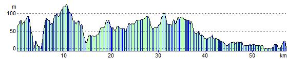
Elevation Profile