Barmouth to Machynlleth
![]()
![]() Travel from Barmouth to Machynlleth along National Cycle 8 route through Snowdonia.
Travel from Barmouth to Machynlleth along National Cycle 8 route through Snowdonia.
You start in Barmouth on the sea front and then cross the Barmouth Bridge over the Afon Mawddach river. The route then joins the traffic free Mawddach Trail taking you along the Mawddach estuary to Dolgellau. You then head south through Snowdonia passing through the villages of Aberllefenni and Corris and enjoying some wonderful scenery as you go. The first part of this section takes place on off road trails before you join an on road section that runs along the River Dulas and into Machynlleth.
Barmouth to Machynlleth Ordnance Survey Map  - view and print off detailed OS map
Barmouth to Machynlleth Open Street Map  - view and print off detailed map
Barmouth to Machynlleth OS Map  - Mobile GPS OS Map with Location tracking
Barmouth to Machynlleth Open Street Map  - Mobile GPS Map with Location tracking
Pubs/Cafes
The Red Lion in Machynlleth is a nice place to go for some refreshments after your exercise. The cosy pub has a good menu and is also dog friendly. Outside you can relax in the beer garden on warmer days. Inside there's interesting heavy rock memorabilia on the walls and a cosy atmosphere. You can find the pub at 11 Heol Maengwyn with a postcode of SY20 8AA for your sat navs.
Further Information and Other Local Ideas
In Barmouth you can try the excellent Panorama Walk and enjoy fine views over the surrounding area. The route also visits the interesting hill fort of Dinas Oleu.
Cycle Routes and Walking Routes Nearby
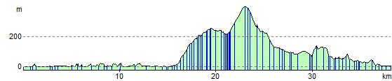
Elevation Profile