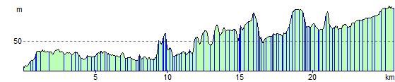
Bath to Midsomer Norton
16.8 miles (27 km)
![]()
![]() This ride follows National Cycle routes 4, 24 and 48 through some lovely Somerset scenery.
This ride follows National Cycle routes 4, 24 and 48 through some lovely Somerset scenery.
The route starts on Poultney Bridge near the centre of Bath and follows National Cycle Route 4 along the River Avon and the Kennet and Avon Canal before turning south west along National Cycle Route 24 near Monkton Combe.
You'll then follow a series of quiet roads and a dismantled railway line to Radstock passing Midford Castle as you go. A lovely off road stretch along the Wellow Brook in the beautiful Cotswolds takes you into Midsomer Norton.
Bath to Midsomer Norton Ordnance Survey Map  - view and print off detailed OS map
Bath to Midsomer Norton Open Street Map  - view and print off detailed map
Bath to Midsomer Norton OS Map  - Mobile GPS OS Map with Location tracking
Bath to Midsomer Norton Open Street Map  - Mobile GPS Map with Location tracking
Cycle Routes and Walking Routes Nearby
Elevation Profile