Bridgwater to Chard
![]()
![]() Starting in Bridgwater in Somerset on the Bridgwater and Taunton Canal follow National Cycle Route 33 to Langport and then Illminster before arriving in the destination town of Ilminster.
Starting in Bridgwater in Somerset on the Bridgwater and Taunton Canal follow National Cycle Route 33 to Langport and then Illminster before arriving in the destination town of Ilminster.
The backdrop to this route is the River Parret which you follow for most of the ride. You will also pass through the pretty villages of Burrowbridge and Muchelney.
Other highlights include the popular Chard to Ilminster Cycle Path. This traffic free section runs along a disused railway line for about 5 miles, passing the picturesque Chard Reservoir on the way.
Bridgwater to Chard Ordnance Survey Map  - view and print off detailed OS map
Bridgwater to Chard Open Street Map  - view and print off detailed map
Bridgwater to Chard OS Map  - Mobile GPS OS Map with Location tracking
Bridgwater to Chard Open Street Map  - Mobile GPS Map with Location tracking
Pubs/Cafes
There's lots of good options for refreshments in Chard town centre but we recommend heading to the Windwhistle Inn a little out of town. The main attraction here is a lovely 5 acre garden with panoramic views. On a clear day and you can see all the way to Glastonbury Tor and the Bristol Channel from here. It's a great place to relax and enjoy a meal on a summer day. Children and dogs are welcome in this expansive area too.
The inn also has an interesting history dating right back to the 17th Century when it was a notorious haunt of smugglers and highwaymen. More recently in 1902 Thomas Hardy mentioned the inn by name in his poem "A Trampwoman's Tragedy". It has a very good menu and a large car park too. You can find it on the A30 near Cricket St Thomas at a postcode of TA20 4DQ for your sat navs.
Further Information and Other Local Ideas
At the end of the route you could pay a visit to the lovely Chard Reservoir.
The Somerset Space Walk runs along the towpath of the canal. The route is lined with a number of interesting sculptures representing the planets of the Solar System. Look out for the scale model of the sun at Maunsel Lock and the description panels next to the sculptures to find out more.
Cycle Routes and Walking Routes Nearby
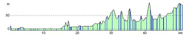
Elevation Profile