Campbeltown to Tarbert
![]()
![]() Travel along the Caledonia Way (National Cycle Route 78) and the Kintyre Peninsula on this spectacular ride which gives fabulous of views of Kilbrannan Sound and the west coast of the Isle of Arran.
Travel along the Caledonia Way (National Cycle Route 78) and the Kintyre Peninsula on this spectacular ride which gives fabulous of views of Kilbrannan Sound and the west coast of the Isle of Arran.
The ride starts by following quiet roads around Campbeltown Loch with terrific views of the striking Davaar Island. You continue along the coast towards Carradale passing the interesting 13th century Saddell Abbey on the way. More quiet coastal roads take you through Grogport to Claonaig where you head inland towards Tarbert. The ride finishes with a beautiful stretch along West Loch Tarbert taking you to the finish point at Tarbert Quay.
Campbeltown to Tarbert Ordnance Survey Map  - view and print off detailed OS map
Campbeltown to Tarbert Open Street Map  - view and print off detailed map
Campbeltown to Tarbert OS Map  - Mobile GPS OS Map with Location tracking
Campbeltown to Tarbert Open Street Map  - Mobile GPS Map with Location tracking
Further Information and Other Local Ideas
The epic Five Ferries Cycle Route passes through Tarbert. It uses 5 of the Calmac ferry crossings to visit Arran, the Kintyre Peninsula, the Cowal Peninsula and the Isle of Bute.
Cycle Routes and Walking Routes Nearby
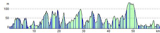
Elevation Profile