Devon Coast to Coast - Ilfracombe to Barnstaple to Plymouth Cycle Route
![]()
![]() This is the complete National Cycle Network route from Ilfracombe on the North coast of Devon to Plymouth on the south. The route follows National Cycle Route 27 and National Cycle Route 3 through this beautiful county, making use of miles of disused railway lines. Most of the ride is traffic free making for a really fabulous cycling experience.
This is the complete National Cycle Network route from Ilfracombe on the North coast of Devon to Plymouth on the south. The route follows National Cycle Route 27 and National Cycle Route 3 through this beautiful county, making use of miles of disused railway lines. Most of the ride is traffic free making for a really fabulous cycling experience.
The first section runs from Ilfracombe to Barnstaple and includes a coastal section around Woolacombe and a run along the Tarka Trail and the River Taw into Barnstaple.
You continue along the Tarka Trail from Barnstaple to Bideford with more waterside cycling along the River Taw and the River Torridge.
The next section runs from Bideford to Okehampton, along the Tarka trail and quiet country lanes. You'll pass Great Torrington and Hatherleigh while there are also waterside stretches along the River Torridge and then the River Okement into Okehampton.
The final section takes you from Okehampton to Plymouth through Dartmoor National Park following a series of quiet roads and traffic free paths along National Cycle Route 27. The first section takes you along the Granite Way to Lydford on a lovely off road path. You then continue on road to Tavistock with the impressive Brent Tor a highlight on this section.
After passing through Tavistock you cross the Grenofen Bridge over the River Walkham before a long traffic free woodland section takes you through Bickleigh Vale to Yelverton and Clearbrook. You then join the River Plym and the West Devon Way taking you to Plymouth.
Devon Coast to Coast Ordnance Survey Map  - view and print off detailed OS map
Devon Coast to Coast Open Street Map  - view and print off detailed map
Devon Coast to Coast OS Map  - Mobile GPS OS Map with Location tracking
Devon Coast to Coast Open Street Map  - Mobile GPS Map with Location tracking
Further Information and Other Local Ideas
Just to the south of Barnstaple the trail passes very close to Codden Hill at Bishop's Tawton. You could take a small detour from the route to climb to the summit where you'll find the monument to Caroline Thorpe, wife of local MP Jeremy Thorpe who became embroiled in the Thorpe scandal of the 1970s. There's also some splendid views over the area and waterside trails along the pretty Venn Stream to enjoy in this area.
In Okehampton The Fountain Inn is a good place for a pit stop. The inn has a lovely terrace and riverside garden area where you can relax on warmer days. They serve a fine Sunday carvery with a cosy interior and two real fires. You can find them on Fore Street with a postcode of EX20 1AP. The town itself is also well worth exploring with highlights including the 15th century Chapel of St James and the medieval ruins of Okehampton Castle which is now run as a tourist attraction by English Heritage.
Cycle Routes and Walking Routes Nearby
Photos

Plymouth , River Plym and Plymouth Sound
%2C_Harbour_--_2013_--_1785.jpg)
Ilfracombe (Devon, UK), Harbour -- 2013 -- 1785
.jpg)
View across the Gem Bridge (a replacement for the now-demolished Grenofen Viaduct, a railway bridge) which carries the National Cycle Network Route 27 across the Walkham Valley. The bridge is located near Plymouth, in Devon, England.

Downhill on route 27. After about 2 miles of uphill 1 in 36 gradient, a welcome downhill to Willingcott Cross past the former Mortehoe and Woolacombe station on route 27 of the National Cycle Network
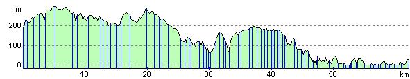
Elevation Profile