Leicester to Loughborough
15.5 miles (25 km)
![]()
![]() On this route you will follow National Cycle Route 6 from Leicester to Loughborough. The route starts by the tourist information centre in Leicester and soon joins the River Soar for some pleasant waterside riding with a stretch through the lovely Abbey Park an early highlight.
On this route you will follow National Cycle Route 6 from Leicester to Loughborough. The route starts by the tourist information centre in Leicester and soon joins the River Soar for some pleasant waterside riding with a stretch through the lovely Abbey Park an early highlight.
Just before Birstall you will pass through the lovely Watermead Country Park with over 12 lakes and ponds. From here you continue north towards Woodthorpe and then onto Loughborough never far from the River Soar. You finish by the tourist information centre in Loughborough.
Leicester to Loughborough Ordnance Survey Map  - view and print off detailed OS map
Leicester to Loughborough Open Street Map  - view and print off detailed map
Leicester to Loughborough OS Map  - Mobile GPS OS Map with Location tracking
Leicester to Loughborough Open Street Map  - Mobile GPS Map with Location tracking
Cycle Routes and Walking Routes Nearby
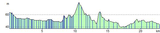
Elevation Profile