Nickey Line-Hemel-Hempstead to Harpenden
![]()
![]() This short off road cycle or walking route runs along the Nickey Line - a disused railway track running from Hemel Hempstead to Harpenden.
This short off road cycle or walking route runs along the Nickey Line - a disused railway track running from Hemel Hempstead to Harpenden.
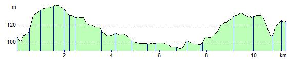
The trail forms part of National Cycle Route 57 (the Oxford to Welwyn Garden City route), and runs for about eight miles on a flat path.
This is a nice safe and easy route making it ideal for a family ride.
Please click here for more information
Nickey Line-Hemel-Hempstead to Harpenden Ordnance Survey Map  - view and print off detailed OS map
Nickey Line-Hemel-Hempstead to Harpenden Open Street Map  - view and print off detailed map
Nickey Line-Hemel-Hempstead to Harpenden OS Map  - Mobile GPS OS Map with Location tracking
Nickey Line-Hemel-Hempstead to Harpenden Open Street Map  - Mobile GPS Map with Location tracking
Pubs/Cafes
In the pretty village of Redbourn there's a couple of good options for a pit stop. The Hollybush dates from the 16th century and does a fine Sunday roast which you can enjoy in the nice garden area to the rear. You can find them at postcode AL3 7DU.
There's also the Cricketer's which is in a lovely spot overlooking Redbourn Common. They also serve high quality food and can be found at postcode AL3 7ND. Both pubs are also dog friendly if you have your canine friend with you.
Further Information and Other Local Ideas
In Harpenden you can pick up the epic Chilterns Cycleway. The signed circular trail runs for about 170 miles through the Chilterns AONB on quiet country lanes, visiting a series of delightful villages.
For more walking ideas in the area see the Hertfordshire Walks page.
Cycle Routes and Walking Routes Nearby
Photos

The trackbed of the dismantled Hemel Hempstead to Harpenden railway (The Nickey Line) viewed looking southwards towards Hemel from the M1 Motorway bridge.

The path viewed looking towards the Highfield area of Hemel Hempstead.

Hemel Hempstead: The Nickey Line. The trackbed of the dismantled Hemel Hempstead to Harpenden railway viewed looking across the bridge over Three Cherry Trees Lane. The route is now a footpath and is also one of the few opened sections of the proposed National Cycle Network Route 57 that will eventually run from Cricklade in Wiltshire to Welwyn Garden City in Hertfordshire.

The trail crosses the M1. The completed tunnel that takes the Nickey Line underneath the newly widened M1 at Redbourn.

Hemel Hempstead: B487 Queensway Viewed from the Nickey Line railway bridge, with St Pauls Road to the left and Cattsdell to the right.

Redbourn. The trackbed of the dismantled Hemel Hempstead to Harpenden railway line, viewed looking westwards over the bridge over the old A5 road, Redbourn High Street. The railway was built in 1877, but passenger trains ceased in 1947, and the track was finally lifted in 1979.

River Ver south of Redbourn. Viewed looking southwards and downstream from the trail bridge, the green cabinet is the housing for the Environment Agency's water gauging station. The bridge beyond carries the by-pass around the south side of Redbourn.
.jpg)
Former Duckhall railway embankment
Elevation Profile